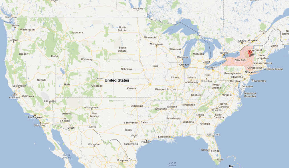
With interactive New York Map, view regional highways maps, road situations, transportation, lodging guide, geographical map, physical maps and more information. On New York Map, you can view all states, regions, cities, towns, districts, avenues, streets and popular centers' satellite, sketch and terrain maps.
MAP OF NEW YORK USA
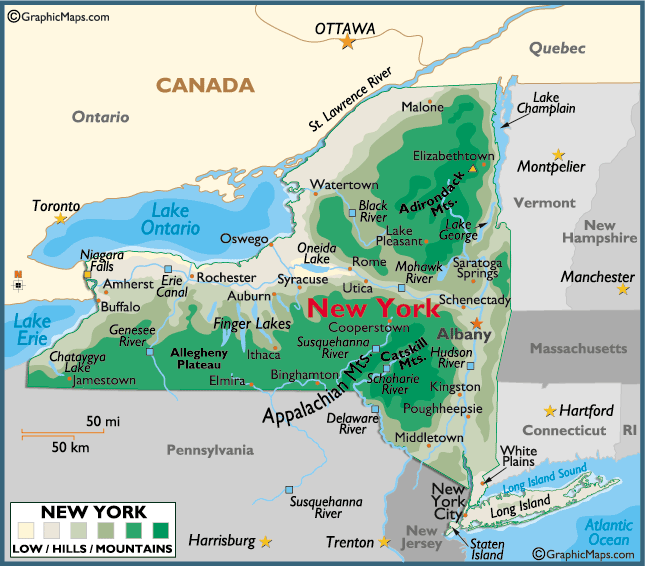
MAP OF NEWYORK
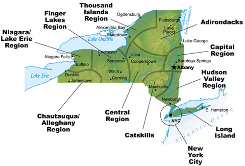
MAPS OF NEW YORK
All New York Cities Maps by Population
New York City Map -
(8,175,133)
Brooklyn Map -
(2,300,664)
Manhattan Map -
(1,487,536)
Buffalo Map -
(261,310)
Rochester Map -
(210,565)
Yonkers Map -
(195,976)
Syracuse Map -
(145,170)
Albany Map -
(97,856)
New Rochelle Map -
(77,062)
Cheektowaga Map -
(75,178)
Mount Vernon Map -
(67,292)
Schenectady Map -
(66,135)
Utica Map -
(62,235)
Brentwood Map -
(60,664)
Tonawanda Map -
(58,144)
White Plains Map -
(56,853)
Hempstead Map -
(53,891)
Levittown Map -
(51,881)
Irondequoit Map -
(51,692)
Niagara Falls Map -
(50,193)
Troy Map -
(50,129)
Binghamton Map -
(47,376)
West Seneca Map -
(44,711)
West Babylon Map -
(43,213)
Freeport Map -
(42,860)
Hicksville Map -
(41,547)
Coram Map -
(39,113)
East Meadow Map -
(38,132)
Valley Stream Map -
(37,511)
Brighton Map -
(36,609)
Commack Map -
(36,124)
Central Islip Map -
(34,450)
Rome Map -
(33,725)
New City Map -
(33,559)
Long Beach Map -
(33,275)
Elmont Map -
(33,198)
Huntington Station Map -
(33,029)
Poughkeepsie Map -
(32,736)
Oceanside Map -
(32,109)
Centereach Map -
(31,578)
North Tonawanda Map -
(31,568)
Spring Valley Map -
(31,347)
Jamestown Map -
(31,146)
Ithaca Map -
(30,014)
Franklin Square Map -
(29,320)
Elmira Map -
(29,200)
Port Chester Map -
(28,967)
Newburgh Map -
(28,866)
West Islip Map -
(28,335)
Middletown Map -
(28,086)
Shirley Map -
(27,854)
Deer Park Map -
(27,745)
Auburn Map -
(27,687)
Harrison Map -
(27,472)
Lindenhurst Map -
(27,253)
Holbrook Map -
(27,195)
Watertown Map -
(27,023)
Glen Cove Map -
(26,964)
Dix Hills Map -
(26,892)
Saratoga Springs Map -
(26,586)
Smithtown Map -
(26,470)
Bay Shore Map -
(26,337)
Plainview Map -
(26,217)
Ossining Map -
(25,060)
Uniondale Map -
(24,759)
Medford Map -
(24,142)
Baldwin Map -
(24,033)
Rockville Centre Map -
(24,023)
Kingston Map -
(23,893)
Peekskill Map -
(23,583)
Copiague Map -
(22,993)
East Patchogue Map -
(22,469)
Garden City Map -
(22,371)
Merrick Map -
(22,097)
Massapequa Map -
(21,685)
Lockport Map -
(21,165)
Hauppauge Map -
(20,882)
Rotterdam Map -
(20,652)
East Northport Map -
(20,217)
Kiryas Joel Map -
(20,175)
Lake Ronkonkoma Map -
(20,155)
Plattsburgh Map -
(19,989)
North Bellmore Map -
(19,941)
Selden Map -
(19,851)
Holtsville Map -
(19,714)
Eastchester Map -
(19,554)
Lynbrook Map -
(19,427)
Cortland Map -
(19,204)
Ronkonkoma Map -
(19,082)
East Massapequa Map -
(19,069)
Melville Map -
(18,985)
North Bay Shore Map -
(18,944)
Mamaroneck Map -
(18,929)
Wantagh Map -
(18,871)
West Hempstead Map -
(18,862)
Syosset Map -
(18,829)
Mineola Map -
(18,799)
Islip Map -
(18,689)
Amsterdam Map -
(18,620)
Monsey Map -
(18,412)
Oswego Map -
(18,142)
Lackawanna Map -
(18,141)
Huntington Map -
(18,046)
North Massapequa Map -
(17,886)
Nanuet Map -
(17,882)
North Amityville Map -
(17,862)
North Babylon Map -
(17,509)
Kings Park Map -
(17,282)
Scarsdale Map -
(17,166)
Woodmere Map -
(17,121)
Massapequa Park Map -
(17,008)
Sayville Map -
(16,853)
North Valley Stream Map -
(16,628)
Bethpage Map -
(16,429)
Roosevelt Map -
(16,258)
Bellmore Map -
(16,218)
Cohoes Map -
(16,168)
Pearl River Map -
(15,876)
Floral Park Map -
(15,863)
Port Washington Map -
(15,846)
Rye Map -
(15,720)
Gloversville Map -
(15,665)
Beacon Map -
(15,541)
Mastic Map -
(15,481)
Farmingville Map -
(15,481)
Setauket East Setauket Map -
(15,477)
Batavia Map -
(15,465)
Kenmore Map -
(15,423)
Depew Map -
(15,303)
Seaford Map -
(15,294)
Johnson City Map -
(15,174)
Westbury Map -
(15,146)
Tonawanda Map -
(15,130)
Eggertsville Map -
(15,019)
North New Hyde Park Map -
(14,899)
Glens Falls Map -
(14,700)
Greece Map -
(14,519)
South Farmingdale Map -
(14,486)
East Islip Map -
(14,475)
Olean Map -
(14,452)
Manorville Map -
(14,314)
Jefferson Valley Yorktown Map -
(14,142)
New Cassel Map -
(14,059)
Rocky Point Map -
(14,014)
Oneonta Map -
(13,901)
Greenlawn Map -
(13,742)
Stony Brook Map -
(13,740)
Hampton Bays Map -
(13,603)
Jericho Map -
(13,567)
Endicott Map -
(13,392)
Nesconset Map -
(13,387)
St. James Map -
(13,338)
Ridge Map -
(13,336)
Riverhead Map -
(13,299)
Geneva Map -
(13,261)
Fort Drum Map -
(12,955)
Mastic Beach Map -
(12,930)
Dunkirk Map -
(12,563)
Miller Place Map -
(12,339)
North Merrick Map -
(12,272)
Babylon Map -
(12,166)
Stony Point Map -
(12,147)
Mount Sinai Map -
(12,118)
Salisbury Map -
(12,093)
North Wantagh Map -
(11,960)
Haverstraw Map -
(11,910)
Fulton Map -
(11,896)
Terryville Map -
(11,849)
Patchogue Map -
(11,798)
North Lindenhurst Map -
(11,652)
Wyandanch Map -
(11,647)
North Bellport Map -
(11,545)
Endwell Map -
(11,446)
Oneida Map -
(11,393)
Tarrytown Map -
(11,277)
Fredonia Map -
(11,230)
Corning Map -
(11,183)
Elwood Map -
(11,177)
Lake Grove Map -
(11,163)
Ogdensburg Map -
(11,128)
Massena Map -
(10,936)
Mount Kisco Map -
(10,877)
Dobbs Ferry Map -
(10,875)
Suffern Map -
(10,723)
Woodbury Map -
(10,686)
Canandaigua Map -
(10,545)
Middle Island Map -
(10,483)
Lancaster Map -
(10,352)
Watervliet Map -
(10,254)
Fairmount Map -
(10,224)
Bohemia Map -
(10,180)
West Haverstraw Map -
(10,165)
Fort Salonga Map -
(10,008)
Great Neck Map -
(9,989)
Sleepy Hollow Map -
(9,870)
East Rockaway Map -
(9,818)
Inwood Map -
(9,792)
New Hyde Park Map -
(9,712)
Amityville Map -
(9,523)
North Gates Map -
(9,512)
Potsdam Map -
(9,428)
South Huntington Map -
(9,422)
Hamburg Map -
(9,409)
Rensselaer Map -
(9,392)
Rye Brook Map -
(9,347)
Stony Brook University Map -
(9,216)
Scotchtown Map -
(9,212)
Newark Map -
(9,145)
Valley Cottage Map -
(9,107)
New Windsor Map -
(8,922)
Woodbury Map -
(8,907)
Bayport Map -
(8,896)
Port Jervis Map -
(8,828)
Plainedge Map -
(8,817)
Johnstown Map -
(8,743)
Airmont Map -
(8,628)
Hornell Map -
(8,563)
Malverne Map -
(8,514)
Glens Falls North Map -
(8,443)
Mahopac Map -
(8,369)
Brockport Map -
(8,366)
Monroe Map -
(8,364)
Congers Map -
(8,363)
South Lockport Map -
(8,324)
Lake Carmel Map -
(8,282)
Farmingdale Map -
(8,189)
Baldwin Harbor Map -
(8,102)
Manhasset Map -
(8,080)
Croton on Hudson Map -
(8,070)
Ilion Map -
(8,053)
Geneseo Map -
(8,031)
Oakdale Map -
(7,974)
Chestnut Ridge Map -
(7,916)
Briarcliff Manor Map -
(7,867)
Hastings on Hudson Map -
(7,849)
Port Jefferson Station Map -
(7,838)
Garden City Park Map -
(7,806)
Colonie Map -
(7,793)
Port Jefferson Map -
(7,750)
Herkimer Map -
(7,743)
Scotia Map -
(7,729)
Wading River Map -
(7,719)
Sound Beach Map -
(7,612)
Center Moriches Map -
(7,580)
Hillcrest Map -
(7,558)
Northport Map -
(7,401)
Baldwinsville Map -
(7,378)
Baywood Map -
(7,350)
Williston Park Map -
(7,287)
Westmere Map -
(7,284)
Hudson Falls Map -
(7,281)
North Patchogue Map -
(7,246)
Southport Map -
(7,238)
Norwich Map -
(7,190)
Greenville Map -
(7,116)
West Glens Falls Map -
(7,071)
Pleasantville Map -
(7,019)
Orange Lake Map -
(6,982)
Walden Map -
(6,978)
East Hills Map -
(6,955)
New Square Map -
(6,944)
Pelham Map -
(6,910)
Mount Ivy Map -
(6,878)
Viola Map -
(6,868)
Mechanicstown Map -
(6,858)
Hewlett Map -
(6,819)
New Paltz Map -
(6,818)
Carmel Hamlet Map -
(6,817)
North Syracuse Map -
(6,800)
Myers Corner Map -
(6,790)
Nyack Map -
(6,765)
West Point Map -
(6,763)
Warwick Map -
(6,731)
Monticello Map -
(6,726)
Hudson Map -
(6,713)
Oyster Bay Map -
(6,707)
Great Neck Plaza Map -
(6,707)
Seneca Falls Map -
(6,681)
South Hill Map -
(6,673)
Bayville Map -
(6,669)
East Shoreham Map -
(6,666)
East Glenville Map -
(6,616)
Tappan Map -
(6,613)
Cedarhurst Map -
(6,592)
Springs Map -
(6,592)
East Rochester Map -
(6,587)
Solvay Map -
(6,584)
Roslyn Heights Map -
(6,577)
Manorhaven Map -
(6,556)
Calverton Map -
(6,510)
Tuckahoe Map -
(6,486)
East Farmingdale Map -
(6,484)
Lawrence Map -
(6,483)
Horseheads Map -
(6,461)
Mattydale Map -
(6,446)
Irvington Map -
(6,420)
Bronxville Map -
(6,323)
Canton Map -
(6,314)
East Aurora Map -
(6,236)
East Garden City Map -
(6,208)
Binghamton University Map -
(6,177)
University at Buffalo Map -
(6,066)
Medina Map -
(6,065)
Albion Map -
(6,056)
Lake Mohegan Map -
(6,010)
South Valley Stream Map -
(5,962)
Yaphank Map -
(5,945)
Malone Map -
(5,911)
Washingtonville Map -
(5,899)
Hilton Map -
(5,886)
Larchmont Map -
(5,864)
Salamanca Map -
(5,815)
Bath Map -
(5,786)
Southold Map -
(5,748)
Blauvelt Map -
(5,689)
Highland Map -
(5,647)
Wesley Hills Map -
(5,628)
Lakeview Map -
(5,615)
West Hills Map -
(5,592)
Old Bethpage Map -
(5,523)
Wappingers Falls Map -
(5,522)
Hamlin Map -
(5,521)
Fairview Map -
(5,515)
Harris Hill Map -
(5,508)
Centerport Map -
(5,508)
Pelham Manor Map -
(5,486)
Goshen Map -
(5,454)
Ballston Spa Map -
(5,409)
Saranac Lake Map -
(5,406)
Webster Map -
(5,399)
Islip Terrace Map -
(5,389)
Fairport Map -
(5,353)
Williamsville Map -
(5,300)
Hartsdale Map -
(5,293)
Big Flats Map -
(5,277)
East Moriches Map -
(5,249)
Mechanicville Map -
(5,196)
Albertson Map -
(5,182)
Waterloo Map -
(5,171)
Penn Yan Map -
(5,159)
New Hempstead Map -
(5,132)
Wheatley Heights Map -
(5,130)
Chittenango Map -
(5,081)
North Hills Map -
(5,075)
Cold Spring Harbor Map -
(5,070)
Thiells Map -
(5,032)
West Sayville Map -
(5,011)
Kings Point Map -
(5,005)
Sea Cliff Map -
(4,995)
Carle Place Map -
(4,981)
West Elmira Map -
(4,967)
Westvale Map -
(4,963)
Firthcliffe Map -
(4,949)
Little Falls Map -
(4,946)
Searingtown Map -
(4,915)
Gates Map -
(4,910)
Niskayuna Map -
(4,859)
Canastota Map -
(4,804)
Blue Point Map -
(4,773)
East Quogue Map -
(4,757)
Kaser Map -
(4,724)
Dansville Map -
(4,719)
Manlius Map -
(4,704)
Glen Head Map -
(4,697)
Wellsville Map -
(4,679)
Cobleskill Map -
(4,678)
Old Westbury Map -
(4,671)
Flower Hill Map -
(4,665)
Elmsford Map -
(4,664)
Island Park Map -
(4,655)
West Bay Shore Map -
(4,648)
Grandyle Village Map -
(4,629)
Galeville Map -
(4,617)
Hawthorne Map -
(4,586)
Orangeburg Map -
(4,568)
Montebello Map -
(4,526)
East Greenbush Map -
(4,487)
Flanders Map -
(4,472)
North Sea Map -
(4,458)
Ardsley Map -
(4,452)
Waverly Map -
(4,444)
Liberty Map -
(4,392)
Le Roy Map -
(4,391)
Gardnertown Map -
(4,373)
Fayetteville Map -
(4,373)
Clarkson Map -
(4,358)
Armonk Map -
(4,330)
Springville Map -
(4,296)
Herricks Map -
(4,295)
Lyncourt Map -
(4,250)
Hamilton Map -
(4,239)
University Gardens Map -
(4,226)
Mattituck Map -
(4,219)
Gang Mills Map -
(4,185)
Alfred Map -
(4,174)
East Hampton North Map -
(4,142)
Ellenville Map -
(4,135)
Spackenkill Map -
(4,123)
Bardonia Map -
(4,108)
Elmira Heights Map -
(4,097)
Catskill Map -
(4,081)
Arlington Map -
(4,061)
Gordon Heights Map -
(4,042)
Brewerton Map -
(4,029)
Garden City South Map -
(4,024)
North Great River Map -
(4,001)
Menands Map -
(3,990)
Heritage Hills Map -
(3,975)
Saugerties Map -
(3,971)
Chester Map -
(3,969)
Gouverneur Map -
(3,949)
Dannemora Map -
(3,936)
Highland Falls Map -
(3,900)
Sidney Map -
(3,900)
Owego Map -
(3,896)
Village Green Map -
(3,891)
Lake Erie Beach Map -
(3,872)
Putnam Lake Map -
(3,844)
Newfane Map -
(3,822)
Montgomery Map -
(3,814)
Glenwood Landing Map -
(3,779)
Whitesboro Map -
(3,772)
Thornwood Map -
(3,759)
Carthage Map -
(3,747)
Cayuga Heights Map -
(3,729)
SUNY Oswego Map -
(3,676)
Perry Map -
(3,673)
Marlboro Map -
(3,669)
Tupper Lake Map -
(3,667)
Sloan Map -
(3,661)
Lloyd Harbor Map -
(3,660)
Haviland Map -
(3,634)
Lyons Map -
(3,619)
Red Oaks Mill Map -
(3,613)
Spencerport Map -
(3,601)
Manhasset Hills Map -
(3,592)
Noyack Map -
(3,568)
Port Ewen Map -
(3,546)
Palmyra Map -
(3,536)
Lansing Map -
(3,529)
South Glens Falls Map -
(3,518)
Eden Map -
(3,516)
South Nyack Map -
(3,510)
Hoosick Falls Map -
(3,501)
Muttontown Map -
(3,497)
Calcium Map -
(3,491)
Warsaw Map -
(3,473)
Lowville Map -
(3,470)
Brookville Map -
(3,465)
Hurley Map -
(3,458)
Brookhaven Map -
(3,451)
Minoa Map -
(3,449)
West Nyack Map -
(3,439)
Locust Valley Map -
(3,406)
Avon Map -
(3,394)
Ticonderoga Map -
(3,382)
Fort Edward Map -
(3,375)
Vails Gate Map -
(3,369)
Cutchogue Map -
(3,349)
Islandia Map -
(3,335)
New York Mills Map -
(3,327)
Montauk Map -
(3,326)
Northwest Harbor Map -
(3,317)
Homer Map -
(3,291)
Wynantskill Map -
(3,276)
Ravena Map -
(3,268)
Orchard Park Map -
(3,246)
South Hempstead Map -
(3,243)
South Blooming Grove Map -
(3,234)
Westfield Map -
(3,224)
Wanakah Map -
(3,199)
Balmville Map -
(3,178)
Valhalla Map -
(3,162)
Port Washington North Map -
(3,154)
Greenwood Lake Map -
(3,154)
Southampton Map -
(3,109)
Pomona Map -
(3,103)
Warrensburg Map -
(3,103)
Brightwaters Map -
(3,103)
Fairview Map -
(3,099)
Walton Map -
(3,088)
Milton Map -
(3,087)
Delhi Map -
(3,087)
East Syracuse Map -
(3,084)
Westhampton Map -
(3,079)
Sherrill Map -
(3,071)
Sloatsburg Map -
(3,039)
Cornwall on Hudson Map -
(3,018)
Lakewood Map -
(3,002)
Bedford Hills Map -
(3,001)
Mount Morris Map -
(2,986)
Maybrook Map -
(2,958)
Lake Success Map -
(2,934)
Riverside Map -
(2,911)
Brinckerhoff Map -
(2,900)
Lido Beach Map -
(2,897)
Chenango Bridge Map -
(2,883)
South Fallsburg Map -
(2,870)
Akron Map -
(2,868)
Horseheads North Map -
(2,843)
Crown Heights Map -
(2,840)
Moriches Map -
(2,838)
Cazenovia Map -
(2,835)
Florida Map -
(2,833)
Coxsackie Map -
(2,813)
Voorheesville Map -
(2,789)
Lakeland Map -
(2,786)
Roslyn Map -
(2,770)
Great Neck Estates Map -
(2,761)
Mohawk Map -
(2,731)
Montrose Map -
(2,731)
Munsons Corners Map -
(2,728)
East Norwich Map -
(2,709)
Gowanda Map -
(2,709)
Lewiston Map -
(2,701)
Victor Map -
(2,696)
Munsey Park Map -
(2,693)
Yorkville Map -
(2,689)
Sands Point Map -
(2,675)
Honeoye Falls Map -
(2,674)
Walton Park Map -
(2,669)
West Sand Lake Map -
(2,660)
Rhinebeck Map -
(2,657)
Silver Creek Map -
(2,656)
Clarence Map -
(2,646)
Remsenburg Speonk Map -
(2,642)
Northeast Ithaca Map -
(2,641)
Green Island Map -
(2,620)
Thomaston Map -
(2,617)
Whitehall Map -
(2,614)
Alden Map -
(2,605)
Frankfort Map -
(2,598)
Conesus Lake Map -
(2,584)
Elma Center Map -
(2,571)
Corinth Map -
(2,559)
East Williston Map -
(2,556)
Blasdell Map -
(2,553)
Attica Map -
(2,547)
Granville Map -
(2,543)
Lake Placid Map -
(2,521)
North Boston Map -
(2,521)
Piermont Map -
(2,510)
Halesite Map -
(2,498)
Williamson Map -
(2,495)
Skaneateles Map -
(2,450)
Aquebogue Map -
(2,438)
Harriman Map -
(2,424)
Falconer Map -
(2,420)
Hampton Manor Map -
(2,417)
Barnum Island Map -
(2,414)
Jamestown West Map -
(2,408)
Lake Katrine Map -
(2,397)
Brewster Map -
(2,390)
Phoenix Map -
(2,382)
Watchtower Map -
(2,381)
Town Line Map -
(2,367)
Lincoln Park Map -
(2,366)
Pulaski Map -
(2,365)
Groton Map -
(2,363)
Pawling Map -
(2,347)
Liverpool Map -
(2,347)
Fort Plain Map -
(2,322)
Melrose Park Map -
(2,294)
Crompond Map -
(2,292)
Wallkill Map -
(2,288)
Canisteo Map -
(2,270)
Clarence Center Map -
(2,257)
Nedrow Map -
(2,244)
Beaver Dam Lake Map -
(2,242)
East Ithaca Map -
(2,231)
Camden Map -
(2,231)
Buchanan Map -
(2,230)
Canajoharie Map -
(2,229)
Country Knolls Map -
(2,224)
Saugerties South Map -
(2,218)
Bay Park Map -
(2,212)
Rouses Point Map -
(2,209)
Dolgeville Map -
(2,206)
Caledonia Map -
(2,201)
Morrisville Map -
(2,199)
Bellerose Terrace Map -
(2,198)
Greenport Map -
(2,197)
Oyster Bay Cove Map -
(2,197)
Shinnecock Hills Map -
(2,188)
Fishkill Map -
(2,171)
Sag Harbor Map -
(2,169)
Ontario Map -
(2,160)
Lima Map -
(2,139)
Old Brookville Map -
(2,134)
Clifton Springs Map -
(2,127)
Angola Map -
(2,127)
Greenport West Map -
(2,124)
Glasco Map -
(2,099)
Clyde Map -
(2,093)
Brewster Hill Map -
(2,089)
Woodstock Map -
(2,088)
Bellport Map -
(2,084)
Boonville Map -
(2,072)
Arcade Map -
(2,071)
Upper Nyack Map -
(2,063)
Lorenz Park Map -
(2,053)
East Atlantic Beach Map -
(2,049)
St. Bonaventure Map -
(2,044)
Cold Spring Map -
(2,013)
West Carthage Map -
(2,012)
Seneca Knolls Map -
(2,011)
Shrub Oak Map -
(2,011)
Scottsville Map -
(2,001)
Waterford Map -
(1,990)
Phelps Map -
(1,989)
Clayton Map -
(1,978)
Red Hook Map -
(1,961)
Churchville Map -
(1,961)
Laurel Hollow Map -
(1,952)
Clinton Map -
(1,942)
West End Map -
(1,940)
West Hurley Map -
(1,939)
Youngstown Map -
(1,935)
Hyde Park Map -
(1,908)
Frewsburg Map -
(1,906)
Clark Mills Map -
(1,905)
Shenorock Map -
(1,898)
Stewart Manor Map -
(1,896)
Atlantic Beach Map -
(1,891)
Dryden Map -
(1,890)
Cambridge Map -
(1,870)
Wayland Map -
(1,865)
Watkins Glen Map -
(1,859)
Cooperstown Map -
(1,852)
Central Square Map -
(1,848)
New Hartford Map -
(1,847)
Middleport Map -
(1,840)
Bedford Map -
(1,834)
Eastport Map -
(1,831)
Valatie Map -
(1,819)
Sodus Map -
(1,819)
Allegany Map -
(1,816)
Weedsport Map -
(1,815)
Keeseville Map -
(1,815)
Marcellus Map -
(1,813)
Oakfield Map -
(1,813)
Holley Map -
(1,811)
Painted Post Map -
(1,809)
Village of the Branch Map -
(1,807)
Trumansburg Map -
(1,797)
Yorktown Heights Map -
(1,781)
Pine Bush Map -
(1,780)
Greenwich Map -
(1,777)
Adams Map -
(1,775)
Chatham Map -
(1,770)
South Floral Park Map -
(1,764)
Addison Map -
(1,763)
Bridgehampton Map -
(1,756)
Nissequogue Map -
(1,749)
Rock Hill Map -
(1,742)
Franklinville Map -
(1,740)
Lattingtown Map -
(1,739)
Stillwater Map -
(1,738)
St. Johnsville Map -
(1,732)
Verplanck Map -
(1,729)
Dundee Map -
(1,725)
Westhampton Beach Map -
(1,721)
Altamont Map -
(1,720)
Montour Falls Map -
(1,711)
Mayville Map -
(1,711)
Jamesport Map -
(1,710)
Manchester Map -
(1,709)
Wolcott Map -
(1,701)
Upper Brookville Map -
(1,698)
Averill Park Map -
(1,693)
Houghton Map -
(1,693)
Washington Heights Map -
(1,689)
Billington Heights Map -
(1,685)
Kerhonkson Map -
(1,684)
Katonah Map -
(1,679)
Angola on the Lake Map -
(1,675)
Athens Map -
(1,668)
Deposit Map -
(1,663)
Niverville Map -
(1,662)
Norwood Map -
(1,657)
Sanborn Map -
(1,645)
Baiting Hollow Map -
(1,642)
Port Dickinson Map -
(1,641)
Rapids Map -
(1,636)
Golden's Bridge Map -
(1,630)
Peach Lake Map -
(1,629)
Cumberland Head Map -
(1,627)
Mexico Map -
(1,624)
Peru Map -
(1,591)
Mountain Lodge Park Map -
(1,588)
Tillson Map -
(1,586)
Waterville Map -
(1,583)
Greene Map -
(1,580)
Cuba Map -
(1,575)
Fort Montgomery Map -
(1,571)
Adams Center Map -
(1,568)
Sparkill Map -
(1,565)
Water Mill Map -
(1,559)
Morrisonville Map -
(1,545)
Crugers Map -
(1,534)
Macedon Map -
(1,523)
Lincolndale Map -
(1,521)
Marion Map -
(1,511)
Chadwicks Map -
(1,506)
Middleburgh Map -
(1,500)
Bridgeport Map -
(1,490)
Great River Map -
(1,489)
Brocton Map -
(1,486)
Castleton on Hudson Map -
(1,473)
Weston Mills Map -
(1,472)
Head of the Harbor Map -
(1,472)
Millbrook Map -
(1,452)
Clintondale Map -
(1,452)
Sackets Harbor Map -
(1,450)
Oxford Map -
(1,450)
Shortsville Map -
(1,439)
Chappaqua Map -
(1,436)
Huntington Bay Map -
(1,425)
Ransomville Map -
(1,419)
Northwest Ithaca Map -
(1,413)
Livonia Map -
(1,409)
Eatons Neck Map -
(1,406)
Milton Map -
(1,403)
Cairo Map -
(1,402)
Oriskany Map -
(1,400)
Laurel Map -
(1,394)
Schuylerville Map -
(1,386)
Philmont Map -
(1,379)
Nunda Map -
(1,377)
Stottville Map -
(1,375)
Tuckahoe Map -
(1,373)
Jordan Map -
(1,368)
Sherburne Map -
(1,367)
Plattsburgh West Map -
(1,364)
Bloomfield Map -
(1,361)
Cortland West Map -
(1,356)
Pittsford Map -
(1,355)
Bainbridge Map -
(1,355)
Pine Plains Map -
(1,353)
Rosendale Hamlet Map -
(1,349)
Plandome Map -
(1,349)
Black River Map -
(1,348)
Northville Map -
(1,340)
North Ballston Spa Map -
(1,338)
Shelter Island Map -
(1,333)
Norfolk Map -
(1,327)
Broadalbin Map -
(1,327)
Dover Plains Map -
(1,323)
Fort Covington Hamlet Map -
(1,308)
Harbor Isle Map -
(1,301)
Hagaman Map -
(1,292)
Port Byron Map -
(1,290)
Randolph Map -
(1,286)
Moravia Map -
(1,282)
Mineville Map -
(1,269)
Wilson Map -
(1,264)
Richfield Springs Map -
(1,264)
Hewlett Harbor Map -
(1,263)
Plattekill Map -
(1,260)
Merritt Park Map -
(1,256)
Philadelphia Map -
(1,252)
Roslyn Estates Map -
(1,251)
Gasport Map -
(1,248)
Wurtsboro Map -
(1,246)
Olcott Map -
(1,241)
North Collins Map -
(1,232)
Lake Luzerne Map -
(1,227)
Livingston Manor Map -
(1,221)
Point Lookout Map -
(1,219)
Friendship Map -
(1,218)
Camillus Map -
(1,213)
Kinderhook Map -
(1,211)
Holland Map -
(1,206)
Union Springs Map -
(1,197)
Port Henry Map -
(1,194)
Bellerose Map -
(1,193)
Great Neck Gardens Map -
(1,186)
Washington Mills Map -
(1,183)
Shokan Map -
(1,183)
Constantia Map -
(1,182)
Yorkshire Map -
(1,180)
Bergen Map -
(1,176)
Napanoch Map -
(1,174)
Stone Ridge Map -
(1,173)
Vernon Map -
(1,172)
Amagansett Map -
(1,165)
Kensington Map -
(1,161)
South Corning Map -
(1,145)
Pleasant Valley Map -
(1,145)
Little Valley Map -
(1,143)
Keuka Park Map -
(1,137)
Nassau Map -
(1,133)
Apalachin Map -
(1,131)
Unadilla Map -
(1,128)
Stamford Map -
(1,119)
Brownville Map -
(1,119)
Tivoli Map -
(1,118)
Worcester Map -
(1,113)
Celoron Map -
(1,112)
Champlain Map -
(1,101)
Northville Map -
(1,099)
Jefferson Heights Map -
(1,094)
Greenvale Map -
(1,094)
Delevan Map -
(1,089)
Hillside Lake Map -
(1,084)
East Hampton Map -
(1,083)
Alexandria Bay Map -
(1,078)
Minetto Map -
(1,069)
Otisville Map -
(1,068)
Poestenkill Map -
(1,061)
Elbridge Map -
(1,058)
McGraw Map -
(1,053)
Dexter Map -
(1,052)
Roslyn Harbor Map -
(1,051)
Shelter Island Heights Map -
(1,048)
Bolivar Map -
(1,047)
Andover Map -
(1,042)
Hannawa Falls Map -
(1,042)
Naples Map -
(1,041)
Palenville Map -
(1,037)
Zena Map -
(1,031)
Hancock Map -
(1,031)
New Berlin Map -
(1,028)
Castile Map -
(1,015)
Portville Map -
(1,014)
Otego Map -
(1,010)
Hadley Map -
(1,009)
Plandome Heights Map -
(1,005)
Tribes Hill Map -
(1,003)
Cattaraugus Map -
(1,002)
Baxter Estates Map -
(999)
Newark Valley Map -
(997)
Mill Neck Map -
(997)
Waddington Map -
(972)
Belmont Map -
(969)
Quogue Map -
(967)
Whitney Point Map -
(964)
Millerton Map -
(958)
Amenia Map -
(955)
Poquott Map -
(953)
Hillburn Map -
(951)
Gardiner Map -
(950)
Salem Map -
(946)
Avoca Map -
(946)
Russell Gardens Map -
(945)
Wilmington Map -
(937)
East Marion Map -
(926)
Schoharie Map -
(922)
Marathon Map -
(919)
Old Field Map -
(918)
Richmondville Map -
(918)
Windsor Map -
(916)
Claverack Red Mills Map -
(913)
Lake George Map -
(906)
Sodus Point Map -
(900)
Sylvan Beach Map -
(897)
Hillside Map -
(877)
Tully Map -
(873)
Ripley Map -
(872)
Plandome Manor Map -
(872)
Earlville Map -
(872)
Angelica Map -
(869)
Lime Lake Map -
(867)
Theresa Map -
(863)
Walker Valley Map -
(853)
Verona Map -
(852)
Candor Map -
(851)
Sand Ridge Map -
(849)
Woodridge Map -
(847)
Germantown Map -
(845)
Arkport Map -
(844)
Great Bend Map -
(843)
Lyndonville Map -
(838)
Cohocton Map -
(838)
Belfast Map -
(837)
North Haven Map -
(833)
Chateaugay Map -
(833)
Schroon Lake Map -
(833)
Mayfield Map -
(832)
Saddle Rock Map -
(830)
Savona Map -
(827)
West Winfield Map -
(826)
Copake Lake Map -
(823)
Afton Map -
(822)
Quiogue Map -
(816)
Pine Valley Map -
(813)
Titusville Map -
(811)
Matinecock Map -
(810)
Star Lake Map -
(809)
Copenhagen Map -
(801)
Stannards Map -
(798)
Fonda Map -
(795)
North Lynbrook Map -
(793)
Belle Terre Map -
(792)
Fultonville Map -
(784)
Silver Springs Map -
(782)
Woodsburgh Map -
(778)
North Hornell Map -
(778)
Sandy Creek Map -
(771)
Newfield Hamlet Map -
(759)
Spencer Map -
(759)
Madrid Map -
(757)
Lakeville Map -
(756)
Old Forge Map -
(756)
Elizabethtown Map -
(754)
Willsboro Map -
(753)
Cleveland Map -
(750)
Fair Haven Map -
(745)
Orient Map -
(743)
Palatine Bridge Map -
(737)
Oriskany Falls Map -
(732)
Altona Map -
(730)
Sherman Map -
(730)
Cape Vincent Map -
(726)
Aurora Map -
(724)
Mariaville Lake Map -
(722)
Heuvelton Map -
(714)
Campbell Map -
(713)
Scotts Corners Map -
(711)
Corfu Map -
(709)
Pultneyville Map -
(698)
Forestville Map -
(697)
Greenville Map -
(688)
Antwerp Map -
(686)
Peconic Map -
(683)
Rushville Map -
(677)
Chestertown Map -
(677)
Elba Map -
(676)
Port Leyden Map -
(672)
Paul Smiths Map -
(671)
Brasher Falls Map -
(669)
Hammondsport Map -
(661)
Sunset Bay Map -
(660)
Edmeston Map -
(657)
Prattsburgh Map -
(656)
Asharoken Map -
(654)
Wainscott Map -
(650)
Parishville Map -
(647)
Strykersville Map -
(647)
Pavilion Map -
(646)
Crystal Beach Map -
(644)
Newport Map -
(640)
North Rose Map -
(636)
Cassadaga Map -
(634)
Hartwick Map -
(629)
Nelsonville Map -
(628)
Harrisville Map -
(628)
High Falls Map -
(627)
Breesport Map -
(626)
Oneida Castle Map -
(625)
Chaumont Map -
(624)
Hailesboro Map -
(624)
Tuxedo Park Map -
(623)
Round Lake Map -
(623)
Evans Mills Map -
(621)
East Randolph Map -
(620)
South Dayton Map -
(620)
Croghan Map -
(618)
Downsville Map -
(617)
Gorham Map -
(617)
North Creek Map -
(616)
Unionville Map -
(612)
Scio Map -
(609)
La Fargeville Map -
(608)
East Avon Map -
(608)
Redwood Map -
(605)
Victory Map -
(605)
Fillmore Map -
(603)
Interlaken Map -
(602)
Ovid Map -
(602)
Coopers Plains Map -
(598)
Margaretville Map -
(596)
Nelliston Map -
(596)
Central Bridge Map -
(593)
Schaghticoke Map -
(592)
Odessa Map -
(591)
Sinclairville Map -
(588)
East Nassau Map -
(587)
Durhamville Map -
(584)
Morris Map -
(583)
Lacona Map -
(582)
Smallwood Map -
(580)
Wellsburg Map -
(580)
Honeoye Map -
(579)
Depauville Map -
(577)
Harbor Hills Map -
(575)
Forest Home Map -
(572)
Northampton Map -
(570)
Lyons Falls Map -
(566)
Chazy Map -
(565)
Ghent Map -
(564)
Accord Map -
(562)
Au Sable Forks Map -
(559)
Sharon Springs Map -
(558)
DeRuyter Map -
(558)
Savannah Map -
(558)
Hemlock Map -
(557)
Hannibal Map -
(555)
Schenevus Map -
(551)
Canaseraga Map -
(550)
Springwater Hamlet Map -
(549)
Cayuga Map -
(549)
Long Lake Map -
(547)
York Hamlet Map -
(544)
Wampsville Map -
(543)
Roscoe Map -
(541)
Tannersville Map -
(539)
Van Etten Map -
(537)
Salisbury Mills Map -
(536)
Barker Map -
(533)
Cato Map -
(532)
Red Creek Map -
(532)
Shoreham Map -
(531)
West Chazy Map -
(529)
Bliss Map -
(527)
Freeville Map -
(520)
Cherry Valley Map -
(520)
DeKalb Junction Map -
(519)
Westport Map -
(518)
West Valley Map -
(518)
Caroga Lake Map -
(518)
Bolton Landing Map -
(513)
Middleville Map -
(512)
Nichols Map -
(512)
Winthrop Map -
(510)
Alexander Map -
(509)
Poland Map -
(508)
Remsen Map -
(508)
Malverne Park Oaks Map -
(505)
Hunter Map -
(502)
Glen Park Map -
(502)
Riverside Map -
(497)
Fort Johnson Map -
(490)
Glen Aubrey Map -
(485)
Fort Ann Map -
(484)
Erin Map -
(483)
Panama Map -
(479)
Redford Map -
(477)
Munnsville Map -
(474)
Brushton Map -
(474)
Machias Map -
(471)
Bridgewater Map -
(470)
Leicester Map -
(468)
Valley Falls Map -
(466)
Almond Map -
(466)
Saddle Rock Estates Map -
(466)
Kennedy Map -
(465)
St. Regis Falls Map -
(464)
Cherry Creek Map -
(461)
Holland Patent Map -
(458)
Rifton Map -
(456)
Port Gibson Map -
(453)
Parish Map -
(450)
Richburg Map -
(450)
Cragsmoor Map -
(449)
Hewlett Neck Map -
(445)
Mooers Map -
(442)
Hobart Map -
(441)
Edwards Map -
(439)
Wyoming Map -
(434)
Narrowsburg Map -
(431)
Westmoreland Map -
(427)
Rhinecliff Map -
(425)
Pottersville Map -
(424)
Lyon Mountain Map -
(423)
Hermon Map -
(422)
Freedom Plains Map -
(421)
Livonia Center Map -
(421)
Bloomingburg Map -
(420)
Milford Map -
(415)
Centre Island Map -
(410)
Romulus Map -
(409)
Altmar Map -
(407)
Malden on Hudson Map -
(405)
Hewlett Bay Park Map -
(404)
Perrysburg Map -
(401)
Gilbertsville Map -
(399)
Morristown Map -
(395)
Duanesburg Map -
(391)
Busti Map -
(391)
Limestone Map -
(389)
Farnham Map -
(382)
Delanson Map -
(377)
Staatsburg Map -
(377)
Leeds Map -
(377)
Hopewell Junction Map -
(376)
Ellicottville Map -
(376)
Franklin Map -
(374)
Felts Mills Map -
(372)
Pike Map -
(371)
Windham Map -
(367)
Preston Potter Hollow Map -
(366)
Natural Bridge Map -
(365)
Bemus Point Map -
(364)
Rushford Map -
(363)
Dalton Map -
(362)
Guilford Map -
(362)
Jeffersonville Map -
(359)
Prattsville Map -
(355)
Mannsville Map -
(354)
Fabius Map -
(352)
Castorland Map -
(351)
Smithville Flats Map -
(351)
Fleischmanns Map -
(351)
Clayville Map -
(350)
Davenport Center Map -
(349)
New Suffolk Map -
(349)
Witherbee Map -
(347)
Esperance Map -
(345)
Colton Map -
(345)
Retsof Map -
(340)
Burdett Map -
(340)
Rensselaer Falls Map -
(332)
Cold Brook Map -
(329)
Speculator Map -
(324)
Richville Map -
(323)
Duane Lake Map -
(323)
Lisle Map -
(320)
Sagaponack Map -
(313)
Millport Map -
(312)
Phoenicia Map -
(309)
Meridian Map -
(309)
Dresden Map -
(308)
Conesus Hamlet Map -
(308)
Argyle Map -
(306)
Madison Map -
(305)
Blodgett Mills Map -
(303)
Cuylerville Map -
(297)
Deferiet Map -
(294)
Fire Island Map -
(292)
Lodi Map -
(291)
Prospect Map -
(291)
Oak Beach Captree Map -
(286)
Cove Neck Map -
(286)
Grand View on Hudson Map -
(285)
Barneveld Map -
(284)
Groveland Station Map -
(281)
Hammond Map -
(280)
East Kingston Map -
(276)
Pine Hill Map -
(275)
Pamelia Center Map -
(264)
Laurens Map -
(263)
Parc Map -
(254)
Andes Map -
(252)
Ellisburg Map -
(244)
Constableville Map -
(242)
South Lima Map -
(240)
Fishers Island Map -
(236)
Turin Map -
(232)
Gainesville Map -
(229)
Pierrepont Manor Map -
(228)
Fowlerville Map -
(227)
Three Mile Bay Map -
(227)
Belleville Map -
(226)
Henderson Map -
(224)
Piffard Map -
(220)
Hortonville Map -
(218)
Hall Map -
(216)
Bloomville Map -
(213)
Smyrna Map -
(213)
Burke Map -
(211)
Greigsville Map -
(209)
Napeague Map -
(200)
Cranberry Lake Map -
(200)
Galway Map -
(200)
Chautauqua Map -
(191)
Wadsworth Map -
(190)
Salt Point Map -
(190)
Cumminsville Map -
(183)
Lorraine Map -
(174)
Callicoon Map -
(167)
Plessis Map -
(164)
Rodman Map -
(153)
Ames Map -
(145)
Gilgo Map -
(131)
Scottsburg Map -
(117)
Kysorville Map -
(110)
Oxbow Map -
(108)
Herrings Map -
(90)
Fishers Landing Map -
(89)
Woodsville Map -
(80)
Ocean Beach Map -
(79)
Hunt Map -
(78)
Tuscarora Map -
(74)
Linwood Map -
(74)
Websters Crossing Map -
(69)
West Hampton Dunes Map -
(55)
Byersville Map -
(47)
Saltaire Map -
(37)
Thousand Island Park Map -
(31)
Dering Harbor Map -
(11)