With interactive Michigan Map, view regional highways maps, road situations, transportation, lodging guide, geographical map, physical maps and more information. On Michigan Map, you can view all states, regions, cities, towns, districts, avenues, streets and popular centers' satellite, sketch and terrain maps.
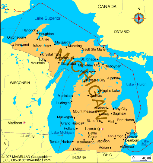
CITIES OF MICHIGAN MAP
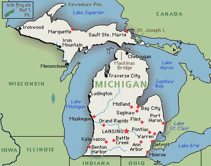
MICHIGAN MAP
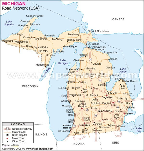
MICHIGAN ROAD MAP
All Michigan Cities Maps by Population
Detroit Map -
(713,777)
Grand Rapids Map -
(188,040)
Warren Map -
(134,056)
Sterling Heights Map -
(129,699)
Lansing Map -
(114,297)
Ann Arbor Map -
(113,934)
Flint Map -
(102,434)
Dearborn Map -
(98,153)
Livonia Map -
(96,942)
Clinton Township Map -
(96,796)
Canton Township Map -
(90,173)
Westland Map -
(84,094)
Troy Map -
(80,980)
Farmington Hills Map -
(79,740)
Kalamazoo Map -
(74,262)
Shelby Township Map -
(73,804)
Wyoming Map -
(72,125)
Southfield Map -
(71,739)
Waterford Township Map -
(71,707)
Rochester Hills Map -
(70,995)
West Bloomfield Township Map -
(64,690)
Taylor Map -
(63,131)
St. Clair Shores Map -
(59,715)
Pontiac Map -
(59,515)
Dearborn Heights Map -
(57,774)
Royal Oak Map -
(57,236)
Novi Map -
(55,224)
Battle Creek Map -
(52,347)
Saginaw Map -
(51,508)
Kentwood Map -
(48,707)
East Lansing Map -
(48,579)
Redford Township Map -
(48,362)
Roseville Map -
(47,299)
Portage Map -
(46,292)
Midland Map -
(41,863)
Bloomfield Township Map -
(41,070)
Muskegon Map -
(38,401)
Lincoln Park Map -
(38,144)
Bay City Map -
(34,932)
Jackson Map -
(33,534)
Holland Map -
(33,051)
Eastpointe Map -
(32,442)
Port Huron Map -
(30,184)
Southgate Map -
(30,047)
Burton Map -
(29,999)
Madison Heights Map -
(29,694)
Oak Park Map -
(29,319)
Allen Park Map -
(28,210)
Garden City Map -
(27,692)
Plymouth Township Map -
(27,524)
Mount Pleasant Map -
(26,016)
Wyandotte Map -
(25,883)
Forest Hills Map -
(25,867)
Inkster Map -
(25,369)
Harrison Township Map -
(24,587)
Norton Shores Map -
(23,994)
Romulus Map -
(23,989)
Holt Map -
(23,973)
Waverly Map -
(23,925)
Walker Map -
(23,537)
Hamtramck Map -
(22,423)
Auburn Hills Map -
(21,412)
Okemos Map -
(21,369)
Marquette Map -
(21,355)
Adrian Map -
(21,133)
Monroe Map -
(20,733)
Birmingham Map -
(20,103)
Ferndale Map -
(19,900)
Ypsilanti Map -
(19,435)
Haslett Map -
(19,220)
Trenton Map -
(18,853)
Wayne Map -
(17,593)
Allendale Map -
(17,579)
Jenison Map -
(16,538)
Hazel Park Map -
(16,422)
Mount Clemens Map -
(16,314)
Grosse Pointe Woods Map -
(16,135)
Grandville Map -
(15,378)
Owosso Map -
(15,194)
Berkley Map -
(14,970)
Traverse City Map -
(14,674)
Northview Map -
(14,541)
Fraser Map -
(14,480)
Cutlerville Map -
(14,370)
Harper Woods Map -
(14,236)
Sault Ste. Marie Map -
(14,144)
Wixom Map -
(13,498)
Woodhaven Map -
(12,875)
Rochester Map -
(12,711)
Escanaba Map -
(12,616)
Riverview Map -
(12,486)
New Baltimore Map -
(12,084)
Clawson Map -
(11,825)
Highland Park Map -
(11,776)
Fenton Map -
(11,756)
Niles Map -
(11,600)
Grosse Pointe Park Map -
(11,555)
Ionia Map -
(11,394)
South Lyon Map -
(11,327)
Sturgis Map -
(10,994)
Coldwater Map -
(10,945)
Muskegon Heights Map -
(10,856)
Melvindale Map -
(10,715)
East Grand Rapids Map -
(10,694)
Big Rapids Map -
(10,601)
Alpena Map -
(10,483)
Grand Haven Map -
(10,412)
Farmington Map -
(10,372)
Grosse Ile Township Map -
(10,371)
Cadillac Map -
(10,355)
Beverly Hills Map -
(10,267)
Beecher Map -
(10,232)
Comstock Park Map -
(10,088)
Benton Harbor Map -
(10,038)
Marysville Map -
(9,959)
Lambertville Map -
(9,953)
Flat Rock Map -
(9,878)
Ecorse Map -
(9,512)
Howell Map -
(9,489)
Grosse Pointe Farms Map -
(9,479)
Alma Map -
(9,383)
Plymouth Map -
(9,132)
Charlotte Map -
(9,074)
Lapeer Map -
(8,841)
Saline Map -
(8,810)
Westwood Map -
(8,653)
Albion Map -
(8,616)
Menominee Map -
(8,599)
Tecumseh Map -
(8,521)
Temperance Map -
(8,517)
Greenville Map -
(8,481)
Flushing Map -
(8,389)
St. Joseph Map -
(8,365)
Hillsdale Map -
(8,305)
Grand Blanc Map -
(8,276)
Center Line Map -
(8,257)
Mason Map -
(8,252)
Ludington Map -
(8,076)
River Rouge Map -
(7,903)
St. Johns Map -
(7,865)
Three Rivers Map -
(7,811)
Grand Ledge Map -
(7,786)
Houghton Map -
(7,708)
Fair Plain Map -
(7,631)
Iron Mountain Map -
(7,624)
St. Louis Map -
(7,482)
Brighton Map -
(7,444)
Hastings Map -
(7,350)
Hudsonville Map -
(7,116)
Marshall Map -
(7,088)
Walled Lake Map -
(6,999)
Freeland Map -
(6,969)
Bridgeport Map -
(6,950)
Buena Vista Map -
(6,816)
Shields Map -
(6,587)
Ishpeming Map -
(6,470)
South Monroe Map -
(6,433)
Whitmore Lake Map -
(6,423)
Eastwood Map -
(6,340)
Huntington Woods Map -
(6,238)
Manistee Map -
(6,226)
Milford Map -
(6,175)
Holly Map -
(6,086)
Northville Map -
(5,970)
Dowagiac Map -
(5,879)
Milan Map -
(5,836)
Byron Center Map -
(5,822)
Swartz Creek Map -
(5,758)
Belding Map -
(5,757)
Richmond Map -
(5,735)
Rockford Map -
(5,719)
Petoskey Map -
(5,670)
Lake Fenton Map -
(5,559)
Zeeland Map -
(5,504)
St. Clair Map -
(5,485)
Comstock Northwest Map -
(5,455)
Grosse Pointe Map -
(5,421)
Ironwood Map -
(5,387)
Springfield Map -
(5,260)
Eaton Rapids Map -
(5,214)
Davison Map -
(5,173)
Kingsford Map -
(5,133)
Allegan Map -
(4,998)
Gladstone Map -
(4,973)
Frankenmuth Map -
(4,944)
Chelsea Map -
(4,944)
Cheboygan Map -
(4,867)
Utica Map -
(4,757)
Vandercook Lake Map -
(4,721)
Michigan Center Map -
(4,672)
Gibraltar Map -
(4,656)
New Haven Map -
(4,642)
Hancock Map -
(4,634)
Negaunee Map -
(4,568)
DeWitt Map -
(4,507)
Buchanan Map -
(4,456)
South Haven Map -
(4,403)
Wolverine Lake Map -
(4,312)
Coopersville Map -
(4,275)
Marine City Map -
(4,248)
Caro Map -
(4,229)
Sparta Map -
(4,140)
Algonac Map -
(4,110)
Wolf Lake Map -
(4,104)
Benton Heights Map -
(4,084)
Fremont Map -
(4,081)
Wayland Map -
(4,079)
Lathrup Village Map -
(4,075)
Dexter Map -
(4,067)
Linden Map -
(3,991)
Belleville Map -
(3,991)
Dundee Map -
(3,957)
Otsego Map -
(3,956)
Portland Map -
(3,883)
Bloomfield Hills Map -
(3,869)
Williamston Map -
(3,854)
Roosevelt Park Map -
(3,831)
Plainwell Map -
(3,804)
North Muskegon Map -
(3,786)
Lowell Map -
(3,783)
Boyne City Map -
(3,735)
Gaylord Map -
(3,645)
Imlay City Map -
(3,597)
Romeo Map -
(3,596)
Paw Paw Map -
(3,534)
Paw Paw Lake Map -
(3,511)
Cedar Springs Map -
(3,509)
West Monroe Map -
(3,503)
Corunna Map -
(3,497)
Essexville Map -
(3,478)
Durand Map -
(3,446)
Oxford Map -
(3,436)
Houghton Lake Map -
(3,427)
Level Park Oak Park Map -
(3,409)
Skidway Lake Map -
(3,392)
Blissfield Map -
(3,340)
Middleville Map -
(3,319)
Rockwood Map -
(3,289)
Franklin Map -
(3,150)
Bad Axe Map -
(3,129)
Clare Map -
(3,118)
Manistique Map -
(3,097)
Mount Morris Map -
(3,086)
Iron River Map -
(3,029)
Beechwood Map -
(3,015)
Village of Grosse Pointe Shores Map -
(3,008)
Lake Orion Map -
(2,973)
Keego Harbor Map -
(2,970)
Gladwin Map -
(2,933)
Ithaca Map -
(2,910)
Vicksburg Map -
(2,906)
Ferrysburg Map -
(2,892)
Fowlerville Map -
(2,886)
Spring Arbor Map -
(2,881)
Norway Map -
(2,845)
Pearl Beach Map -
(2,829)
Rogers City Map -
(2,827)
East Tawas Map -
(2,808)
Canadian Lakes Map -
(2,756)
Whitehall Map -
(2,706)
Vassar Map -
(2,697)
Hartford Map -
(2,688)
Sandusky Map -
(2,679)
Almont Map -
(2,674)
St. Helen Map -
(2,668)
West Ishpeming Map -
(2,662)
Clio Map -
(2,646)
K. I. Sawyer Map -
(2,624)
Potterville Map -
(2,617)
Pleasant Ridge Map -
(2,526)
Argentine Map -
(2,525)
Charlevoix Map -
(2,513)
St. Ignace Map -
(2,452)
Croswell Map -
(2,447)
Cass City Map -
(2,428)
Pinckney Map -
(2,427)
Reed City Map -
(2,425)
Chesaning Map -
(2,394)
Orchard Lake Village Map -
(2,375)
Montague Map -
(2,361)
Edgemont Park Map -
(2,358)
Munising Map -
(2,355)
East Jordan Map -
(2,351)
Bronson Map -
(2,349)
Carleton Map -
(2,345)
Clinton Map -
(2,336)
Spring Lake Map -
(2,323)
Hudson Map -
(2,307)
Bridgman Map -
(2,291)
Jonesville Map -
(2,258)
Morenci Map -
(2,220)
Perry Map -
(2,188)
Trowbridge Park Map -
(2,176)
West Branch Map -
(2,139)
Hart Map -
(2,126)
Harrison Map -
(2,114)
Brownlee Park Map -
(2,108)
Manchester Map -
(2,091)
Detroit Beach Map -
(2,087)
Auburn Map -
(2,087)
Bath Map -
(2,083)
Constantine Map -
(2,076)
Shelby Map -
(2,065)
St. Charles Map -
(2,054)
Baraga Map -
(2,053)
Woodland Beach Map -
(2,049)
Kalkaska Map -
(2,020)
Manitou Beach Devils Lake Map -
(2,019)
Lake Odessa Map -
(2,018)
L'Anse Map -
(2,011)
Galesburg Map -
(2,009)
Mattawan Map -
(1,997)
Laurium Map -
(1,977)
Newaygo Map -
(1,976)
Indian River Map -
(1,959)
Yale Map -
(1,955)
Gwinn Map -
(1,917)
Bessemer Map -
(1,905)
Evart Map -
(1,903)
Lawton Map -
(1,900)
Capac Map -
(1,890)
Bangor Map -
(1,885)
Grayling Map -
(1,884)
New Buffalo Map -
(1,883)
Marlette Map -
(1,875)
Goodrich Map -
(1,860)
Wakefield Map -
(1,851)
Leslie Map -
(1,851)
Tawas City Map -
(1,827)
Mio Map -
(1,826)
Decatur Map -
(1,819)
Howard City Map -
(1,808)
Parchment Map -
(1,804)
Berrien Springs Map -
(1,800)
Cassopolis Map -
(1,774)
Sebewaing Map -
(1,759)
Watervliet Map -
(1,735)
Armada Map -
(1,730)
Stony Point Map -
(1,724)
Twin Lake Map -
(1,720)
Sylvan Lake Map -
(1,720)
Harbor Beach Map -
(1,703)
Prudenville Map -
(1,682)
Lake Isabella Map -
(1,681)
South Rockwood Map -
(1,675)
Homer Map -
(1,668)
Zilwaukee Map -
(1,658)
Montrose Map -
(1,657)
Quincy Map -
(1,652)
Elk Rapids Map -
(1,642)
Nashville Map -
(1,628)
Three Oaks Map -
(1,622)
Olivet Map -
(1,605)
Ovid Map -
(1,603)
Union City Map -
(1,599)
Birch Run Map -
(1,555)
Greilickville Map -
(1,530)
Schoolcraft Map -
(1,525)
White Pigeon Map -
(1,522)
Newberry Map -
(1,519)
Shepherd Map -
(1,515)
Caledonia Map -
(1,511)
Standish Map -
(1,509)
Ontonagon Map -
(1,494)
Coloma Map -
(1,483)
Kingsley Map -
(1,480)
Crystal Falls Map -
(1,469)
Hemlock Map -
(1,466)
Reese Map -
(1,454)
Ortonville Map -
(1,442)
Wacousta Map -
(1,440)
Luna Pier Map -
(1,436)
Centreville Map -
(1,425)
Stanton Map -
(1,417)
Sand Lake Map -
(1,412)
White Cloud Map -
(1,408)
Au Sable Map -
(1,404)
Fennville Map -
(1,398)
Harvey Map -
(1,393)
Lewiston Map -
(1,392)
Mancelona Map -
(1,390)
Litchfield Map -
(1,369)
Rapid City Map -
(1,352)
Shorewood Tower Hills Harbert Map -
(1,344)
Breckenridge Map -
(1,328)
Saranac Map -
(1,325)
Brown City Map -
(1,325)
Pinconning Map -
(1,307)
Lakewood Club Map -
(1,291)
Manton Map -
(1,287)
Frankfort Map -
(1,286)
Laingsburg Map -
(1,283)
Bellevue Map -
(1,282)
Webberville Map -
(1,272)
Edwardsburg Map -
(1,259)
Napoleon Map -
(1,258)
Coleman Map -
(1,243)
Dimondale Map -
(1,234)
Douglas Map -
(1,232)
Burt Map -
(1,228)
Ravenna Map -
(1,219)
Stockbridge Map -
(1,218)
Lake Beach Map -
(1,216)
Scottville Map -
(1,214)
Baldwin Map -
(1,208)
Fowler Map -
(1,208)
Pigeon Map -
(1,208)
Brooklyn Map -
(1,206)
Edmore Map -
(1,201)
Marcellus Map -
(1,198)
Harbor Springs Map -
(1,194)
Quinnesec Map -
(1,191)
Memphis Map -
(1,183)
South Gull Lake Map -
(1,182)
Lexington Map -
(1,178)
Grass Lake Map -
(1,173)
Colon Map -
(1,173)
Petersburg Map -
(1,146)
Stevensville Map -
(1,142)
Bingham Farms Map -
(1,111)
Carson City Map -
(1,093)
Fruitport Map -
(1,093)
Barnes Lake Millers Lake Map -
(1,093)
Bellaire Map -
(1,086)
Dollar Bay Map -
(1,082)
Reading Map -
(1,078)
Roscommon Map -
(1,075)
Millington Map -
(1,072)
Beaverton Map -
(1,071)
Kent City Map -
(1,057)
Concord Map -
(1,050)
North Branch Map -
(1,033)
Athens Map -
(1,024)
Lakeview Map -
(1,007)
Lake Linden Map -
(1,007)
Hubbard Lake Map -
(1,002)
Lawrence Map -
(996)
Attica Map -
(994)
Vineyard Lake Map -
(980)
Elsie Map -
(966)
Weidman Map -
(959)
Hesperia Map -
(954)
Central Lake Map -
(952)
Dryden Map -
(951)
Mayville Map -
(950)
Chums Corner Map -
(946)
Hubbell Map -
(946)
Ossineke Map -
(938)
Lake Victoria Map -
(930)
Morrice Map -
(927)
Lakes of the North Map -
(925)
Saugatuck Map -
(925)
Westphalia Map -
(923)
Onsted Map -
(917)
Caspian Map -
(906)
Oscoda Map -
(903)
Deerfield Map -
(898)
Middletown Map -
(897)
Grant Map -
(894)
Au Gres Map -
(889)
Augusta Map -
(885)
Village of Clarkston Map -
(882)
Onaway Map -
(880)
Baroda Map -
(873)
Marion Map -
(872)
Delton Map -
(872)
Farwell Map -
(871)
Mendon Map -
(870)
Otisville Map -
(864)
Shoreham Map -
(862)
Stephenson Map -
(862)
Sanford Map -
(859)
Ubly Map -
(858)
Pentwater Map -
(857)
Lake City Map -
(836)
Deckerville Map -
(830)
Gobles Map -
(829)
Burr Oak Map -
(828)
Atlanta Map -
(827)
Pellston Map -
(822)
Elkton Map -
(808)
Mackinaw City Map -
(806)
Springport Map -
(800)
Lyons Map -
(789)
Columbiaville Map -
(787)
Vernon Map -
(783)
Merrill Map -
(778)
Caseville Map -
(777)
Grawn Map -
(772)
Parma Map -
(769)
Climax Map -
(767)
Vermontville Map -
(759)
South Range Map -
(758)
Bay Shore Map -
(754)
Richland Map -
(751)
Alanson Map -
(738)
Calumet Map -
(726)
Robin Glen Indiantown Map -
(722)
Tekonsha Map -
(717)
Parkdale Map -
(704)
Hillman Map -
(701)
Buckley Map -
(697)
Fostoria Map -
(694)
Maple Rapids Map -
(672)
Port Austin Map -
(664)
McBain Map -
(656)
Rose City Map -
(653)
Sheridan Map -
(649)
Peck Map -
(632)
Eau Claire Map -
(625)
Port Sanilac Map -
(623)
Suttons Bay Map -
(618)
Hopkins Map -
(610)
Addison Map -
(605)
Muir Map -
(604)
Presque Isle Harbor Map -
(600)
Britton Map -
(586)
Interlochen Map -
(583)
New Lothrop Map -
(581)
Byron Map -
(581)
Sunfield Map -
(578)
Republic Map -
(570)
Oak Hill Map -
(569)
Metamora Map -
(565)
Dansville Map -
(563)
Fairgrove Map -
(563)
Ashley Map -
(563)
Maybee Map -
(562)
Vanderbilt Map -
(562)
Mulliken Map -
(553)
Galien Map -
(549)
Bancroft Map -
(545)
Waldron Map -
(538)
South Boardman Map -
(536)
Sterling Map -
(530)
Carsonville Map -
(527)
Northport Map -
(526)
Horton Bay Map -
(512)
Eastlake Map -
(512)
Camden Map -
(512)
Lennon Map -
(511)
Unionville Map -
(508)
Sand Lake Map -
(500)
New Troy Map -
(497)
Benzonia Map -
(497)
Harrisville Map -
(493)
Morley Map -
(493)
Mackinac Island Map -
(492)
Freeport Map -
(483)
Zeba Map -
(480)
North Adams Map -
(477)
Bay Port Map -
(477)
White Pine Map -
(474)
Kaleva Map -
(470)
Pewamo Map -
(469)
Mecosta Map -
(457)
Manistee Lake Map -
(456)
Bloomingdale Map -
(454)
New Era Map -
(451)
Kinde Map -
(448)
Snover Map -
(448)
Fife Lake Map -
(443)
Hanover Map -
(441)
Thompsonville Map -
(441)
Kingston Map -
(440)
Cement City Map -
(438)
Rothbury Map -
(432)
Hardwood Acres Map -
(432)
Watersmeet Map -
(428)
Woodland Map -
(425)
Powers Map -
(422)
Palmer Map -
(418)
Estral Beach Map -
(418)
Jasper Map -
(412)
Onekama Map -
(411)
Martin Map -
(410)
Brethren Map -
(410)
Perrinton Map -
(406)
Leonard Map -
(403)
Akron Map -
(402)
Henderson Map -
(399)
Hubbardston Map -
(395)
Clarksville Map -
(394)
Mesick Map -
(394)
Otter Lake Map -
(389)
Gagetown Map -
(388)
Whittemore Map -
(384)
Gaines Map -
(380)
Leland Map -
(377)
Empire Map -
(375)
Dowling Map -
(374)
Elberta Map -
(372)
Rosebush Map -
(368)
Oden Map -
(363)
Carp Lake Map -
(357)
Beal City Map -
(357)
Barryton Map -
(355)
Hersey Map -
(350)
Ellsworth Map -
(349)
Lupton Map -
(348)
Gaastra Map -
(347)
Clayton Map -
(344)
Beulah Map -
(342)
Montgomery Map -
(342)
Lincoln Map -
(337)
Advance Map -
(328)
Haring Map -
(328)
Honor Map -
(328)
Bear Lake Map -
(327)
De Tour Village Map -
(325)
Clifford Map -
(324)
Hickory Corners Map -
(322)
Casnovia Map -
(319)
Big Bay Map -
(319)
Luther Map -
(318)
Omer Map -
(313)
Lost Lake Woods Map -
(312)
Wellston Map -
(311)
Sherwood Map -
(309)
Canada Creek Ranch Map -
(304)
Vandalia Map -
(301)
Alba Map -
(295)
Boyne Falls Map -
(294)
Barton Hills Map -
(294)
Arcadia Map -
(291)
Lake Angelus Map -
(290)
Oakley Map -
(290)
Walloon Lake Map -
(290)
Bear Lake Map -
(286)
Custer Map -
(284)
Amasa Map -
(283)
Grand Beach Map -
(272)
Michigamme Map -
(271)
Emmett Map -
(269)
Lake Ann Map -
(268)
Port Hope Map -
(267)
Omena Map -
(267)
Prescott Map -
(266)
Jennings Map -
(264)
Burlington Map -
(261)
Daggett Map -
(258)
Le Roy Map -
(256)
Marenisco Map -
(254)
Lake Leelanau Map -
(253)
Applegate Map -
(248)
Walkerville Map -
(247)
Wolverine Map -
(244)
Owendale Map -
(241)
Wedgewood Map -
(237)
Posen Map -
(234)
Tustin Map -
(230)
Glen Arbor Map -
(229)
Garden Map -
(221)
Chatham Map -
(220)
Brutus Map -
(218)
Eastport Map -
(218)
Levering Map -
(215)
Loomis Map -
(213)
Stanwood Map -
(211)
Bendon Map -
(208)
Maple City Map -
(207)
Millersburg Map -
(206)
McBride Map -
(205)
St. James Map -
(205)
Conway Map -
(204)
Breedsville Map -
(199)
Minden City Map -
(197)
Copemish Map -
(194)
Fountain Map -
(193)
Carney Map -
(192)
Allen Map -
(191)
Copper City Map -
(190)
Michiana Map -
(182)
Twining Map -
(181)
Melvin Map -
(180)
Pierson Map -
(172)
Boon Map -
(167)
Stronach Map -
(162)
Ahmeek Map -
(146)
Alpha Map -
(145)
Free Soil Map -
(144)
Harrietta Map -
(143)
Norwood Map -
(142)
Ironton Map -
(140)
Forestville Map -
(136)
Bay View Map -
(133)
Maple Grove Map -
(132)
Alden Map -
(125)
Eagle Map -
(123)
Filer City Map -
(116)
Turner Map -
(114)
Copper Harbor Map -
(108)
Nessen City Map -
(97)
Cedar Map -
(93)
Cross Village Map -
(93)
Eagle Harbor Map -
(76)
Eagle River Map -
(71)
Ponshewaing Map -
(69)
Caberfae Map -
(64)
Crystal Mountain Map -
(54)
Crystal Downs Country Club Map -
(47)
Pilgrim Map -
(11)