With interactive Maryland Map, view regional highways maps, road situations, transportation, lodging guide, geographical map, physical maps and more information. On Maryland Map, you can view all states, regions, cities, towns, districts, avenues, streets and popular centers' satellite, sketch and terrain maps.
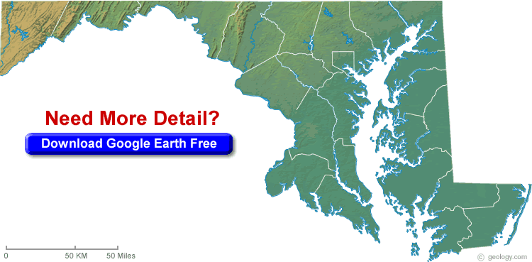
MARYLAND BLANK PHYSICAL MAP
MARYLAND CITY MAP

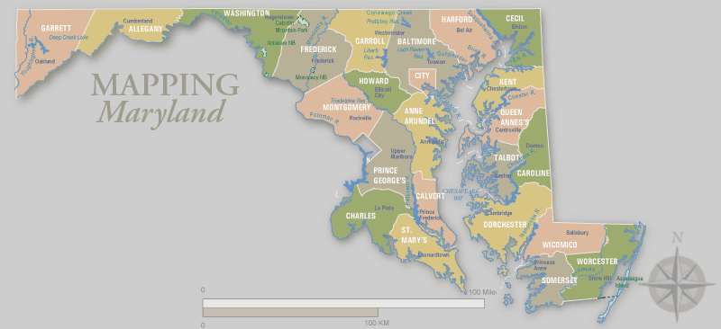
MARYLAND COUNTIES MAP
Navigating Baltimore's Best Kept Secrets
Please subscribe on "World Guide" channnel on Youtube at youtube.com/c/WorldGuide
The Earth, North America and Countries View from Space - Day Time and in the Night
All Maryland Cities Maps by Population
Baltimore Map -
(620,961)
Columbia Map -
(99,615)
Germantown Map -
(86,395)
Silver Spring Map -
(71,452)
Waldorf Map -
(67,752)
Glen Burnie Map -
(67,639)
Ellicott City Map -
(65,834)
Frederick Map -
(65,239)
Dundalk Map -
(63,597)
Rockville Map -
(61,209)
Bethesda Map -
(60,858)
Gaithersburg Map -
(59,933)
Towson Map -
(55,197)
Bowie Map -
(54,727)
Aspen Hill Map -
(48,759)
Wheaton Map -
(48,284)
Bel Air South Map -
(47,709)
Potomac Map -
(44,965)
Severn Map -
(44,231)
North Bethesda Map -
(43,828)
Catonsville Map -
(41,567)
Hagerstown Map -
(39,662)
Essex Map -
(39,262)
Annapolis Map -
(38,394)
Woodlawn Map -
(37,879)
Severna Park Map -
(37,634)
Odenton Map -
(37,132)
Clinton Map -
(35,970)
Olney Map -
(33,844)
Chillum Map -
(33,513)
Randallstown Map -
(32,430)
Montgomery Village Map -
(32,032)
Pikesville Map -
(30,764)
Parkville Map -
(30,734)
Owings Mills Map -
(30,622)
Bel Air North Map -
(30,568)
Eldersburg Map -
(30,531)
College Park Map -
(30,413)
Salisbury Map -
(30,343)
Carney Map -
(29,941)
Milford Mill Map -
(29,042)
Perry Hall Map -
(28,474)
Crofton Map -
(27,348)
South Laurel Map -
(26,112)
Reisterstown Map -
(25,968)
Suitland Map -
(25,825)
Edgewood Map -
(25,562)
Lochearn Map -
(25,333)
Middle River Map -
(25,191)
Laurel Map -
(25,115)
North Potomac Map -
(24,410)
Scaggsville Map -
(24,333)
Pasadena Map -
(24,287)
Fort Washington Map -
(23,717)
Fairland Map -
(23,681)
Ilchester Map -
(23,476)
Arnold Map -
(23,106)
Landover Map -
(23,078)
Greenbelt Map -
(23,068)
Cumberland Map -
(20,859)
Cockeysville Map -
(20,776)
Arbutus Map -
(20,483)
Lake Shore Map -
(19,477)
Rosedale Map -
(19,257)
Camp Springs Map -
(19,096)
Langley Park Map -
(18,755)
Westminster Map -
(18,590)
Ballenger Creek Map -
(18,274)
Calverton Map -
(17,724)
Oxon Hill Map -
(17,722)
Hyattsville Map -
(17,557)
White Oak Map -
(17,403)
Glassmanor Map -
(17,295)
Seabrook Map -
(17,287)
Redland Map -
(17,242)
Beltsville Map -
(16,772)
Ferndale Map -
(16,746)
Takoma Park Map -
(16,715)
Hillcrest Heights Map -
(16,469)
Maryland City Map -
(16,093)
Easton Map -
(15,945)
Parole Map -
(15,922)
Elkridge Map -
(15,593)
East Riverdale Map -
(15,509)
Elkton Map -
(15,443)
Damascus Map -
(15,257)
Rossville Map -
(15,147)
Cloverly Map -
(15,126)
Adelphi Map -
(15,086)
Aberdeen Map -
(14,959)
Colesville Map -
(14,647)
Brooklyn Park Map -
(14,373)
Clarksburg Map -
(13,766)
Glenmont Map -
(13,529)
Glenn Dale Map -
(13,466)
Havre de Grace Map -
(12,952)
Kettering Map -
(12,790)
Riviera Beach Map -
(12,677)
Joppatowne Map -
(12,616)
Kemp Mill Map -
(12,564)
Forestville Map -
(12,353)
Cambridge Map -
(12,326)
Overlea Map -
(12,275)
Travilah Map -
(12,159)
New Carrollton Map -
(12,135)
Bensville Map -
(11,923)
California Map -
(11,857)
Ocean Pines Map -
(11,710)
Lexington Park Map -
(11,626)
Mays Chapel Map -
(11,420)
Walker Mill Map -
(11,302)
Mitchellville Map -
(10,967)
Annapolis Neck Map -
(10,950)
Summerfield Map -
(10,898)
Largo Map -
(10,709)
Halfway Map -
(10,701)
Rosaryville Map -
(10,697)
Accokeek Map -
(10,573)
Chesapeake Ranch Estates Map -
(10,519)
Linthicum Map -
(10,324)
Lanham Map -
(10,157)
Bel Air Map -
(10,120)
Timonium Map -
(9,925)
Coral Hills Map -
(9,895)
Lake Arbor Map -
(9,776)
Brock Hall Map -
(9,552)
Chevy Chase Map -
(9,545)
North Kensington Map -
(9,514)
White Marsh Map -
(9,513)
Marlboro Village Map -
(9,438)
Fort Meade Map -
(9,327)
Mount Airy Map -
(9,288)
Friendly Map -
(9,250)
Urbana Map -
(9,175)
Bladensburg Map -
(9,148)
Marlton Map -
(9,031)
Edgewater Map -
(9,023)
Frostburg Map -
(9,002)
Fallston Map -
(8,958)
Garrison Map -
(8,823)
La Plata Map -
(8,753)
Leisure World Map -
(8,749)
Cape St. Claire Map -
(8,747)
Edgemere Map -
(8,669)
Linganore Map -
(8,543)
South Kensington Map -
(8,462)
Lansdowne Map -
(8,409)
Burtonsville Map -
(8,323)
Mayo Map -
(8,298)
Mount Rainier Map -
(8,080)
Four Corners Map -
(7,945)
Temple Hills Map -
(7,852)
Westphalia Map -
(7,266)
Bryans Road Map -
(7,244)
Jessup Map -
(7,137)
Ocean City Map -
(7,102)
Savage Map -
(7,054)
Baltimore Highlands Map -
(7,019)
Riverdale Park Map -
(6,956)
Robinwood Map -
(6,918)
Stevensville Map -
(6,803)
Darnestown Map -
(6,802)
Bowleys Quarters Map -
(6,755)
Taneytown Map -
(6,728)
Brandywine Map -
(6,719)
Forest Glen Map -
(6,582)
Lutherville Map -
(6,504)
Riverside Map -
(6,425)
Woodlawn Map -
(6,334)
Hampstead Map -
(6,323)
Cheverly Map -
(6,173)
Thurmont Map -
(6,170)
Hillandale Map -
(6,043)
Glenarden Map -
(6,000)
Silver Hill Map -
(5,950)
Brunswick Map -
(5,870)
District Heights Map -
(5,837)
Shady Side Map -
(5,803)
Walkersville Map -
(5,800)
Spring Ridge Map -
(5,795)
Chesapeake Beach Map -
(5,753)
Fountainhead Orchard Hills Map -
(5,666)
Ashton Sandy Spring Map -
(5,628)
Marlow Heights Map -
(5,618)
Chestertown Map -
(5,252)
Layhill Map -
(5,169)
Hampton Map -
(5,052)
Fairwood Map -
(5,031)
Deale Map -
(4,945)
Peppermill Village Map -
(4,895)
Poolesville Map -
(4,883)
Fruitland Map -
(4,866)
Manchester Map -
(4,808)
Naval Academy Map -
(4,802)
Friendship Heights Village Map -
(4,698)
Cresaptown Map -
(4,592)
Seat Pleasant Map -
(4,542)
Berlin Map -
(4,485)
North Laurel Map -
(4,474)
Sykesville Map -
(4,436)
Denton Map -
(4,418)
West Ocean City Map -
(4,375)
Perryville Map -
(4,361)
Capitol Heights Map -
(4,337)
Kingsville Map -
(4,318)
Centreville Map -
(4,285)
West Laurel Map -
(4,230)
Pocomoke City Map -
(4,184)
Chester Map -
(4,167)
Middletown Map -
(4,136)
Riva Map -
(4,076)
Woodmore Map -
(3,936)
Indian Head Map -
(3,844)
Golden Beach Map -
(3,796)
National Harbor Map -
(3,788)
Marlboro Meadows Map -
(3,672)
North East Map -
(3,572)
La Vale Map -
(3,551)
Brookmont Map -
(3,468)
Grasonville Map -
(3,425)
Pleasant Hills Map -
(3,379)
Boonsboro Map -
(3,336)
Huntingtown Map -
(3,311)
Princess Anne Map -
(3,290)
Berwyn Heights Map -
(3,123)
Maugansville Map -
(3,071)
Melwood Map -
(3,051)
Brentwood Map -
(3,046)
Delmar Map -
(3,003)
Springdale Map -
(2,994)
Smithsburg Map -
(2,975)
Andrews AFB Map -
(2,973)
St. James Map -
(2,953)
Leonardtown Map -
(2,930)
Jarrettsville Map -
(2,916)
Chevy Chase Map -
(2,824)
Emmitsburg Map -
(2,814)
Gambrills Map -
(2,800)
Rising Sun Map -
(2,781)
Federalsburg Map -
(2,739)
Drum Point Map -
(2,731)
Crisfield Map -
(2,726)
Croom Map -
(2,631)
Braddock Heights Map -
(2,608)
Herald Harbor Map -
(2,603)
Paramount Long Meadow Map -
(2,571)
University Park Map -
(2,548)
Prince Frederick Map -
(2,538)
Potomac Park Map -
(2,530)
Konterra Map -
(2,527)
Dunkirk Map -
(2,520)
Forest Heights Map -
(2,447)
Derwood Map -
(2,381)
Adamstown Map -
(2,372)
Solomons Map -
(2,368)
Perryman Map -
(2,342)
Wilson Conococheague Map -
(2,282)
Cabin John Map -
(2,280)
Kensington Map -
(2,213)
Hughesville Map -
(2,197)
Owings Map -
(2,149)
Williamsport Map -
(2,137)
Baden Map -
(2,128)
Jefferson Map -
(2,111)
Snow Hill Map -
(2,103)
Aberdeen Proving Ground Map -
(2,093)
Mountain Lake Park Map -
(2,092)
Hurlock Map -
(2,092)
Fulton Map -
(2,049)
Morningside Map -
(2,015)
North Beach Map -
(1,978)
Arden on the Severn Map -
(1,953)
Chevy Chase Village Map -
(1,953)
Greensboro Map -
(1,931)
Queenland Map -
(1,929)
Oakland Map -
(1,925)
Westernport Map -
(1,888)
Lusby Map -
(1,835)
Long Beach Map -
(1,821)
Crownsville Map -
(1,757)
Kingstown Map -
(1,733)
Landover Hills Map -
(1,687)
Ridgely Map -
(1,639)
Myersville Map -
(1,626)
Spencerville Map -
(1,594)
Hancock Map -
(1,545)
Mechanicsville Map -
(1,508)
Fairmount Heights Map -
(1,494)
Cavetown Map -
(1,473)
Point of Rocks Map -
(1,466)
Bartonsville Map -
(1,451)
Edmonston Map -
(1,445)
Charlotte Hall Map -
(1,420)
Pittsville Map -
(1,417)
Colmar Manor Map -
(1,404)
New Windsor Map -
(1,396)
Rock Hall Map -
(1,310)
Cottage City Map -
(1,305)
Queen Anne Map -
(1,280)
Bel Air Map -
(1,258)
Algonquin Map -
(1,241)
Somerset Map -
(1,216)
Lonaconing Map -
(1,214)
Charlestown Map -
(1,183)
Cobb Island Map -
(1,166)
Keedysville Map -
(1,152)
Woodsboro Map -
(1,141)
Potomac Heights Map -
(1,117)
Highfield Cascade Map -
(1,112)
Hebron Map -
(1,084)
Bowling Green Map -
(1,077)
Trappe Map -
(1,077)
Highland Map -
(1,034)
St. Michaels Map -
(1,029)
Buckeystown Map -
(1,019)
Garrett Park Map -
(992)
Aquasco Map -
(981)
Union Bridge Map -
(975)
Willards Map -
(958)
Libertytown Map -
(950)
Martin's Additions Map -
(933)
Eckhart Mines Map -
(932)
Chevy Chase View Map -
(920)
Funkstown Map -
(904)
Mount Savage Map -
(873)
Piney Point Map -
(864)
Eden Map -
(823)
Calvert Beach Map -
(808)
Tilghman Island Map -
(784)
Mount Vernon Map -
(779)
Grantsville Map -
(766)
Chevy Chase Section Three Map -
(760)
Church Hill Map -
(745)
St. Leonard Map -
(742)
Preston Map -
(719)
Cedarville Map -
(717)
Sharpsburg Map -
(705)
Pylesville Map -
(693)
Rawlings Map -
(693)
Galesville Map -
(684)
Chesapeake City Map -
(673)
Queenstown Map -
(664)
Cecilton Map -
(663)
Chevy Chase Section Five Map -
(658)
New Market Map -
(656)
Bryantown Map -
(655)
Port Deposit Map -
(653)
Oxford Map -
(651)
Sharptown Map -
(651)
Millington Map -
(642)
Upper Marlboro Map -
(631)
Bowmans Addition Map -
(627)
Galena Map -
(612)
Fairplay Map -
(580)
Leitersburg Map -
(573)
Ellerslie Map -
(572)
Kent Narrows Map -
(567)
Cordova Map -
(562)
Mount Aetna Map -
(561)
Washington Grove Map -
(555)
Loch Lynn Heights Map -
(552)
Finzel Map -
(547)
Secretary Map -
(535)
Bishopville Map -
(531)
North Chevy Chase Map -
(519)
North Brentwood Map -
(517)
Pomfret Map -
(517)
Mount Lena Map -
(515)
McCoole Map -
(511)
Butlertown Map -
(505)
Sudlersville Map -
(497)
Friendsville Map -
(491)
Fairlee Map -
(490)
Deal Island Map -
(471)
Tilghmanton Map -
(465)
Tall Timbers Map -
(462)
Fairmount Map -
(457)
Barton Map -
(457)
Corriganville Map -
(455)
West Pocomoke Map -
(454)
Pinesburg Map -
(449)
Friendship Map -
(447)
Midland Map -
(446)
Monrovia Map -
(416)
Darlington Map -
(409)
Broomes Island Map -
(405)
East New Market Map -
(400)
Deer Park Map -
(399)
San Mar Map -
(384)
Grahamtown Map -
(364)
Zihlman Map -
(362)
Clear Spring Map -
(358)
Downsville Map -
(355)
Sabillasville Map -
(354)
Pleasant Grove Map -
(353)
Chance Map -
(353)
Laytonsville Map -
(353)
Mardela Springs Map -
(347)
Betterton Map -
(345)
Parsonsburg Map -
(339)
Newark Map -
(336)
Bagtown Map -
(333)
Tolchester Map -
(329)
Accident Map -
(325)
Kitzmiller Map -
(321)
Midlothian Map -
(320)
Fort Ritchie Map -
(314)
Bloomington Map -
(305)
Rosemont Map -
(294)
Franklin Map -
(290)
Smith Island Map -
(276)
Vienna Map -
(271)
Danville Map -
(271)
Crellin Map -
(264)
Benedict Map -
(261)
St. George Island Map -
(257)
Glen Echo Map -
(255)
Breathedsville Map -
(254)
Beaver Creek Map -
(251)
Worton Map -
(249)
Goldsboro Map -
(246)
Moscow Map -
(240)
Chewsville Map -
(238)
Mapleville Map -
(238)
Tyaskin Map -
(236)
Shaft Map -
(235)
Garretts Mill Map -
(234)
Edgemont Map -
(231)
Greensburg Map -
(229)
Nanticoke Map -
(225)
Queen Anne Map -
(222)
Allen Map -
(210)
Madison Map -
(204)
Jugtown Map -
(204)
Bivalve Map -
(201)
Kennedyville Map -
(199)
Powellville Map -
(189)
Jesterville Map -
(188)
Sandy Hook Map -
(188)
Cearfoss Map -
(178)
Flintstone Map -
(177)
Rohrersville Map -
(175)
Taylors Island Map -
(173)
Bier Map -
(173)
Trego Rohrersville Station Map -
(172)
Barnesville Map -
(172)
Charlton Map -
(171)
Edesville Map -
(169)
Dames Quarter Map -
(167)
Pecktonville Map -
(167)
Ringgold Map -
(166)
Dargan Map -
(165)
Fishing Creek Map -
(163)
Hillsboro Map -
(161)
Mount Briar Map -
(160)
Pondsville Map -
(158)
Williston Map -
(155)
Carlos Map -
(153)
Burkittsville Map -
(151)
Whaleyville Map -
(149)
Girdletree Map -
(149)
Henderson Map -
(146)
Georgetown Map -
(143)
Marydel Map -
(141)
Vale Summit Map -
(139)
Galestown Map -
(138)
Templeville Map -
(138)
Brookeville Map -
(134)
Yarrowsburg Map -
(133)
Quantico Map -
(133)
Mercersville Map -
(130)
Choptank Map -
(129)
Gilmore Map -
(127)
Kemps Mill Map -
(126)
Church Creek Map -
(125)
Barclay Map -
(120)
Klondike Map -
(118)
Nikep Map -
(116)
Jennings Map -
(113)
Woodland Map -
(113)
Gapland Map -
(109)
Rock Point Map -
(107)
Gorman Map -
(106)
Nanticoke Acres Map -
(103)
Dawson Map -
(103)
Frenchtown Rumbly Map -
(100)
Highland Beach Map -
(96)
Stockton Map -
(92)
Antietam Map -
(89)
Brownsville Map -
(89)
Oldtown Map -
(86)
Hutton Map -
(86)
Big Spring Map -
(84)
Big Pool Map -
(82)
Fairview Map -
(76)
Clarysville Map -
(73)
Barrelville Map -
(73)
Detmold Map -
(71)
Middleburg Map -
(70)
Luke Map -
(65)
Indian Springs Map -
(64)
Eagle Harbor Map -
(63)
Brookview Map -
(60)
Eldorado Map -
(59)
Swanton Map -
(58)
National Map -
(56)
Ernstville Map -
(56)
Spring Gap Map -
(55)
Reid Map -
(54)
Elliott Map -
(52)
West Denton Map -
(52)
Whitehaven Map -
(43)
Little Orleans Map -
(42)
Waterview Map -
(40)
Ocean Map -
(32)
Bakersville Map -
(30)
Eakles Mill Map -
(27)
Port Tobacco Village Map -
(13)