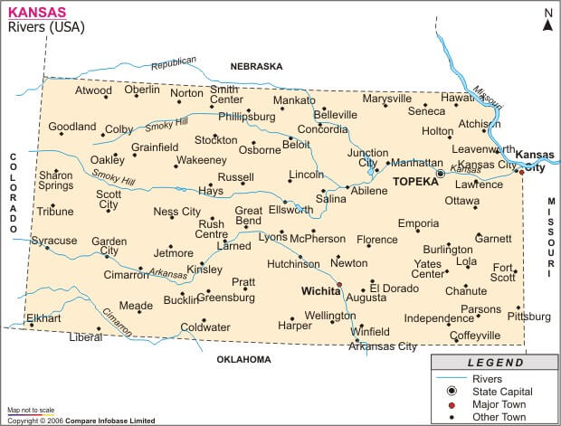
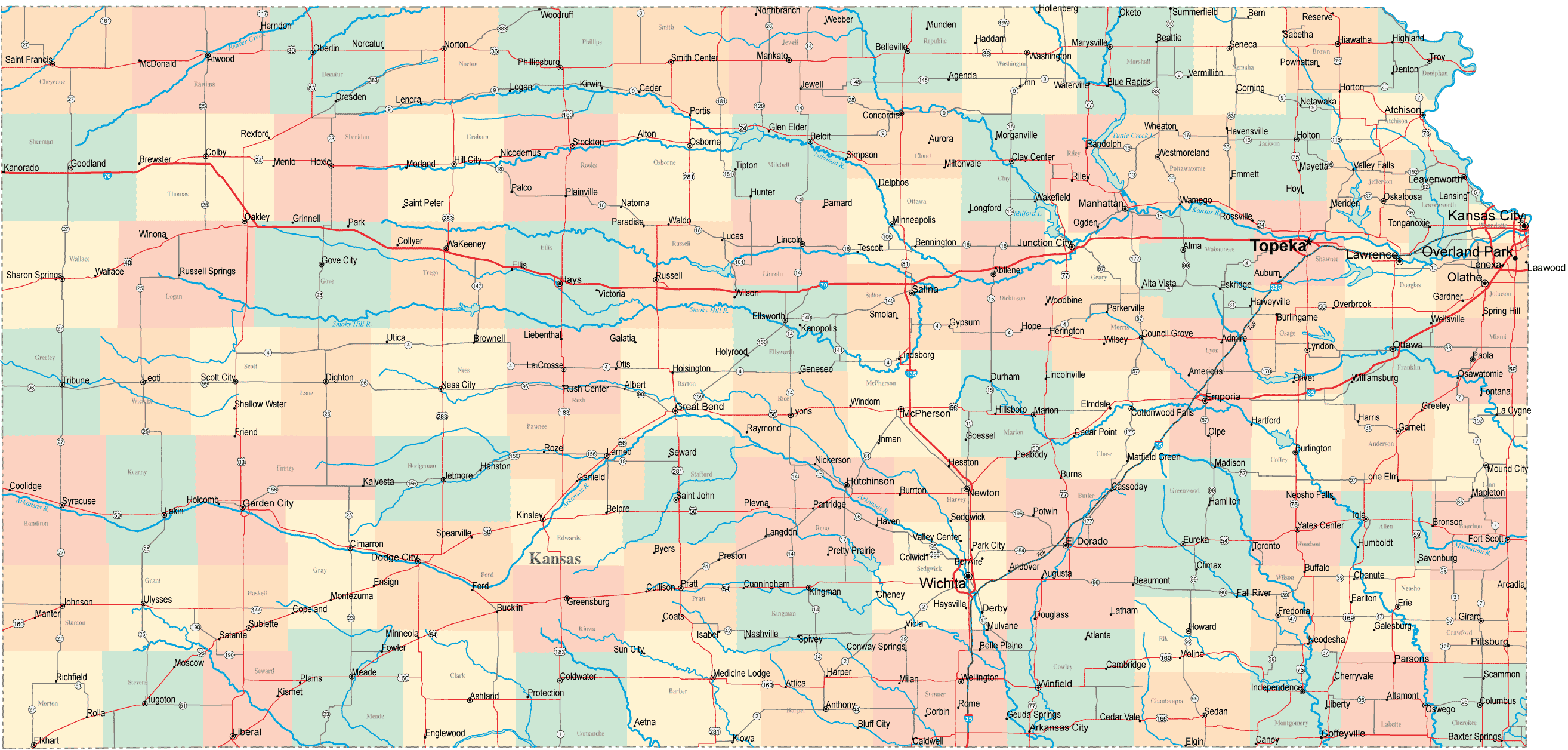
With interactive Kansas Map, view regional highways maps, road situations, transportation, lodging guide, geographical map, physical maps and more information. On Kansas Map, you can view all states, regions, cities, towns, districts, avenues, streets and popular centers' satellite, sketch and terrain maps.
KANSAS CITIES MAP
KANSAS CITIES TOWNS MAP
KANSAS POLITICAL MAP
All Kansas Cities Maps by Population
Wichita Map -
(382,368)
Overland Park Map -
(173,372)
Kansas City Map -
(145,786)
Topeka Map -
(127,473)
Olathe Map -
(125,872)
Lawrence Map -
(87,643)
Shawnee Map -
(62,209)
Manhattan Map -
(52,281)
Lenexa Map -
(48,190)
Salina Map -
(47,707)
Hutchinson Map -
(42,080)
Leavenworth Map -
(35,251)
Leawood Map -
(31,867)
Dodge City Map -
(27,340)
Garden City Map -
(26,658)
Emporia Map -
(24,916)
Junction City Map -
(23,353)
Derby Map -
(22,158)
Prairie Village Map -
(21,447)
Liberal Map -
(20,525)
Hays Map -
(20,510)
Pittsburg Map -
(20,233)
Newton Map -
(19,132)
Gardner Map -
(19,123)
Great Bend Map -
(15,995)
McPherson Map -
(13,155)
El Dorado Map -
(13,021)
Ottawa Map -
(12,649)
Arkansas City Map -
(12,415)
Winfield Map -
(12,301)
Andover Map -
(11,791)
Lansing Map -
(11,265)
Atchison Map -
(11,021)
Merriam Map -
(11,003)
Haysville Map -
(10,826)
Parsons Map -
(10,500)
Coffeyville Map -
(10,295)
Independence Map -
(9,483)
Mission Map -
(9,323)
Augusta Map -
(9,274)
Chanute Map -
(9,119)
Wellington Map -
(8,172)
Fort Scott Map -
(8,087)
Fort Riley Map -
(7,761)
Bonner Springs Map -
(7,314)
Park City Map -
(7,297)
Abilene Map -
(6,844)
Pratt Map -
(6,835)
Valley Center Map -
(6,822)
Bel Aire Map -
(6,769)
Roeland Park Map -
(6,731)
Ulysses Map -
(6,161)
Eudora Map -
(6,136)
Mulvane Map -
(6,111)
De Soto Map -
(5,720)
Iola Map -
(5,704)
Paola Map -
(5,602)
Spring Hill Map -
(5,437)
Concordia Map -
(5,395)
Colby Map -
(5,387)
Tonganoxie Map -
(4,996)
Basehor Map -
(4,613)
Baldwin City Map -
(4,515)
Russell Map -
(4,506)
Goodland Map -
(4,489)
Osawatomie Map -
(4,447)
Wamego Map -
(4,372)
Goddard Map -
(4,344)
Edwardsville Map -
(4,340)
Clay Center Map -
(4,334)
Louisburg Map -
(4,315)
Baxter Springs Map -
(4,238)
Larned Map -
(4,054)
Rose Hill Map -
(3,931)
Hugoton Map -
(3,904)
Fairway Map -
(3,882)
Beloit Map -
(3,835)
Scott City Map -
(3,816)
Lyons Map -
(3,739)
Hesston Map -
(3,709)
Mission Hills Map -
(3,498)
Lindsborg Map -
(3,458)
Frontenac Map -
(3,437)
Maize Map -
(3,420)
Garnett Map -
(3,415)
Holton Map -
(3,329)
Columbus Map -
(3,312)
Marysville Map -
(3,294)
Oaklawn Sunview Map -
(3,276)
Kingman Map -
(3,177)
Hiawatha Map -
(3,172)
Ellsworth Map -
(3,120)
Galena Map -
(3,085)
Hillsboro Map -
(2,993)
Osage City Map -
(2,943)
Norton Map -
(2,928)
Girard Map -
(2,789)
Hoisington Map -
(2,706)
Burlington Map -
(2,674)
Eureka Map -
(2,633)
St. Marys Map -
(2,627)
Phillipsburg Map -
(2,581)
Sabetha Map -
(2,571)
Herington Map -
(2,526)
Neodesha Map -
(2,486)
Fredonia Map -
(2,482)
Clearwater Map -
(2,481)
South Hutchinson Map -
(2,457)
Cherryvale Map -
(2,367)
Sterling Map -
(2,328)
Anthony Map -
(2,269)
Lakin Map -
(2,216)
Elkhart Map -
(2,205)
Caney Map -
(2,203)
Cimarron Map -
(2,184)
Council Grove Map -
(2,182)
Ellinwood Map -
(2,131)
Cheney Map -
(2,094)
Holcomb Map -
(2,094)
Ogden Map -
(2,087)
Halstead Map -
(2,085)
Ellis Map -
(2,062)
Oakley Map -
(2,045)
Minneapolis Map -
(2,032)
Medicine Lodge Map -
(2,009)
Belleville Map -
(1,991)
Seneca Map -
(1,991)
Humboldt Map -
(1,953)
Marion Map -
(1,927)
Kechi Map -
(1,909)
Plainville Map -
(1,903)
WaKeeney Map -
(1,862)
Wellsville Map -
(1,857)
Oswego Map -
(1,829)
Syracuse Map -
(1,812)
Oberlin Map -
(1,788)
McConnell AFB Map -
(1,777)
Horton Map -
(1,776)
North Newton Map -
(1,759)
Moundridge Map -
(1,737)
Meade Map -
(1,721)
Douglass Map -
(1,700)
Sedgwick Map -
(1,695)
Belle Plaine Map -
(1,681)
Edgerton Map -
(1,671)
Smith Center Map -
(1,665)
Grandview Plaza Map -
(1,560)
Leoti Map -
(1,534)
Westwood Map -
(1,506)
Johnson City Map -
(1,495)
Arma Map -
(1,481)
Hill City Map -
(1,474)
Harper Map -
(1,473)
Kinsley Map -
(1,457)
Sublette Map -
(1,453)
Towanda Map -
(1,450)
Ness City Map -
(1,449)
Silver Lake Map -
(1,439)
Carbondale Map -
(1,437)
Osborne Map -
(1,431)
Yates Center Map -
(1,417)
Chapman Map -
(1,393)
Inman Map -
(1,377)
Wathena Map -
(1,364)
La Crosse Map -
(1,342)
Stockton Map -
(1,329)
St. Francis Map -
(1,329)
Buhler Map -
(1,327)
Colwich Map -
(1,327)
Lincoln Center Map -
(1,297)
St. John Map -
(1,295)
Conway Springs Map -
(1,272)
Haven Map -
(1,237)
Auburn Map -
(1,227)
Elwood Map -
(1,224)
Pleasanton Map -
(1,216)
Victoria Map -
(1,214)
Peabody Map -
(1,210)
Hoxie Map -
(1,201)
Atwood Map -
(1,194)
Valley Falls Map -
(1,192)
Rossville Map -
(1,151)
Erie Map -
(1,150)
La Cygne Map -
(1,149)
Plains Map -
(1,146)
Satanta Map -
(1,133)
Washington Map -
(1,131)
Chetopa Map -
(1,125)
Sedan Map -
(1,124)
Oskaloosa Map -
(1,113)
Solomon Map -
(1,095)
Altamont Map -
(1,080)
Nickerson Map -
(1,070)
Caldwell Map -
(1,068)
Overbrook Map -
(1,058)
Lyndon Map -
(1,052)
Oxford Map -
(1,049)
Stafford Map -
(1,042)
Dighton Map -
(1,038)
Kiowa Map -
(1,026)
Blue Rapids Map -
(1,019)
Highland Map -
(1,012)
Troy Map -
(1,010)
Wakefield Map -
(980)
Montezuma Map -
(966)
Lebo Map -
(940)
Riley Map -
(939)
Burlingame Map -
(934)
Riverton Map -
(929)
Perry Map -
(929)
Andale Map -
(928)
Quinter Map -
(918)
Lake Quivira Map -
(906)
Cottonwood Falls Map -
(903)
Burrton Map -
(901)
Downs Map -
(900)
Americus Map -
(894)
McLouth Map -
(880)
Benton Map -
(880)
Galva Map -
(870)
Mankato Map -
(869)
Ashland Map -
(867)
Jetmore Map -
(867)
Enterprise Map -
(855)
Garden Plain Map -
(849)
Alma Map -
(832)
Pomona Map -
(832)
Coldwater Map -
(828)
Meriden Map -
(813)
Mount Hope Map -
(813)
Linn Valley Map -
(804)
Bucklin Map -
(794)
Wilson Map -
(781)
Westmoreland Map -
(778)
Greensburg Map -
(777)
Spearville Map -
(773)
Eastborough Map -
(773)
Sharon Springs Map -
(748)
Canton Map -
(748)
Udall Map -
(746)
Minneola Map -
(745)
Tribune Map -
(741)
Frankfort Map -
(726)
Whitewater Map -
(718)
Clyde Map -
(716)
Cherokee Map -
(714)
Scranton Map -
(710)
Leon Map -
(704)
Onaga Map -
(702)
Madison Map -
(701)
Haviland Map -
(701)
Deerfield Map -
(700)
Mound City Map -
(694)
Howard Map -
(687)
Weir Map -
(686)
Hanover Map -
(682)
Pretty Prairie Map -
(680)
Waterville Map -
(680)
Bennington Map -
(672)
Hoyt Map -
(669)
Claflin Map -
(645)
Ozawkie Map -
(645)
Marquette Map -
(641)
St. George Map -
(639)
Nortonville Map -
(637)
St. Paul Map -
(629)
Attica Map -
(626)
Lecompton Map -
(625)
Maple Hill Map -
(620)
White City Map -
(618)
Wilroads Gardens Map -
(609)
Waverly Map -
(592)
Fowler Map -
(590)
Logan Map -
(589)
Cedar Vale Map -
(579)
La Harpe Map -
(578)
Gas Map -
(564)
LeRoy Map -
(561)
Moran Map -
(558)
Little River Map -
(557)
Clifton Map -
(554)
Winchester Map -
(551)
Macksville Map -
(549)
Effingham Map -
(546)
Olpe Map -
(546)
Miltonvale Map -
(539)
Goessel Map -
(539)
Burden Map -
(535)
Eskridge Map -
(534)
Vassar Map -
(530)
Bentley Map -
(530)
Milford Map -
(530)
Mulberry Map -
(520)
Protection Map -
(514)
Centralia Map -
(512)
Argonia Map -
(501)
Glasco Map -
(498)
Thayer Map -
(497)
Kanopolis Map -
(492)
Norwich Map -
(491)
Strong City Map -
(485)
Scammon Map -
(482)
Chase Map -
(477)
Arlington Map -
(473)
Kensington Map -
(473)
Cawker City Map -
(469)
Florence Map -
(465)
Richmond Map -
(464)
Kismet Map -
(459)
Cunningham Map -
(454)
Lewis Map -
(451)
Leonardville Map -
(449)
Potwin Map -
(449)
Bird City Map -
(447)
Holyrood Map -
(447)
Glen Elder Map -
(445)
Alta Vista Map -
(444)
Edna Map -
(442)
Rolla Map -
(442)
Jewell Map -
(432)
Dearing Map -
(431)
Parkerfield Map -
(426)
Altoona Map -
(414)
Assaria Map -
(413)
Linn Map -
(410)
Chicopee Map -
(408)
Almena Map -
(408)
Colony Map -
(408)
Mound Valley Map -
(407)
Axtell Map -
(406)
Gypsum Map -
(405)
McCune Map -
(405)
Williamsburg Map -
(397)
New Strawn Map -
(394)
Lucas Map -
(393)
Quenemo Map -
(388)
Turon Map -
(387)
Melvern Map -
(385)
Franklin Map -
(375)
Linwood Map -
(375)
Scandia Map -
(372)
Moline Map -
(371)
Hartford Map -
(371)
Hope Map -
(368)
Wetmore Map -
(368)
South Haven Map -
(363)
Delphos Map -
(359)
Westwood Hills Map -
(359)
Longton Map -
(348)
Mayetta Map -
(341)
Gridley Map -
(341)
Natoma Map -
(335)
Bazine Map -
(334)
Gorham Map -
(334)
Greenleaf Map -
(331)
Elk City Map -
(325)
Bronson Map -
(323)
Tescott Map -
(319)
Copeland Map -
(310)
Moscow Map -
(310)
Arcadia Map -
(310)
Ingalls Map -
(306)
Brewster Map -
(305)
Greeley Map -
(302)
Lancaster Map -
(298)
Ransom Map -
(294)
Jamestown Map -
(286)
Courtland Map -
(285)
Everest Map -
(284)
Lowell Map -
(283)
Otis Map -
(282)
Toronto Map -
(281)
Sylvan Grove Map -
(279)
Bushton Map -
(279)
Dexter Map -
(278)
Parker Map -
(277)
Grainfield Map -
(277)
Princeton Map -
(277)
Palco Map -
(277)
Blue Mound Map -
(275)
Dwight Map -
(272)
Uniontown Map -
(272)
Hamilton Map -
(268)
Geneseo Map -
(267)
Agra Map -
(267)
Neosho Rapids Map -
(265)
Prescott Map -
(264)
Brookville Map -
(262)
Wakarusa Map -
(260)
Fairview Map -
(260)
Grinnell Map -
(259)
Severy Map -
(259)
McFarland Map -
(256)
Mullinville Map -
(255)
Bison Map -
(255)
Easton Map -
(253)
Pawnee Rock Map -
(252)
Lenora Map -
(250)
Partridge Map -
(248)
Burdett Map -
(247)
Harveyville Map -
(236)
Walton Map -
(235)
Healy Map -
(234)
Robinson Map -
(234)
Buffalo Map -
(232)
Rexford Map -
(232)
Reading Map -
(231)
Morrill Map -
(230)
Elbing Map -
(229)
Hillsdale Map -
(229)
Burns Map -
(228)
Lane Map -
(225)
Fontana Map -
(224)
Paxico Map -
(221)
Tyro Map -
(220)
Walnut Map -
(220)
Olsburg Map -
(219)
Selden Map -
(219)
Sylvia Map -
(218)
Lebanon Map -
(218)
Grenola Map -
(216)
Ford Map -
(216)
Smolan Map -
(215)
Munjor Map -
(213)
Tipton Map -
(210)
Schoenchen Map -
(207)
Hanston Map -
(206)
Belvue Map -
(205)
Lincolnville Map -
(203)
Beattie Map -
(200)
Offerle Map -
(199)
Atlanta Map -
(195)
Yoder Map -
(194)
Luray Map -
(194)
Kickapoo Tribal Center Map -
(194)
Bucyrus Map -
(193)
Morganville Map -
(192)
Emmett Map -
(191)
McCracken Map -
(190)
Garfield Map -
(190)
Louisville Map -
(188)
Ensign Map -
(187)
Whiting Map -
(187)
Denison Map -
(187)
Ramona Map -
(187)
Geuda Springs Map -
(185)
West Mineral Map -
(185)
Dorrance Map -
(185)
Rantoul Map -
(184)
Baileyville Map -
(181)
Grantville Map -
(180)
Mission Woods Map -
(178)
Allen Map -
(177)
White Cloud Map -
(176)
Muscotah Map -
(176)
Albert Map -
(175)
Lehigh Map -
(175)
Burr Oak Map -
(174)
Hardtner Map -
(172)
Kirwin Map -
(171)
Manter Map -
(171)
Rosalia Map -
(171)
Circleville Map -
(170)
Rush Center Map -
(170)
Woodbine Map -
(170)
Delia Map -
(169)
Bern Map -
(166)
Fort Dodge Map -
(165)
Wright Map -
(163)
Randolph Map -
(163)
Fulton Map -
(163)
Iuka Map -
(163)
Westphalia Map -
(163)
Fall River Map -
(162)
Beverly Map -
(162)
Winona Map -
(162)
Weskan Map -
(161)
Home Map -
(160)
McDonald Map -
(160)
Barnes Map -
(159)
Sharon Map -
(158)
Preston Map -
(158)
Utica Map -
(158)
Corning Map -
(157)
Rozel Map -
(156)
Cuba Map -
(156)
Admire Map -
(156)
Summerfield Map -
(156)
Morrowville Map -
(155)
Milton Map -
(155)
Morland Map -
(154)
Wilsey Map -
(153)
Kanorado Map -
(153)
Norcatur Map -
(151)
Alden Map -
(148)
Denton Map -
(148)
Redfield Map -
(146)
Bogue Map -
(143)
Netawaka Map -
(143)
Neosho Falls Map -
(141)
Latham Map -
(139)
Peru Map -
(139)
Treece Map -
(138)
Lorraine Map -
(138)
Woodston Map -
(136)
Soldier Map -
(136)
Prairie View Map -
(134)
Long Island Map -
(134)
Havensville Map -
(133)
Hepler Map -
(132)
Damar Map -
(132)
Viola Map -
(130)
Windom Map -
(130)
Welda Map -
(129)
Herndon Map -
(129)
Hudson Map -
(129)
Cassoday Map -
(129)
Green Map -
(128)
New Cambria Map -
(126)
Park Map -
(126)
Goff Map -
(126)
Galesburg Map -
(126)
Sawyer Map -
(124)
Liberty Map -
(123)
Kincaid Map -
(122)
Culver Map -
(121)
Bendena Map -
(117)
Republic Map -
(116)
Olmitz Map -
(114)
Gaylord Map -
(114)
Detroit Map -
(114)
Mayfield Map -
(113)
Tampa Map -
(112)
Vermillion Map -
(112)
Durham Map -
(112)
Palmer Map -
(111)
Chautauqua Map -
(111)
Collyer Map -
(109)
Savonburg Map -
(109)
Piqua Map -
(107)
Elk Falls Map -
(107)
Roxbury Map -
(104)
Haddam Map -
(104)
Havana Map -
(104)
Catharine Map -
(104)
Liebenthal Map -
(103)
Alton Map -
(103)
Portis Map -
(103)
Cullison Map -
(101)
Odin Map -
(101)
Kickapoo Site 1 Map -
(101)
Ada Map -
(100)
Munden Map -
(100)
Esbon Map -
(99)
Zurich Map -
(99)
Talmage Map -
(99)
Plevna Map -
(98)
Jennings Map -
(96)
Glade Map -
(96)
Coolidge Map -
(95)
Wheaton Map -
(95)
Bunker Hill Map -
(95)
Manchester Map -
(95)
Narka Map -
(94)
Severance Map -
(94)
Formoso Map -
(93)
Hazelton Map -
(93)
Willard Map -
(92)
Zenda Map -
(90)
Isabel Map -
(90)
Elgin Map -
(89)
Gem Map -
(88)
Willowbrook Map -
(87)
Abbyville Map -
(87)
Falun Map -
(87)
Simpson Map -
(86)
Belpre Map -
(84)
Reserve Map -
(84)
Mapleton Map -
(84)
Mahaska Map -
(83)
Coats Map -
(83)
Cambridge Map -
(82)
Niotaze Map -
(82)
Milan Map -
(82)
Bartlett Map -
(80)
Gove City Map -
(80)
Longford Map -
(79)
Raymond Map -
(79)
Spivey Map -
(78)
Labette Map -
(78)
Elsmore Map -
(77)
Englewood Map -
(77)
Powhattan Map -
(77)
Roseland Map -
(77)
Timken Map -
(76)
Oneida Map -
(75)
Benedict Map -
(73)
Stark Map -
(72)
Climax Map -
(72)
Marienthal Map -
(71)
Virgil Map -
(71)
Lost Springs Map -
(70)
Barnard Map -
(70)
Horace Map -
(70)
Agenda Map -
(68)
Olivet Map -
(67)
Hunnewell Map -
(67)
Kickapoo Site 7 Map -
(66)
Oketo Map -
(66)
Kickapoo Site 5 Map -
(66)
Alexander Map -
(65)
Bluff City Map -
(65)
Randall Map -
(65)
Nashville Map -
(64)
Seward Map -
(64)
Menlo Map -
(61)
Levant Map -
(61)
Aurora Map -
(60)
Parkerville Map -
(59)
Clayton Map -
(59)
Kipp Map -
(59)
Hunter Map -
(57)
Wallace Map -
(57)
New Albany Map -
(56)
Earlton Map -
(55)
Elmdale Map -
(55)
Huron Map -
(54)
Sun City Map -
(53)
Wilmore Map -
(53)
Harris Map -
(51)
Edmond Map -
(49)
Paradise Map -
(49)
Leona Map -
(48)
Matfield Green Map -
(47)
Hamlin Map -
(46)
Coyville Map -
(46)
Vining Map -
(45)
Athol Map -
(44)
Richfield Map -
(43)
Carlton Map -
(42)
Langdon Map -
(42)
Dresden Map -
(41)
Galatia Map -
(39)
Danville Map -
(38)
Willis Map -
(38)
Speed Map -
(37)
Byers Map -
(35)
Bushong Map -
(34)
Susank Map -
(34)
Kickapoo Site 2 Map -
(34)
Waldo Map -
(30)
Dunlap Map -
(30)
Brownell Map -
(29)
Mildred Map -
(28)
Asherville Map -
(28)
Cedar Point Map -
(28)
Lone Elm Map -
(25)
Scottsville Map -
(25)
Webber Map -
(25)
Radium Map -
(25)
Oak Hill Map -
(24)
Russell Springs Map -
(24)
Hollenberg Map -
(21)
Latimer Map -
(20)
Frederick Map -
(18)
Penalosa Map -
(17)
Kickapoo Site 6 Map -
(15)
Cedar Map -
(14)
Bassett Map -
(14)
Waldron Map -
(11)
Freeport Map -
(5)