With interactive Arkansas Map, view regional highways maps, road situations, transportation, lodging guide, geographical map, physical maps and more information. On Arkansas Map, you can view all states, regions, cities, towns, districts, avenues, streets and popular centers' satellite, sketch and terrain maps.
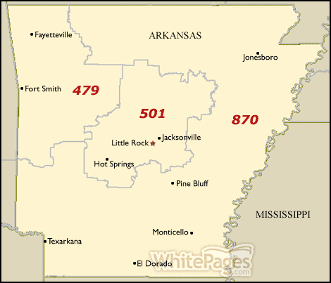
ARKANSAS AREA CODE MAP
ARKANSAS BLANK MAP

ARKANSAS COUNTIES MAP

Arkansas Unveiled: The Hidden Wonders of The Natural State
Please subscribe on "World Guide" channnel on Youtube at youtube.com/c/WorldGuide
The Earth, North America and Countries View from Space - Day Time and in the Night
All Arkansas Cities Maps by Population
Little Rock Map -
(193,524)
Fort Smith Map -
(86,209)
Fayetteville Map -
(73,580)
Springdale Map -
(69,797)
Jonesboro Map -
(67,263)
North Little Rock Map -
(62,304)
Conway Map -
(58,908)
Rogers Map -
(55,964)
Pine Bluff Map -
(49,083)
Bentonville Map -
(35,301)
Hot Springs Map -
(35,193)
Benton Map -
(30,681)
Texarkana Map -
(29,919)
Sherwood Map -
(29,523)
Jacksonville Map -
(28,364)
Russellville Map -
(27,920)
Bella Vista Map -
(26,461)
West Memphis Map -
(26,245)
Paragould Map -
(26,113)
Cabot Map -
(23,776)
Searcy Map -
(22,858)
Van Buren Map -
(22,791)
El Dorado Map -
(18,884)
Maumelle Map -
(17,163)
Bryant Map -
(16,688)
Blytheville Map -
(15,620)
Forrest City Map -
(15,371)
Siloam Springs Map -
(15,039)
Harrison Map -
(12,943)
Hot Springs Village Map -
(12,807)
Mountain Home Map -
(12,448)
Marion Map -
(12,345)
Helena West Helena Map -
(12,282)
Camden Map -
(12,183)
Magnolia Map -
(11,577)
Arkadelphia Map -
(10,714)
Malvern Map -
(10,318)
Batesville Map -
(10,248)
Hope Map -
(10,095)
Centerton Map -
(9,515)
Monticello Map -
(9,467)
Stuttgart Map -
(9,326)
Clarksville Map -
(9,178)
Greenwood Map -
(8,952)
Wynne Map -
(8,367)
Newport Map -
(7,879)
Osceola Map -
(7,757)
Lowell Map -
(7,327)
Beebe Map -
(7,315)
Trumann Map -
(7,243)
Heber Springs Map -
(7,165)
East End Map -
(6,998)
Morrilton Map -
(6,767)
Pocahontas Map -
(6,608)
De Queen Map -
(6,594)
Warren Map -
(6,003)
Farmington Map -
(5,974)
Mena Map -
(5,737)
White Hall Map -
(5,526)
Crossett Map -
(5,507)
Alma Map -
(5,419)
Berryville Map -
(5,356)
Walnut Ridge Map -
(4,890)
Pea Ridge Map -
(4,794)
Dardanelle Map -
(4,745)
Ashdown Map -
(4,723)
Dumas Map -
(4,706)
Greenbrier Map -
(4,706)
Piney Map -
(4,699)
Cherokee Village Map -
(4,671)
Barling Map -
(4,649)
Nashville Map -
(4,627)
Sheridan Map -
(4,603)
Prairie Grove Map -
(4,380)
Fordyce Map -
(4,300)
Lonoke Map -
(4,245)
McGehee Map -
(4,219)
Marianna Map -
(4,115)
Ward Map -
(4,067)
Haskell Map -
(3,990)
Booneville Map -
(3,990)
Piggott Map -
(3,849)
Vilonia Map -
(3,815)
Rockwell Map -
(3,780)
Ozark Map -
(3,684)
Waldron Map -
(3,618)
Landmark Map -
(3,555)
Gosnell Map -
(3,548)
Gibson Map -
(3,543)
Paris Map -
(3,532)
Corning Map -
(3,377)
Johnson Map -
(3,354)
Manila Map -
(3,342)
Prescott Map -
(3,296)
DeWitt Map -
(3,292)
Brinkley Map -
(3,188)
Gentry Map -
(3,158)
Shannon Hills Map -
(3,143)
North Crossett Map -
(3,119)
Atkins Map -
(3,016)
Alexander Map -
(2,901)
Bald Knob Map -
(2,897)
Hamburg Map -
(2,857)
Pottsville Map -
(2,838)
England Map -
(2,825)
Hoxie Map -
(2,780)
Green Forest Map -
(2,761)
Mountain View Map -
(2,748)
Elkins Map -
(2,648)
Salem Map -
(2,607)
Clinton Map -
(2,602)
Little Flock Map -
(2,585)
Lake Village Map -
(2,575)
Marked Tree Map -
(2,566)
Charleston Map -
(2,494)
Tontitown Map -
(2,460)
Earle Map -
(2,414)
Danville Map -
(2,409)
Holiday Island Map -
(2,373)
Bethel Heights Map -
(2,372)
Huntsville Map -
(2,346)
Fairfield Bay Map -
(2,338)
Gravette Map -
(2,325)
West Fork Map -
(2,317)
Dermott Map -
(2,316)
Lavaca Map -
(2,289)
Harrisburg Map -
(2,288)
Star City Map -
(2,274)
Eudora Map -
(2,269)
Lincoln Map -
(2,249)
Mayflower Map -
(2,234)
Glenwood Map -
(2,228)
Carlisle Map -
(2,214)
Gurdon Map -
(2,212)
Augusta Map -
(2,199)
Horseshoe Bend Map -
(2,184)
Lake Hamilton Map -
(2,135)
Bono Map -
(2,131)
Wrightsville Map -
(2,114)
Lake City Map -
(2,082)
Gassville Map -
(2,078)
Eureka Springs Map -
(2,073)
Prairie Creek Map -
(2,066)
Austin Map -
(2,038)
Judsonia Map -
(2,019)
Leachville Map -
(1,993)
Rector Map -
(1,977)
Bull Shoals Map -
(1,950)
Cave City Map -
(1,904)
Lepanto Map -
(1,893)
McAlmont Map -
(1,873)
Smackover Map -
(1,865)
Tuckerman Map -
(1,862)
Melbourne Map -
(1,848)
Bay Map -
(1,801)
McCrory Map -
(1,729)
Cave Springs Map -
(1,729)
Des Arc Map -
(1,717)
Decatur Map -
(1,699)
Stamps Map -
(1,693)
Clarendon Map -
(1,664)
Mulberry Map -
(1,655)
Kensett Map -
(1,648)
Brookland Map -
(1,642)
Murfreesboro Map -
(1,641)
Salem Map -
(1,635)
Lamar Map -
(1,605)
Calico Rock Map -
(1,545)
Elm Springs Map -
(1,535)
Monette Map -
(1,501)
Hazen Map -
(1,468)
Perryville Map -
(1,460)
Hughes Map -
(1,441)
Cedarville Map -
(1,394)
Dover Map -
(1,378)
Waldo Map -
(1,372)
Flippin Map -
(1,355)
Marshall Map -
(1,355)
Rison Map -
(1,344)
Hampton Map -
(1,324)
Diaz Map -
(1,318)
Redfield Map -
(1,297)
Ola Map -
(1,281)
Lewisville Map -
(1,280)
Caraway Map -
(1,279)
Greenland Map -
(1,259)
West Crossett Map -
(1,256)
Mineral Springs Map -
(1,208)
Yellville Map -
(1,204)
Marvell Map -
(1,186)
Luxora Map -
(1,178)
Newark Map -
(1,176)
Mansfield Map -
(1,139)
Dierks Map -
(1,133)
Marmaduke Map -
(1,111)
Parkin Map -
(1,105)
Sulphur Springs Map -
(1,101)
Midway Map -
(1,084)
Ash Flat Map -
(1,082)
Mount Ida Map -
(1,076)
Goshen Map -
(1,071)
Highland Map -
(1,045)
Horatio Map -
(1,044)
London Map -
(1,039)
Coal Hill Map -
(1,012)
Foreman Map -
(1,011)
Altheimer Map -
(984)
Tumbling Shoals Map -
(978)
Mammoth Spring Map -
(977)
Cotter Map -
(970)
Bearden Map -
(966)
Kibler Map -
(961)
East Camden Map -
(931)
Wilson Map -
(903)
Avilla Map -
(896)
Greers Ferry Map -
(891)
Stephens Map -
(891)
Oak Grove Heights Map -
(889)
Dyer Map -
(876)
Wooster Map -
(860)
Fouke Map -
(859)
Sweet Home Map -
(849)
Magazine Map -
(847)
Norphlet Map -
(844)
Gould Map -
(837)
Hermitage Map -
(830)
Plumerville Map -
(826)
Hackett Map -
(812)
Swifton Map -
(798)
Kirby Map -
(786)
Diamond City Map -
(782)
Oppelo Map -
(781)
Hardy Map -
(772)
Mountain Pine Map -
(770)
Madison Map -
(769)
Cammack Village Map -
(768)
Quitman Map -
(762)
Tyronza Map -
(762)
Bradford Map -
(759)
Keiser Map -
(759)
Altus Map -
(758)
Rockport Map -
(755)
Wickes Map -
(754)
Roland Map -
(746)
Lakeview Map -
(741)
Lockesburg Map -
(739)
Knoxville Map -
(731)
Amity Map -
(723)
Weiner Map -
(716)
Guy Map -
(708)
Gillett Map -
(691)
McRae Map -
(682)
Palestine Map -
(681)
Imboden Map -
(677)
Oxford Map -
(670)
Black Rock Map -
(662)
Cherry Valley Map -
(651)
Cotton Plant Map -
(649)
Hartford Map -
(642)
Elaine Map -
(636)
Caddo Valley Map -
(635)
Huntington Map -
(635)
Mountainburg Map -
(631)
Bradley Map -
(628)
Higginson Map -
(621)
De Valls Bluff Map -
(619)
Turrell Map -
(615)
Plainview Map -
(608)
Summit Map -
(604)
Holly Grove Map -
(602)
Pangburn Map -
(601)
College Station Map -
(600)
Huttig Map -
(597)
Highfill Map -
(583)
Junction City Map -
(581)
Joiner Map -
(576)
Bonanza Map -
(575)
Subiaco Map -
(572)
Taylor Map -
(566)
Strong Map -
(558)
Holland Map -
(557)
Humphrey Map -
(557)
Caldwell Map -
(555)
Grannis Map -
(554)
Wilmot Map -
(550)
Dennard Map -
(530)
Hartman Map -
(519)
Emmet Map -
(518)
Traskwood Map -
(518)
McNeil Map -
(516)
Norfork Map -
(511)
Wilmar Map -
(511)
Sulphur Springs Map -
(511)
Fountain Lake Map -
(503)
Central City Map -
(502)
Garfield Map -
(502)
Leola Map -
(501)
Hiwasse Map -
(497)
Calion Map -
(494)
Avoca Map -
(488)
Yarborough Landing Map -
(487)
Bauxite Map -
(487)
Rose Bud Map -
(482)
Crawfordsville Map -
(479)
Ravenden Map -
(470)
Jasper Map -
(466)
Lafe Map -
(458)
Sulphur Rock Map -
(456)
Reyno Map -
(456)
College City Map -
(455)
Bellefonte Map -
(454)
Cushman Map -
(452)
Patterson Map -
(452)
Hector Map -
(450)
Salesville Map -
(450)
Grady Map -
(449)
Tull Map -
(448)
Kingsland Map -
(447)
Lake View Map -
(443)
Leslie Map -
(441)
Belleville Map -
(441)
Bergman Map -
(439)
Portia Map -
(437)
Lost Bridge Village Map -
(434)
Evening Shade Map -
(432)
Portland Map -
(430)
Edmondson Map -
(427)
Sparkman Map -
(427)
Maynard Map -
(426)
Natural Steps Map -
(426)
Mount Pleasant Map -
(414)
Hatfield Map -
(413)
Dyess Map -
(410)
Thornton Map -
(407)
Gateway Map -
(405)
Woodson Map -
(403)
Alpena Map -
(392)
Winslow Map -
(391)
Midway Map -
(389)
Center Ridge Map -
(388)
Grubbs Map -
(386)
Western Grove Map -
(384)
Damascus Map -
(382)
Cove Map -
(382)
Colt Map -
(378)
Norman Map -
(378)
Havana Map -
(375)
Wilton Map -
(374)
Clarkedale Map -
(371)
Oak Grove Map -
(369)
Emerson Map -
(368)
Branch Map -
(367)
Arkansas City Map -
(366)
Fredonia (Biscoe) Map -
(363)
Mitchellville Map -
(360)
Wheatley Map -
(355)
Montrose Map -
(354)
Etowah Map -
(351)
Pleasant Plains Map -
(349)
Biggers Map -
(347)
Carthage Map -
(343)
Cash Map -
(342)
Enola Map -
(338)
Viola Map -
(337)
Twin Groves Map -
(335)
Midland Map -
(325)
Blevins Map -
(315)
Bigelow Map -
(315)
Denning Map -
(314)
Prattsville Map -
(305)
Strawberry Map -
(302)
Menifee Map -
(302)
Donaldson Map -
(301)
Horseshoe Lake Map -
(292)
Shirley Map -
(291)
Poyen Map -
(290)
Lynn Map -
(288)
Knobel Map -
(287)
Chidester Map -
(287)
Lexa Map -
(286)
Humnoke Map -
(284)
Garner Map -
(284)
Almyra Map -
(283)
Delight Map -
(279)
Parkdale Map -
(277)
Buckner Map -
(275)
Widener Map -
(273)
Perrytown Map -
(272)
Hickory Ridge Map -
(272)
Lead Hill Map -
(271)
Perry Map -
(270)
Black Oak Map -
(262)
Rosston Map -
(261)
Oil Trough Map -
(260)
Keo Map -
(256)
Letona Map -
(255)
Campbell Station Map -
(255)
Wabbaseka Map -
(255)
Harrell Map -
(254)
St. Francis Map -
(250)
Concord Map -
(244)
Garland Map -
(242)
Perla Map -
(241)
Tollette Map -
(240)
Pineville Map -
(238)
Briarcliff Map -
(236)
Oden Map -
(232)
St. Charles Map -
(230)
Griffithville Map -
(225)
Tillar Map -
(225)
Scranton Map -
(224)
Dell Map -
(223)
Fisher Map -
(223)
Pollard Map -
(222)
Pyatt Map -
(221)
Moro Map -
(216)
Russell Map -
(216)
Caulksville Map -
(213)
Jacksonport Map -
(212)
Watson Map -
(211)
Woodlawn Map -
(209)
Greenway Map -
(209)
Adona Map -
(209)
Ratcliff Map -
(202)
Magness Map -
(202)
Fulton Map -
(201)
Sunset Map -
(198)
Franklin Map -
(198)
Rondo Map -
(198)
O'Kean Map -
(194)
Winthrop Map -
(192)
Burdette Map -
(191)
Gilmore Map -
(188)
McDougal Map -
(186)
West Point Map -
(185)
Valley Springs Map -
(183)
Sidney Map -
(181)
Ogden Map -
(180)
Tupelo Map -
(180)
Washington Map -
(180)
Friendship Map -
(176)
Fountain Hill Map -
(175)
New Blaine Map -
(174)
Bassett Map -
(173)
Fifty Six Map -
(173)
Houston Map -
(173)
Casa Map -
(171)
Ulm Map -
(170)
Aubrey Map -
(170)
Omaha Map -
(169)
Winchester Map -
(167)
Louann Map -
(164)
Anthonyville Map -
(161)
Gillham Map -
(160)
Chester Map -
(159)
Sedgwick Map -
(152)
Willisville Map -
(152)
Haynes Map -
(150)
Felsenthal Map -
(150)
Success Map -
(149)
Okolona Map -
(147)
Rye Map -
(146)
Ben Lomond Map -
(145)
Mount Vernon Map -
(145)
Reed Map -
(141)
Hensley Map -
(139)
Bodcaw Map -
(138)
Moorefield Map -
(137)
Peach Orchard Map -
(135)
Everton Map -
(133)
St. Joe Map -
(132)
Maysville Map -
(130)
Hagarville Map -
(129)
New Edinburg Map -
(127)
Blue Mountain Map -
(124)
Alicia Map -
(124)
Banks Map -
(124)
Georgetown Map -
(124)
Bluff City Map -
(124)
Higden Map -
(120)
Gum Springs Map -
(120)
Jericho Map -
(119)
Ravenden Springs Map -
(118)
Antoine Map -
(117)
Staves Map -
(116)
Delaplaine Map -
(116)
Daisy Map -
(115)
Allport Map -
(115)
Jennette Map -
(115)
Roe Map -
(114)
St. Paul Map -
(113)
Pindall Map -
(112)
Egypt Map -
(112)
Minturn Map -
(109)
Beedeville Map -
(107)
Big Flat Map -
(105)
Hunter Map -
(105)
Zinc Map -
(103)
South Lead Hill Map -
(102)
Datto Map -
(100)
Beaver Map -
(100)
Black Springs Map -
(99)
Fargo Map -
(98)
Amagon Map -
(98)
McCaskill Map -
(96)
Coy Map -
(96)
Lonsdale Map -
(94)
Whelen Springs Map -
(92)
LaGrange Map -
(89)
Vandervoort Map -
(87)
Springtown Map -
(87)
Guion Map -
(86)
Ozan Map -
(85)
Marie Map -
(84)
Sherrill Map -
(84)
Cale Map -
(79)
Smithville Map -
(78)
Weldon Map -
(75)
Williford Map -
(75)
Cherokee City Map -
(72)
Powhatan Map -
(72)
Scott Map -
(72)
Corinth Map -
(70)
Nimmons Map -
(69)
McNab Map -
(68)
Reader Map -
(66)
Patmos Map -
(64)
Morrison Bluff Map -
(64)
Oakhaven Map -
(63)
Fourche Map -
(62)
Rudy Map -
(61)
Waldenburg Map -
(61)
Hindsville Map -
(61)
Tinsman Map -
(54)
Birdsong Map -
(41)
Jerome Map -
(39)
Wiederkehr Village Map -
(38)
Victoria Map -
(37)
Blue Eye Map -
(30)
Gilbert Map -
(28)
Magnet Cove Map -
(5)