With interactive Wisconsin Map, view regional highways maps, road situations, transportation, lodging guide, geographical map, physical maps and more information. On Wisconsin Map, you can view all states, regions, cities, towns, districts, avenues, streets and popular centers' satellite, sketch and terrain maps.
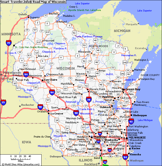
ROAD MAP OF WISCONSIN
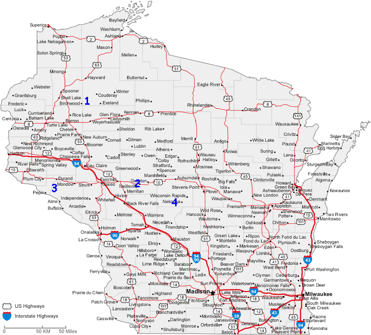
WISCONSIN CITIES MAP
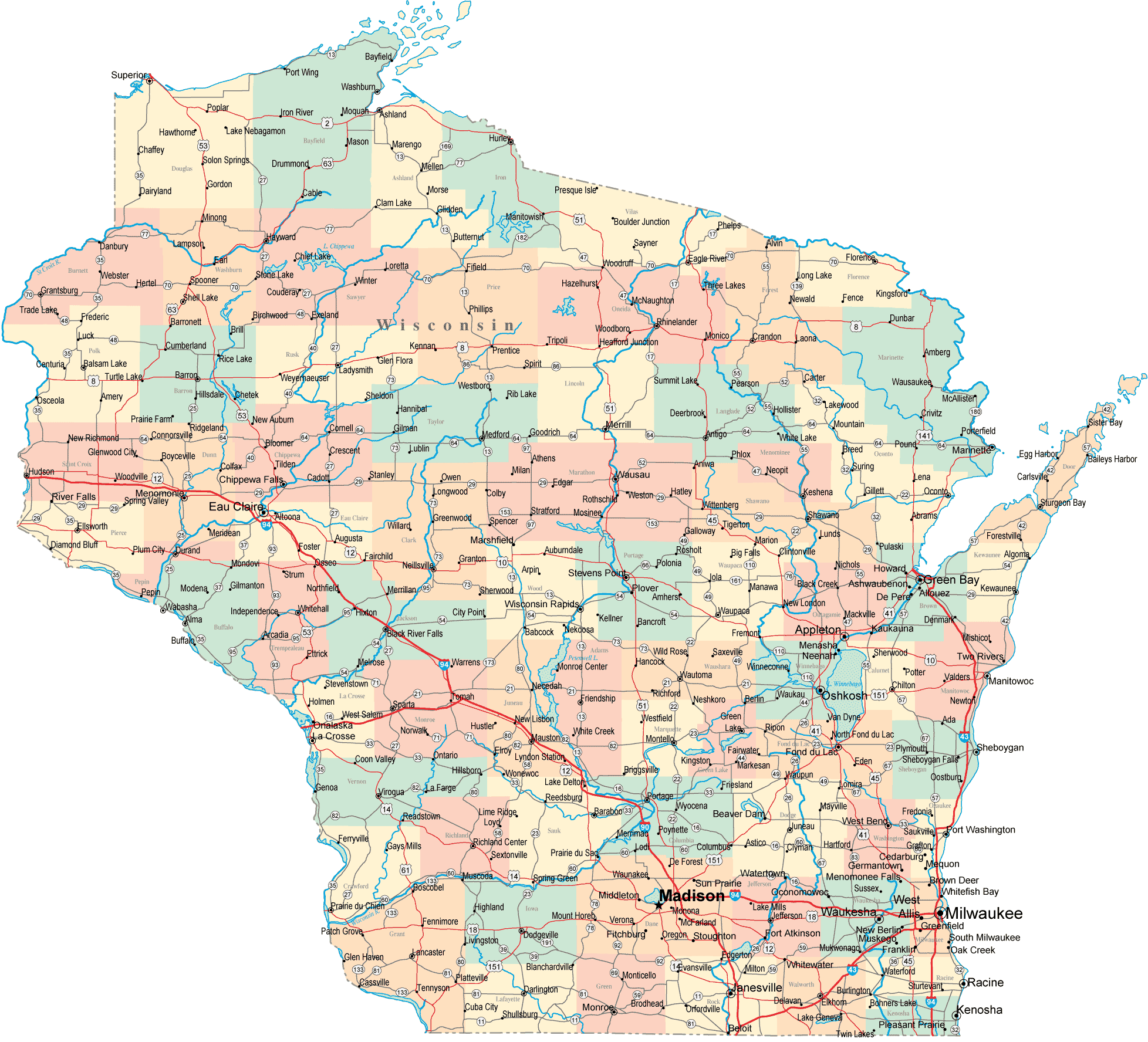
WISCONSIN MAP
All Wisconsin Cities Maps by Population
Milwaukee Map -
(594,833)
Madison Map -
(233,209)
Green Bay Map -
(104,057)
Kenosha Map -
(99,218)
Racine Map -
(78,860)
Appleton Map -
(72,623)
Waukesha Map -
(70,718)
Oshkosh Map -
(66,083)
Eau Claire Map -
(65,883)
Janesville Map -
(63,575)
West Allis Map -
(60,411)
La Crosse Map -
(51,320)
Sheboygan Map -
(49,288)
Wauwatosa Map -
(46,396)
Fond du Lac Map -
(43,021)
New Berlin Map -
(39,584)
Wausau Map -
(39,106)
Brookfield Map -
(37,920)
Beloit Map -
(36,966)
Greenfield Map -
(36,720)
Menomonee Falls Map -
(35,626)
Franklin Map -
(35,451)
Oak Creek Map -
(34,451)
Manitowoc Map -
(33,736)
West Bend Map -
(31,078)
Sun Prairie Map -
(29,364)
Superior Map -
(27,244)
Stevens Point Map -
(26,717)
Mount Pleasant Map -
(26,197)
Neenah Map -
(25,501)
Fitchburg Map -
(25,260)
Caledonia Map -
(24,705)
Muskego Map -
(24,135)
Watertown Map -
(23,861)
De Pere Map -
(23,800)
Mequon Map -
(23,132)
South Milwaukee Map -
(21,156)
Germantown Map -
(19,749)
Pleasant Prairie Map -
(19,719)
Marshfield Map -
(19,118)
Wisconsin Rapids Map -
(18,367)
Cudahy Map -
(18,267)
Onalaska Map -
(17,736)
Middleton Map -
(17,442)
Howard Map -
(17,399)
Menasha Map -
(17,353)
Ashwaubenon Map -
(16,963)
Menomonie Map -
(16,264)
Beaver Dam Map -
(16,214)
Oconomowoc Map -
(15,759)
Kaukauna Map -
(15,462)
River Falls Map -
(15,000)
Weston Map -
(14,868)
Bellevue Map -
(14,570)
Whitewater Map -
(14,390)
Hartford Map -
(14,223)
Whitefish Bay Map -
(14,110)
Greendale Map -
(14,046)
Allouez Map -
(13,975)
Chippewa Falls Map -
(13,661)
Pewaukee Map -
(13,195)
Shorewood Map -
(13,162)
Glendale Map -
(12,872)
Hudson Map -
(12,719)
Stoughton Map -
(12,611)
Fort Atkinson Map -
(12,368)
Plover Map -
(12,123)
Waunakee Map -
(12,097)
Baraboo Map -
(12,048)
Brown Deer Map -
(11,999)
Two Rivers Map -
(11,712)
Grafton Map -
(11,459)
Cedarburg Map -
(11,412)
Suamico Map -
(11,346)
Waupun Map -
(11,340)
Richfield Map -
(11,300)
Port Washington Map -
(11,250)
Platteville Map -
(11,224)
Marinette Map -
(10,968)
Monroe Map -
(10,827)
Verona Map -
(10,619)
Sussex Map -
(10,518)
Burlington Map -
(10,464)
Little Chute Map -
(10,449)
Portage Map -
(10,324)
Elkhorn Map -
(10,084)
Merrill Map -
(9,661)
Sparta Map -
(9,522)
St. Francis Map -
(9,365)
Shawano Map -
(9,305)
Oregon Map -
(9,231)
Reedsburg Map -
(9,200)
Sturgeon Bay Map -
(9,144)
Hartland Map -
(9,110)
Tomah Map -
(9,093)
Holmen Map -
(9,005)
DeForest Map -
(8,936)
Delavan Map -
(8,463)
Plymouth Map -
(8,445)
Rice Lake Map -
(8,438)
New Richmond Map -
(8,375)
Antigo Map -
(8,234)
Ashland Map -
(8,216)
Pewaukee Map -
(8,166)
Jefferson Map -
(7,973)
McFarland Map -
(7,808)
Rhinelander Map -
(7,798)
Sheboygan Falls Map -
(7,775)
Ripon Map -
(7,733)
Hales Corners Map -
(7,692)
Lake Geneva Map -
(7,651)
Monona Map -
(7,533)
Mukwonago Map -
(7,355)
New London Map -
(7,295)
Kronenwetter Map -
(7,210)
Delafield Map -
(7,085)
Mount Horeb Map -
(7,009)
Sturtevant Map -
(6,970)
Jackson Map -
(6,753)
Altoona Map -
(6,706)
Fox Point Map -
(6,701)
Kimberly Map -
(6,468)
Lake Hallie Map -
(6,448)
Cottage Grove Map -
(6,192)
Hobart Map -
(6,182)
Waupaca Map -
(6,069)
Twin Lakes Map -
(5,989)
Elm Grove Map -
(5,934)
Prairie du Chien Map -
(5,911)
Lake Mills Map -
(5,708)
Rib Mountain Map -
(5,651)
Milton Map -
(5,546)
Berlin Map -
(5,524)
Edgerton Map -
(5,461)
Waterford Map -
(5,368)
Wind Lake Map -
(5,342)
Rothschild Map -
(5,269)
Richland Center Map -
(5,184)
Mayville Map -
(5,154)
Tichigan Map -
(5,133)
Slinger Map -
(5,068)
North Fond du Lac Map -
(5,014)
Evansville Map -
(5,012)
Columbus Map -
(4,991)
Union Grove Map -
(4,915)
West Salem Map -
(4,799)
Dodgeville Map -
(4,693)
Clintonville Map -
(4,559)
Oconto Map -
(4,513)
Saukville Map -
(4,451)
Mauston Map -
(4,423)
Okauchee Lake Map -
(4,422)
Bayside Map -
(4,389)
Viroqua Map -
(4,362)
Medford Map -
(4,326)
East Troy Map -
(4,281)
Prescott Map -
(4,258)
French Island Map -
(4,207)
West Milwaukee Map -
(4,206)
Lake Map -
(4,189)
Kewaskum Map -
(4,004)
Mosinee Map -
(3,988)
Prairie du Sac Map -
(3,972)
Baldwin Map -
(3,957)
Chilton Map -
(3,933)
Lancaster Map -
(3,868)
Marshall Map -
(3,862)
North Hudson Map -
(3,768)
Kiel Map -
(3,738)
Pell Lake Map -
(3,722)
Rochester Map -
(3,682)
Camp Lake Map -
(3,665)
Horicon Map -
(3,655)
Black River Falls Map -
(3,622)
Stanley Map -
(3,608)
Windsor Map -
(3,573)
Bloomer Map -
(3,539)
Pulaski Map -
(3,539)
Cross Plains Map -
(3,538)
Omro Map -
(3,517)
Peshtigo Map -
(3,502)
Seymour Map -
(3,451)
Barron Map -
(3,423)
Ladysmith Map -
(3,414)
Sauk City Map -
(3,410)
Tomahawk Map -
(3,397)
Merton Map -
(3,346)
Waterloo Map -
(3,333)
Combined Locks Map -
(3,328)
Brodhead Map -
(3,293)
Ellsworth Map -
(3,284)
New Holstein Map -
(3,236)
Thiensville Map -
(3,235)
Boscobel Map -
(3,231)
Howards Grove Map -
(3,188)
Algoma Map -
(3,167)
Brillion Map -
(3,148)
Lodi Map -
(3,050)
Genoa City Map -
(3,042)
Paddock Lake Map -
(2,992)
Kewaunee Map -
(2,952)
Arcadia Map -
(2,925)
Lake Delton Map -
(2,914)
Amery Map -
(2,902)
Oconto Falls Map -
(2,891)
Oostburg Map -
(2,887)
Wrightstown Map -
(2,827)
Walworth Map -
(2,816)
Juneau Map -
(2,814)
Mondovi Map -
(2,777)
Johnson Creek Map -
(2,738)
Lake Wissota Map -
(2,738)
Sherwood Map -
(2,713)
Hortonville Map -
(2,711)
Spooner Map -
(2,682)
Wisconsin Dells Map -
(2,678)
Lake Wazeecha Map -
(2,651)
Delavan Lake Map -
(2,649)
Somerset Map -
(2,635)
Como Map -
(2,631)
Bristol Map -
(2,584)
Nekoosa Map -
(2,580)
Osceola Map -
(2,568)
Williams Bay Map -
(2,564)
New Lisbon Map -
(2,554)
Wales Map -
(2,549)
Poynette Map -
(2,528)
Luxemburg Map -
(2,515)
Fennimore Map -
(2,497)
Mineral Point Map -
(2,487)
Neillsville Map -
(2,463)
Park Falls Map -
(2,462)
Darlington Map -
(2,451)
Bohners Lake Map -
(2,444)
Lomira Map -
(2,430)
Silver Lake Map -
(2,411)
Belleville Map -
(2,385)
Winneconne Map -
(2,383)
Deerfield Map -
(2,319)
Hayward Map -
(2,318)
Abbotsford Map -
(2,310)
Dousman Map -
(2,302)
Belgium Map -
(2,245)
Tainter Lake Map -
(2,242)
Chetek Map -
(2,221)
Wautoma Map -
(2,218)
Westby Map -
(2,200)
New Glarus Map -
(2,172)
Cumberland Map -
(2,170)
Schofield Map -
(2,169)
Fredonia Map -
(2,160)
Clinton Map -
(2,154)
Redgranite Map -
(2,149)
North Prairie Map -
(2,141)
St. Croix Falls Map -
(2,133)
Denmark Map -
(2,123)
Kohler Map -
(2,120)
Washburn Map -
(2,117)
Pardeeville Map -
(2,115)
Cedar Grove Map -
(2,113)
Cuba City Map -
(2,086)
Browns Lake Map -
(2,039)
Campbellsport Map -
(2,016)
Lac du Flambeau Map -
(1,969)
Adams Map -
(1,967)
Eagle Map -
(1,950)
Durand Map -
(1,931)
Spencer Map -
(1,925)
Hammond Map -
(1,922)
Crandon Map -
(1,920)
Weyauwega Map -
(1,900)
Brice Prairie Map -
(1,887)
Colby Map -
(1,852)
Butler Map -
(1,841)
Port Edwards Map -
(1,818)
Randolph Map -
(1,811)
Cameron Map -
(1,783)
Palmyra Map -
(1,781)
Lake Ripley Map -
(1,779)
King Map -
(1,750)
Whiting Map -
(1,724)
Wind Point Map -
(1,723)
Fall River Map -
(1,712)
Osseo Map -
(1,701)
Fontana on Geneva Lake Map -
(1,672)
Mazomanie Map -
(1,652)
Roberts Map -
(1,651)
Spring Green Map -
(1,628)
Niagara Map -
(1,624)
Ixonia Map -
(1,624)
Thorp Map -
(1,621)
Powers Lake Map -
(1,615)
Sharon Map -
(1,605)
River Hills Map -
(1,597)
Random Lake Map -
(1,594)
Darien Map -
(1,580)
Stratford Map -
(1,578)
Shorewood Hills Map -
(1,565)
Whitehall Map -
(1,558)
Augusta Map -
(1,550)
Hurley Map -
(1,547)
Trempealeau Map -
(1,529)
Legend Lake Map -
(1,525)
Marathon City Map -
(1,524)
Fox Lake Map -
(1,519)
Montello Map -
(1,495)
St. Peter Map -
(1,489)
Cleveland Map -
(1,485)
Galesville Map -
(1,481)
Edgar Map -
(1,479)
Bonduel Map -
(1,478)
Phillips Map -
(1,478)
Markesan Map -
(1,476)
Cornell Map -
(1,467)
Bangor Map -
(1,459)
Cambridge Map -
(1,457)
Elroy Map -
(1,442)
Mishicot Map -
(1,442)
Orfordville Map -
(1,442)
Cadott Map -
(1,437)
Seymour Map -
(1,418)
Hillsboro Map -
(1,417)
West Baraboo Map -
(1,414)
Brooklyn Map -
(1,401)
Eagle River Map -
(1,398)
Nashotah Map -
(1,395)
Gillett Map -
(1,386)
Manawa Map -
(1,371)
Blair Map -
(1,366)
Spring Valley Map -
(1,352)
Shell Lake Map -
(1,347)
Woodville Map -
(1,344)
Grantsburg Map -
(1,341)
Black Earth Map -
(1,338)
Independence Map -
(1,336)
Black Creek Map -
(1,316)
Fall Creek Map -
(1,315)
Maple Bluff Map -
(1,313)
Iola Map -
(1,301)
Muscoda Map -
(1,299)
Big Bend Map -
(1,290)
Theresa Map -
(1,262)
Keshena Map -
(1,262)
Loyal Map -
(1,261)
Marion Map -
(1,260)
Hazel Green Map -
(1,256)
Newburg Map -
(1,254)
Westfield Map -
(1,254)
Glenwood City Map -
(1,242)
Barneveld Map -
(1,231)
Shullsburg Map -
(1,226)
Monticello Map -
(1,217)
Princeton Map -
(1,214)
Reedsville Map -
(1,206)
Lake Koshkonong Map -
(1,204)
Eagle Lake Map -
(1,192)
Lauderdale Lakes Map -
(1,172)
Colfax Map -
(1,158)
Frederic Map -
(1,137)
Hilbert Map -
(1,132)
Hustisford Map -
(1,123)
Luck Map -
(1,119)
Strum Map -
(1,114)
Potter Lake Map -
(1,107)
Lannon Map -
(1,107)
Athens Map -
(1,105)
Cashton Map -
(1,102)
Boyceville Map -
(1,086)
Little Round Lake Map -
(1,081)
Wittenberg Map -
(1,081)
Oakfield Map -
(1,075)
Clear Lake Map -
(1,070)
Lake Nebagamon Map -
(1,069)
Rosendale Map -
(1,063)
Dickeyville Map -
(1,061)
Rio Map -
(1,059)
Turtle Lake Map -
(1,050)
Amherst Map -
(1,035)
Greenwood Map -
(1,026)
Buffalo City Map -
(1,023)
Albany Map -
(1,018)
Balsam Lake Map -
(1,009)
Dane Map -
(995)
Belmont Map -
(986)
Crivitz Map -
(984)
Chain O' Lakes Map -
(981)
Benton Map -
(973)
Elkhart Lake Map -
(967)
Woodruff Map -
(966)
Butte des Morts Map -
(962)
Valders Map -
(962)
Green Lake Map -
(960)
Centuria Map -
(948)
Cassville Map -
(947)
Owen Map -
(940)
Iron Ridge Map -
(929)
Shiocton Map -
(921)
Milltown Map -
(917)
Necedah Map -
(916)
Rib Lake Map -
(910)
Dresser Map -
(895)
Lone Rock Map -
(888)
Hingham Map -
(886)
Brandon Map -
(879)
Elk Mound Map -
(878)
Sister Bay Map -
(876)
Dorchester Map -
(876)
Eden Map -
(875)
Pittsville Map -
(874)
Plainfield Map -
(862)
Lake Shangrila Map -
(861)
Fountain City Map -
(859)
Argyle Map -
(857)
Blue Mounds Map -
(855)
Highland Map -
(842)
Biron Map -
(839)
Lake Arrowhead Map -
(838)
Pepin Map -
(837)
Arena Map -
(834)
Hewitt Map -
(828)
Lake Camelot Map -
(826)
Blanchardville Map -
(825)
Allenton Map -
(823)
Arlington Map -
(819)
Birnamwood Map -
(818)
Elmwood Map -
(817)
Wonewoc Map -
(816)
Footville Map -
(808)
Montreal Map -
(807)
Siren Map -
(806)
St. Nazianz Map -
(783)
Alma Map -
(781)
Bruce Map -
(779)
Stoddard Map -
(774)
Plain Map -
(773)
Wyocena Map -
(768)
Cambria Map -
(767)
Coon Valley Map -
(765)
Mount Calvary Map -
(762)
Iron River Map -
(761)
Whitelaw Map -
(757)
La Farge Map -
(746)
Bluffview Map -
(742)
Tigerton Map -
(741)
Bloomington Map -
(735)
Mellen Map -
(731)
Wild Rose Map -
(725)
Friendship Map -
(725)
Coleman Map -
(724)
Montfort Map -
(718)
Wauzeka Map -
(711)
Cascade Map -
(709)
Reeseville Map -
(708)
Taycheedah Map -
(704)
Auburndale Map -
(703)
North Freedom Map -
(701)
Viola Map -
(699)
Neopit Map -
(690)
Rome Map -
(689)
Potosi Map -
(688)
Fremont Map -
(679)
Almena Map -
(677)
Winchester Map -
(671)
Eleva Map -
(670)
Sullivan Map -
(669)
Francis Creek Map -
(669)
Superior Map -
(664)
Livingston Map -
(664)
Prentice Map -
(660)
Waubeka Map -
(657)
Webster Map -
(653)
Ridgeway Map -
(653)
Norwalk Map -
(638)
Avoca Map -
(637)
Stockbridge Map -
(636)
Forest Junction Map -
(616)
Oxford Map -
(607)
Greenleaf Map -
(607)
Three Lakes Map -
(605)
Poplar Map -
(603)
Camp Douglas Map -
(601)
Solon Springs Map -
(600)
Plum City Map -
(599)
Oconomowoc Lake Map -
(595)
Rockland Map -
(594)
Soldiers Grove Map -
(592)
Florence Map -
(592)
Chenequa Map -
(590)
Gresham Map -
(586)
Vesper Map -
(584)
Casco Map -
(583)
Chief Lake Map -
(583)
Laona Map -
(583)
Brownsville Map -
(581)
Wabeno Map -
(575)
Wausaukee Map -
(575)
Hatley Map -
(574)
Neosho Map -
(574)
Clayton Map -
(571)
Cecil Map -
(570)
Lena Map -
(564)
Delwood Map -
(563)
Star Prairie Map -
(561)
Ontario Map -
(554)
Boyd Map -
(552)
Sextonville Map -
(551)
Fairchild Map -
(550)
Linden Map -
(549)
New Auburn Map -
(548)
Suring Map -
(544)
Merrillan Map -
(542)
Stetsonville Map -
(541)
Dyckesville Map -
(538)
Bancroft Map -
(535)
Dale Map -
(528)
Minong Map -
(527)
Polonia Map -
(526)
Ettrick Map -
(524)
Adell Map -
(516)
Mercer Map -
(516)
Gibbsville Map -
(512)
Glidden Map -
(507)
Rosholt Map -
(506)
Wilton Map -
(504)
Alma Center Map -
(503)
Melrose Map -
(503)
St. Joseph Map -
(503)
Waldo Map -
(503)
Bay City Map -
(500)
Lyndon Station Map -
(500)
Elmwood Park Map -
(497)
Kieler Map -
(497)
Northport Map -
(491)
Gays Mills Map -
(491)
Park Ridge Map -
(491)
South Wayne Map -
(489)
Withee Map -
(487)
Bayfield Map -
(487)
St. Cloud Map -
(477)
Lily Lake Map -
(477)
Taylor Map -
(476)
Prairie Farm Map -
(473)
New Odanah Map -
(472)
Kendall Map -
(472)
Endeavor Map -
(468)
Knapp Map -
(463)
Glenbeulah Map -
(463)
Cobb Map -
(458)
Minocqua Map -
(451)
Cochrane Map -
(450)
Coloma Map -
(450)
Almond Map -
(448)
Bear Creek Map -
(448)
Wilmot Map -
(442)
Birchwood Map -
(442)
Junction City Map -
(439)
Rudolph Map -
(439)
Mattoon Map -
(438)
Mole Lake Map -
(435)
Lake Ivanhoe Map -
(435)
Blue River Map -
(434)
Neshkoro Map -
(434)
Hixton Map -
(433)
Forestville Map -
(430)
Reserve Map -
(429)
Eastman Map -
(428)
Clyman Map -
(422)
Merrimac Map -
(420)
Hancock Map -
(417)
Readstown Map -
(415)
Pigeon Falls Map -
(411)
Gilman Map -
(410)
Dallas Map -
(409)
Embarrass Map -
(404)
Lohrville Map -
(402)
Oliver Map -
(399)
Houlton Map -
(386)
Bagley Map -
(379)
Pound Map -
(377)
Amherst Junction Map -
(377)
Butternut Map -
(375)
Post Lake Map -
(374)
Nelson Map -
(374)
Lake Sherwood Map -
(372)
Poy Sippi Map -
(371)
Fairwater Map -
(371)
La Valle Map -
(367)
Scandinavia Map -
(363)
Mountain Map -
(363)
Warrens Map -
(363)
White Lake Map -
(363)
Rock Springs Map -
(362)
Juda Map -
(357)
Friesland Map -
(356)
Granton Map -
(355)
Tennyson Map -
(355)
Krakow Map -
(354)
Maribel Map -
(351)
Wheeler Map -
(348)
Turtle Lake Map -
(343)
Unity Map -
(343)
Abrams Map -
(340)
Lowell Map -
(340)
Elcho Map -
(339)
Hager City Map -
(338)
Arpin Map -
(333)
Ashippun Map -
(333)
Kellnersville Map -
(332)
Kingston Map -
(326)
Lake Lorraine Map -
(324)
Lakewood Map -
(323)
Cazenovia Map -
(318)
Winter Map -
(313)
Sandy Hook Map -
(309)
New Post Map -
(305)
Hawkins Map -
(305)
Bowler Map -
(302)
Loganville Map -
(300)
Doylestown Map -
(297)
Oakdale Map -
(297)
Birch Hill Map -
(293)
Rewey Map -
(292)
Lac La Belle Map -
(290)
Hollandale Map -
(288)
Ephraim Map -
(288)
De Soto Map -
(287)
Haugen Map -
(287)
Chaseburg Map -
(284)
Middle Village Map -
(281)
Browntown Map -
(280)
Van Dyne Map -
(279)
Milladore Map -
(276)
Nichols Map -
(273)
Ridgeland Map -
(273)
Goodman Map -
(271)
Caroline Map -
(270)
Holcombe Map -
(267)
Humbird Map -
(266)
Downing Map -
(265)
Packwaukee Map -
(262)
Aniwa Map -
(260)
Sobieski Map -
(259)
Baileys Harbor Map -
(257)
Burnett Map -
(256)
Waukau Map -
(255)
Brule Map -
(254)
Ironton Map -
(253)
Genoa Map -
(253)
Potter Map -
(253)
Brokaw Map -
(251)
Helenville Map -
(249)
North Bay Map -
(241)
Radisson Map -
(241)
Weyerhaeuser Map -
(238)
Jim Falls Map -
(237)
Sheldon Map -
(237)
Gratiot Map -
(236)
Lake Tomahawk Map -
(228)
Trego Map -
(227)
Chili Map -
(226)
Mount Hope Map -
(225)
Hebron Map -
(224)
Eureka Map -
(220)
Curtiss Map -
(216)
Deer Park Map -
(216)
Rockdale Map -
(214)
Mount Sterling Map -
(211)
Sayner Map -
(207)
Dalton Map -
(206)
Cable Map -
(206)
Lebanon Map -
(204)
Eland Map -
(202)
Egg Harbor Map -
(201)
Union Center Map -
(200)
Patch Grove Map -
(198)
Exeland Map -
(196)
Diamond Bluff Map -
(194)
Hustler Map -
(194)
Pembine Map -
(193)
Gotham Map -
(191)
Westboro Map -
(190)
Cataract Map -
(186)
Ogema Map -
(186)
Pella Map -
(185)
Ogdensburg Map -
(185)
Wilson Map -
(184)
Boulder Junction Map -
(183)
Hanover Map -
(181)
Amberg Map -
(180)
Elderon Map -
(179)
Stone Lake Map -
(178)
Arkansaw Map -
(177)
Navarino Map -
(177)
Ferryville Map -
(176)
Gordon Map -
(176)
Iron Belt Map -
(173)
Edmund Map -
(173)
Danbury Map -
(172)
Ellison Bay Map -
(165)
Collins Map -
(164)
Lewis Map -
(164)
Port Wing Map -
(164)
Grand View Map -
(163)
Lime Ridge Map -
(162)
Greenbush Map -
(162)
Kekoskee Map -
(161)
Emerald Map -
(161)
Argonne Map -
(160)
Springfield Map -
(158)
Arkdale Map -
(158)
Boaz Map -
(156)
Nelsonville Map -
(155)
Franks Field Map -
(154)
Drummond Map -
(154)
Fenwood Map -
(152)
Marquette Map -
(150)
Wyeville Map -
(147)
Pine River Map -
(147)
Downsville Map -
(146)
Townsend Map -
(146)
Summit Lake Map -
(144)
Hatfield Map -
(141)
Little Sturgeon Map -
(136)
Kennan Map -
(135)
Pulcifer Map -
(134)
Green Valley Map -
(133)
Woodman Map -
(132)
Lynxville Map -
(132)
Steuben Map -
(131)
Pence Map -
(131)
Grand Marsh Map -
(127)
Babcock Map -
(126)
Millston Map -
(125)
Dodge Map -
(121)
Knowlton Map -
(120)
Maiden Rock Map -
(119)
Lublin Map -
(118)
Bell Center Map -
(117)
Tustin Map -
(117)
Chelsea Map -
(113)
Tony Map -
(113)
Marengo Map -
(111)
Barronett Map -
(111)
Catawba Map -
(110)
Tunnel City Map -
(106)
Whittlesey Map -
(105)
Herbster Map -
(104)
Melvina Map -
(104)
Zoar Map -
(98)
Cornucopia Map -
(98)
Newald Map -
(95)
Conrath Map -
(95)
Mason Map -
(93)
Angelica Map -
(92)
Glen Flora Map -
(92)
Tilleda Map -
(91)
Saxon Map -
(90)
Couderay Map -
(88)
Leopolis Map -
(87)
Ingram Map -
(78)
Yuba Map -
(74)
Glen Haven Map -
(73)
Diaperville Map -
(70)
Woodford Map -
(69)
Waumandee Map -
(68)
Stockholm Map -
(66)
Thornton Map -
(65)
Big Falls Map -
(61)
Jump River Map -
(52)
Long Lake Map -
(50)
Dunbar Map -
(50)
Clam Lake Map -
(37)
Odanah Map -
(13)