With interactive Idaho Map, view regional highways maps, road situations, transportation, lodging guide, geographical map, physical maps and more information. On Idaho Map, you can view all states, regions, cities, towns, districts, avenues, streets and popular centers' satellite, sketch and terrain maps.
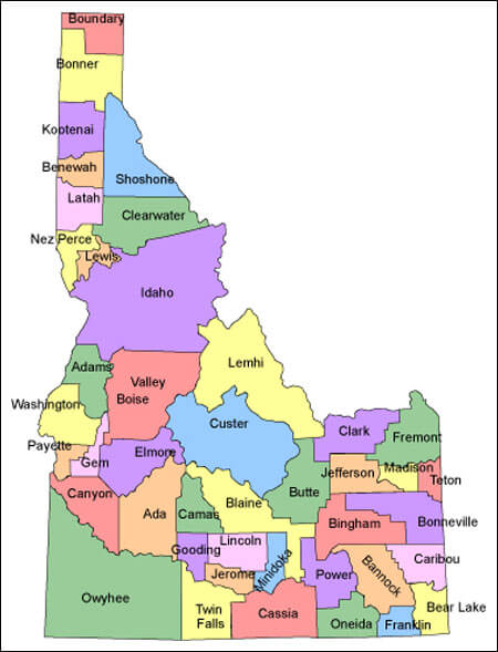
ID COUNTIES MAP
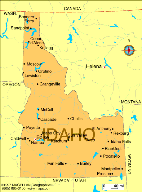
IDAHO CITIES MAP
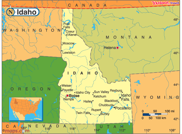
IDAHO POLITICAL MAP
All Idaho Cities Maps by Population
Boise City Map -
(205,671)
Nampa Map -
(81,557)
Meridian Map -
(75,092)
Idaho Falls Map -
(56,813)
Pocatello Map -
(54,255)
Caldwell Map -
(46,237)
Coeur d'Alene Map -
(44,137)
Twin Falls Map -
(44,125)
Lewiston Map -
(31,894)
Post Falls Map -
(27,574)
Rexburg Map -
(25,484)
Moscow Map -
(23,800)
Eagle Map -
(19,908)
Kuna Map -
(15,210)
Mountain Home Map -
(14,206)
Chubbuck Map -
(13,922)
Ammon Map -
(13,816)
Hayden Map -
(13,294)
Blackfoot Map -
(11,899)
Garden City Map -
(10,972)
Jerome Map -
(10,890)
Burley Map -
(10,345)
Hailey Map -
(7,960)
Payette Map -
(7,433)
Sandpoint Map -
(7,365)
Rathdrum Map -
(6,826)
Emmett Map -
(6,557)
Star Map -
(5,793)
Rupert Map -
(5,554)
Middleton Map -
(5,524)
Weiser Map -
(5,507)
Preston Map -
(5,204)
Fruitland Map -
(4,684)
American Falls Map -
(4,457)
Shelley Map -
(4,409)
Buhl Map -
(4,122)
Rigby Map -
(3,945)
Lincoln Map -
(3,647)
Gooding Map -
(3,567)
St. Anthony Map -
(3,542)
Kimberly Map -
(3,264)
Mountain Home AFB Map -
(3,238)
Fort Hall Map -
(3,201)
Orofino Map -
(3,142)
Grangeville Map -
(3,141)
Salmon Map -
(3,112)
Heyburn Map -
(3,089)
Soda Springs Map -
(3,058)
McCall Map -
(2,991)
Wendell Map -
(2,782)
Ketchum Map -
(2,689)
Homedale Map -
(2,633)
Montpelier Map -
(2,597)
Bonners Ferry Map -
(2,543)
Filer Map -
(2,508)
St. Maries Map -
(2,402)
Dalton Gardens Map -
(2,335)
Bellevue Map -
(2,287)
Hidden Spring Map -
(2,280)
Kellogg Map -
(2,120)
Malad City Map -
(2,095)
Aberdeen Map -
(1,994)
Parma Map -
(1,983)
Spirit Lake Map -
(1,945)
Victor Map -
(1,928)
Iona Map -
(1,803)
Priest River Map -
(1,751)
Driggs Map -
(1,660)
Pinehurst Map -
(1,619)
Osburn Map -
(1,555)
New Plymouth Map -
(1,538)
Wilder Map -
(1,533)
Sugar City Map -
(1,514)
Shoshone Map -
(1,461)
Sun Valley Map -
(1,406)
Glenns Ferry Map -
(1,319)
Kamiah Map -
(1,295)
Moreland Map -
(1,278)
Paul Map -
(1,169)
Robie Creek Map -
(1,162)
Hansen Map -
(1,144)
Lapwai Map -
(1,137)
Ponderay Map -
(1,137)
Ashton Map -
(1,127)
Tyhee Map -
(1,123)
Ucon Map -
(1,108)
Challis Map -
(1,081)
Plummer Map -
(1,044)
Marsing Map -
(1,031)
Arco Map -
(995)
Genesee Map -
(955)
Cascade Map -
(939)
Grace Map -
(915)
Cottonwood Map -
(900)
Groveland Map -
(877)
Hagerman Map -
(872)
Troy Map -
(862)
Inkom Map -
(854)
Greenleaf Map -
(846)
Council Map -
(839)
Riverside Map -
(838)
McCammon Map -
(809)
Potlatch Map -
(804)
Wallace Map -
(784)
Oakley Map -
(763)
Hazelton Map -
(753)
Menan Map -
(741)
Teton Map -
(735)
Moyie Springs Map -
(718)
Horseshoe Bend Map -
(707)
Mullan Map -
(692)
Athol Map -
(692)
Hauser Map -
(678)
Kootenai Map -
(678)
Dubois Map -
(677)
Ririe Map -
(656)
Franklin Map -
(641)
Smelterville Map -
(627)
Downey Map -
(625)
Kooskia Map -
(607)
Carey Map -
(604)
Arbon Valley Map -
(599)
Roberts Map -
(580)
Juliaetta Map -
(579)
Hayden Lake Map -
(574)
Dover Map -
(556)
Clark Fork Map -
(536)
Notus Map -
(531)
Mackay Map -
(517)
Melba Map -
(513)
Paris Map -
(513)
Pierce Map -
(508)
Deary Map -
(506)
Craigmont Map -
(501)
New Meadows Map -
(496)
Idaho City Map -
(485)
Richfield Map -
(482)
Firth Map -
(477)
Georgetown Map -
(476)
Nezperce Map -
(466)
Dayton Map -
(463)
Lewisville Map -
(458)
Grand View Map -
(452)
Weippe Map -
(441)
Weston Map -
(437)
Riggins Map -
(419)
Fairfield Map -
(416)
Lava Hot Springs Map -
(407)
Eden Map -
(405)
Garden Valley Map -
(394)
Basalt Map -
(394)
Culdesac Map -
(380)
Bancroft Map -
(377)
Mud Lake Map -
(358)
Arimo Map -
(355)
Declo Map -
(343)
Winchester Map -
(340)
Dietrich Map -
(332)
Cambridge Map -
(328)
Newdale Map -
(323)
Bliss Map -
(318)
Parker Map -
(305)
Kendrick Map -
(303)
Rockland Map -
(295)
Island Park Map -
(286)
Rockford Map -
(276)
Hollister Map -
(272)
Tetonia Map -
(269)
Albion Map -
(267)
Blanchard Map -
(261)
Bovill Map -
(260)
Clifton Map -
(259)
Worley Map -
(257)
Castleford Map -
(226)
Stites Map -
(221)
Irwin Map -
(219)
East Hope Map -
(210)
Bloomington Map -
(206)
Swan Valley Map -
(204)
Harrison Map -
(203)
Elk City Map -
(202)
Peck Map -
(197)
Malta Map -
(193)
Bennington Map -
(190)
Moore Map -
(189)
Wardner Map -
(188)
Onaway Map -
(187)
Rockford Bay Map -
(184)
Oldtown Map -
(184)
De Smet Map -
(175)
Midvale Map -
(171)
Fernan Lake Village Map -
(169)
Crouch Map -
(162)
Ferdinand Map -
(159)
Donnelly Map -
(152)
Princeton Map -
(148)
Sweetwater Map -
(143)
St. Charles Map -
(131)
Elk River Map -
(125)
Acequia Map -
(124)
Tensed Map -
(123)
Murtaugh Map -
(115)
Minidoka Map -
(112)
Leadore Map -
(105)
Huetter Map -
(100)
Murphy Map -
(97)
White Bird Map -
(91)
Hope Map -
(86)
Parkline Map -
(80)
Smiths Ferry Map -
(75)
Butte City Map -
(74)
Reubens Map -
(71)
Lost River Map -
(68)
Stanley Map -
(63)
Placerville Map -
(53)
Hamer Map -
(48)
Oxford Map -
(48)
Conkling Park Map -
(43)
Lowman Map -
(42)
State Line Map -
(38)
Spencer Map -
(37)
Yellow Pine Map -
(32)
Atomic City Map -
(29)
Banks Map -
(17)
Drummond Map -
(16)
Clayton Map -
(7)
Warm River Map -
(3)