With interactive Massachusetts Map, view regional highways maps, road situations, transportation, lodging guide, geographical map, physical maps and more information. On Massachusetts Map, you can view all states, regions, cities, towns, districts, avenues, streets and popular centers' satellite, sketch and terrain maps.
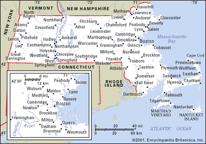
CITIES MAP OF MASSACHUSETTS
Exploring Boston's Top 10 Must-Visit Attractions
Please subscribe on "World Guide" channnel on Youtube at youtube.com/c/WorldGuide
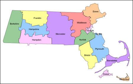
COUNTIES MAP OF MASSACHUSETTS
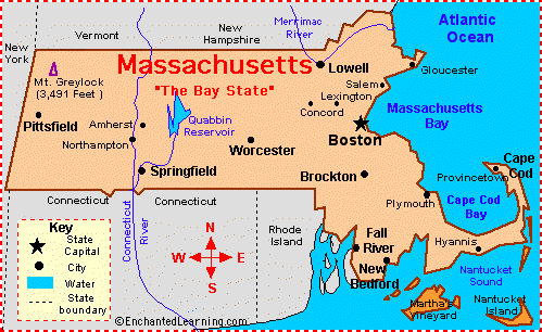
MAPS OF MASSACHUSETTS
All Massachusetts Cities Maps by Population
Boston Map -
(617,594)
Worcester Map -
(181,045)
Springfield Map -
(153,060)
Lowell Map -
(106,519)
Cambridge Map -
(105,162)
New Bedford Map -
(95,072)
Brockton Map -
(93,810)
Quincy Map -
(92,271)
Lynn Map -
(90,329)
Fall River Map -
(88,857)
Newton Map -
(85,146)
Lawrence Map -
(76,377)
Somerville Map -
(75,754)
Framingham Map -
(68,318)
Haverhill Map -
(60,879)
Waltham Map -
(60,632)
Malden Map -
(59,450)
Brookline Map -
(58,732)
Medford Map -
(56,173)
Taunton Map -
(55,874)
Chicopee Map -
(55,298)
Weymouth Town Map -
(53,743)
Revere Map -
(51,755)
Peabody Map -
(51,251)
Methuen Town Map -
(47,255)
Barnstable Town Map -
(45,193)
Pittsfield Map -
(44,737)
Attleboro Map -
(43,593)
Arlington Map -
(42,844)
Everett Map -
(41,667)
Salem Map -
(41,340)
Westfield Map -
(41,094)
Leominster Map -
(40,759)
Fitchburg Map -
(40,318)
Holyoke Map -
(39,880)
Beverly Map -
(39,502)
Marlborough Map -
(38,499)
Woburn Map -
(38,120)
Braintree Town Map -
(35,744)
Chelsea Map -
(35,177)
Randolph Map -
(32,112)
Watertown Town Map -
(31,915)
Franklin Town Map -
(31,635)
Lexington Map -
(31,394)
Needham Map -
(28,886)
Gloucester Map -
(28,789)
Norwood Map -
(28,602)
Northampton Map -
(28,549)
Agawam Town Map -
(28,438)
West Springfield Town Map -
(28,391)
Wellesley Map -
(27,982)
Milton Map -
(27,003)
Melrose Map -
(26,983)
Saugus Map -
(26,628)
Danvers Map -
(26,493)
Milford Map -
(25,055)
Wakefield Map -
(24,932)
Reading Map -
(24,747)
Dedham Map -
(24,729)
Belmont Map -
(24,729)
Burlington Map -
(24,498)
Wilmington Map -
(22,325)
Stoneham Map -
(21,437)
Winchester Map -
(21,374)
Gardner Map -
(20,228)
Marblehead Map -
(19,808)
Amherst Center Map -
(19,065)
Somerset Map -
(18,165)
Winthrop Town Map -
(17,497)
Greenfield Town Map -
(17,456)
Newburyport Map -
(17,416)
Southbridge Town Map -
(16,719)
Amesbury Town Map -
(16,283)
Easthampton Town Map -
(16,053)
Abington Map -
(15,985)
Longmeadow Map -
(15,784)
Hudson Map -
(14,907)
Swampscott Map -
(13,787)
North Adams Map -
(13,708)
Palmer Town Map -
(12,140)
Lynnfield Map -
(11,596)
Webster Map -
(11,412)
South Yarmouth Map -
(11,092)
Holbrook Map -
(10,791)
Hull Map -
(10,293)
Maynard Map -
(10,106)
Andover Map -
(8,762)
Athol Map -
(8,265)
Bridgewater Map -
(7,841)
Plymouth Map -
(7,494)
Nantucket Map -
(7,446)
Clinton Map -
(7,389)
Mansfield Center Map -
(7,360)
Middleborough Center Map -
(7,319)
Pinehurst Map -
(7,152)
North Amherst Map -
(6,819)
Whitinsville Map -
(6,704)
Cochituate Map -
(6,569)
Medfield Map -
(6,483)
Ware Map -
(6,170)
Northborough Map -
(6,167)
Oxford Map -
(6,103)
East Falmouth Map -
(6,038)
West Concord Map -
(6,028)
West Yarmouth Map -
(6,012)
Walpole Map -
(5,918)
Spencer Map -
(5,700)
Sharon Map -
(5,658)
Hingham Map -
(5,650)
Foxborough Map -
(5,625)
Kingston Map -
(5,591)
Adams Map -
(5,515)
Yarmouth Port Map -
(5,320)
Bliss Corner Map -
(5,280)
Scituate Map -
(5,245)
North Scituate Map -
(5,077)
South Amherst Map -
(4,994)
Ocean Bluff Brant Rock Map -
(4,970)
Rockport Map -
(4,966)
East Harwich Map -
(4,872)
Salisbury Map -
(4,869)
Bellingham Map -
(4,854)
Smith Mills Map -
(4,760)
North Westport Map -
(4,571)
Turners Falls Map -
(4,470)
Millis Clicquot Map -
(4,403)
Marshfield Map -
(4,335)
Williamstown Map -
(4,325)
Ipswich Map -
(4,222)
Winchendon Map -
(4,213)
Raynham Center Map -
(4,100)
Forestdale Map -
(4,099)
Westborough Map -
(4,045)
Orange Map -
(4,018)
East Sandwich Map -
(3,940)
Northwest Harwich Map -
(3,929)
Wilbraham Map -
(3,915)
Buzzards Bay Map -
(3,859)
Falmouth Map -
(3,799)
Hopedale Map -
(3,753)
South Dennis Map -
(3,643)
Sagamore Map -
(3,623)
North Plymouth Map -
(3,600)
Nahant Map -
(3,410)
South Duxbury Map -
(3,360)
North Pembroke Map -
(3,292)
Dennis Port Map -
(3,162)
North Falmouth Map -
(3,084)
Acushnet Center Map -
(3,073)
Upton Map -
(3,013)
Sandwich Map -
(2,962)
Mattapoisett Center Map -
(2,915)
Belchertown Map -
(2,899)
Wareham Center Map -
(2,896)
Ayer Map -
(2,868)
Pocasset Map -
(2,851)
Ocean Grove Map -
(2,811)
Monument Beach Map -
(2,790)
Littleton Common Map -
(2,789)
East Dennis Map -
(2,753)
Topsfield Map -
(2,717)
Norton Center Map -
(2,671)
Cordaville Map -
(2,650)
North Seekonk Map -
(2,643)
Provincetown Map -
(2,642)
North Lakeville Map -
(2,630)
Green Harbor Cedar Crest Map -
(2,609)
Fiskdale Map -
(2,583)
East Douglas Map -
(2,557)
Hopkinton Map -
(2,550)
Pepperell Map -
(2,504)
Dennis Map -
(2,407)
Marshfield Hills Map -
(2,356)
Boxford Map -
(2,339)
Dover Map -
(2,265)
North Brookfield Map -
(2,265)
Sturbridge Map -
(2,253)
West Dennis Map -
(2,242)
Great Barrington Map -
(2,231)
Hanson Map -
(2,118)
Vineyard Haven Map -
(2,114)
Rutland Map -
(2,111)
Monson Center Map -
(2,107)
White Island Shores Map -
(2,106)
Weweantic Map -
(2,105)
West Wareham Map -
(2,064)
East Pepperell Map -
(2,059)
Lee Map -
(2,051)
Baldwinville Map -
(2,028)
Brewster Map -
(2,000)
South Lancaster Map -
(1,894)
South Deerfield Map -
(1,880)
Devens Map -
(1,840)
North Eastham Map -
(1,806)
Duxbury Map -
(1,802)
Harwich Center Map -
(1,798)
Lunenburg Map -
(1,760)
West Falmouth Map -
(1,738)
Shelburne Falls Map -
(1,731)
Teaticket Map -
(1,692)
Lenox Map -
(1,675)
Harwich Port Map -
(1,644)
Orleans Map -
(1,621)
Onset Map -
(1,573)
Essex Map -
(1,471)
Holland Map -
(1,464)
Shirley Map -
(1,441)
Chatham Map -
(1,421)
Bourne Map -
(1,418)
Rowley Map -
(1,416)
West Brookfield Map -
(1,413)
West Chatham Map -
(1,410)
Warren Map -
(1,405)
Granby Map -
(1,368)
East Brookfield Map -
(1,323)
Hatfield Map -
(1,318)
Millers Falls Map -
(1,139)
Townsend Map -
(1,128)
Groton Map -
(1,124)
Marion Center Map -
(1,111)
Housatonic Map -
(1,109)
Northfield Map -
(1,089)
South Ashburnham Map -
(1,062)
Barre Map -
(1,009)
Mashpee Neck Map -
(1,000)
The Pinehills Map -
(955)
Huntington Map -
(936)
Brookfield Map -
(833)
Russell Map -
(786)
Woods Hole Map -
(781)
New Seabury Map -
(717)
Deerfield Map -
(643)
Chester Map -
(627)
Cheshire Map -
(514)
Seabrook Map -
(455)
Blandford Map -
(393)
Petersham Map -
(243)
Madaket Map -
(236)
Popponesset Map -
(220)
Siasconset Map -
(205)
Monomoscoy Island Map -
(147)
Seconsett Island Map -
(100)
Popponesset Island Map -
(26)
Southfield Map -