With interactive Tennessee Map, view regional highways maps, road situations, transportation, lodging guide, geographical map, physical maps and more information. On Tennessee Map, you can view all states, regions, cities, towns, districts, avenues, streets and popular centers' satellite, sketch and terrain maps.
MAP OF TENNESSEE
TENNESSEE MAP
TENNESSEE MAPS
All Tennessee Cities Maps by Population
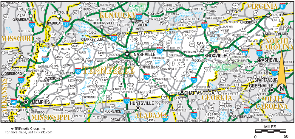
Memphis Map -
(646,889)
Nashville Map -
(601,222)
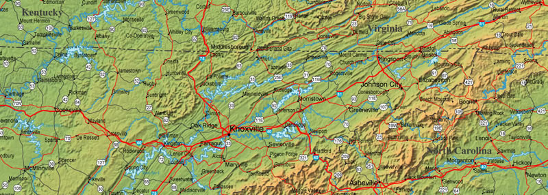
Knoxville Map -
(178,874)
Chattanooga Map -
(167,674)
Clarksville Map -
(132,929)
Murfreesboro Map -
(108,755)
Jackson Map -
(65,211)
Johnson City Map -
(63,152)
Franklin Map -
(62,487)
Bartlett Map -
(54,613)
Hendersonville Map -
(51,372)
Kingsport Map -
(48,205)
Collierville Map -
(43,965)
Cleveland Map -
(41,285)
Smyrna Map -
(39,974)
Germantown Map -
(38,844)
Brentwood Map -
(37,060)
Columbia Map -
(34,681)
La Vergne Map -
(32,588)
Cookeville Map -
(30,435)
Gallatin Map -
(30,278)
Oak Ridge Map -
(29,330)
Morristown Map -
(29,137)
Spring Hill Map -
(29,036)
Maryville Map -
(27,465)
Bristol Map -
(26,702)
Lebanon Map -
(26,190)
Mount Juliet Map -
(23,671)
East Ridge Map -
(20,979)
Farragut Map -
(20,676)
Shelbyville Map -
(20,335)
Tullahoma Map -
(18,655)
Dyersburg Map -
(17,145)
Springfield Map -
(16,440)
Goodlettsville Map -
(15,921)
Greeneville Map -
(15,062)
Sevierville Map -
(14,807)
Dickson Map -
(14,538)
Elizabethton Map -
(14,176)
McMinnville Map -
(13,605)
Athens Map -
(13,458)
Soddy Daisy Map -
(12,714)
Middle Valley Map -
(12,684)
Lakeland Map -
(12,430)
Red Bank Map -
(11,651)
Arlington Map -
(11,517)
Portland Map -
(11,480)
Martin Map -
(11,473)
Lewisburg Map -
(11,100)
Seymour Map -
(10,919)
Union City Map -
(10,895)
Crossville Map -
(10,795)
Lawrenceburg Map -
(10,428)
Brownsville Map -
(10,292)
White House Map -
(10,255)
Millington Map -
(10,176)
Paris Map -
(10,156)
Manchester Map -
(10,102)
Bloomingdale Map -
(9,888)
Clinton Map -
(9,841)
Covington Map -
(9,038)
Lenoir City Map -
(8,642)
Winchester Map -
(8,530)
Humboldt Map -
(8,452)
Alcoa Map -
(8,449)
Ripley Map -
(8,445)
Atoka Map -
(8,387)
Collegedale Map -
(8,282)
Jefferson City Map -
(8,047)
Pulaski Map -
(7,870)
Milan Map -
(7,851)
Harrison Map -
(7,769)
Fairview Map -
(7,720)
Lexington Map -
(7,652)
Signal Mountain Map -
(7,554)
La Follette Map -
(7,456)
Dayton Map -
(7,191)
Fairfield Glade Map -
(6,989)
Savannah Map -
(6,982)
Newport Map -
(6,945)
Colonial Heights Map -
(6,934)
South Cleveland Map -
(6,912)
Fayetteville Map -
(6,827)
Church Hill Map -
(6,737)
Oakland Map -
(6,623)
Green Hill Map -
(6,618)
Millersville Map -
(6,440)
Greenbrier Map -
(6,433)
Lynchburg Map -
(6,362)
Harriman Map -
(6,350)
Henderson Map -
(6,309)
Erwin Map -
(6,097)
Kingston Map -
(5,934)
Munford Map -
(5,927)
Pigeon Forge Map -
(5,875)
Nolensville Map -
(5,861)
Tellico Village Map -
(5,791)
Sweetwater Map -
(5,764)
Rockwood Map -
(5,562)
Mount Carmel Map -
(5,429)
Bolivar Map -
(5,417)
Loudon Map -
(5,381)
McKenzie Map -
(5,310)
Eagleton Village Map -
(5,052)
Jonesborough Map -
(5,051)
Sparta Map -
(4,925)
Dunlap Map -
(4,815)
Forest Hills Map -
(4,812)
Whiteville Map -
(4,638)
Madisonville Map -
(4,577)
Mount Pleasant Map -
(4,561)
Ashland City Map -
(4,541)
Smithville Map -
(4,530)
Oak Hill Map -
(4,529)
Lafayette Map -
(4,474)
Tiptonville Map -
(4,464)
Oak Grove Map -
(4,425)
Rogersville Map -
(4,420)
Selmer Map -
(4,396)
Harrogate Map -
(4,389)
Coopertown Map -
(4,278)
Trenton Map -
(4,264)
Pleasant View Map -
(4,149)
Waverly Map -
(4,105)
Livingston Map -
(4,058)
Huntingdon Map -
(3,985)
Spurgeon Map -
(3,957)
Gatlinburg Map -
(3,944)
Lake Tansi Map -
(3,803)
Hohenwald Map -
(3,757)
Oneida Map -
(3,752)
Centerville Map -
(3,644)
Unicoi Map -
(3,632)
Camden Map -
(3,582)
Algood Map -
(3,495)
Etowah Map -
(3,490)
Medina Map -
(3,479)
Newbern Map -
(3,313)
Jasper Map -
(3,279)
Oliver Springs Map -
(3,231)
White Bluff Map -
(3,206)
Wildwood Lake Map -
(3,124)
Somerville Map -
(3,094)
Blountville Map -
(3,074)
New Tazewell Map -
(3,037)
Dresden Map -
(3,005)
South Pittsburg Map -
(2,992)
Belle Meade Map -
(2,912)
Monterey Map -
(2,850)
Sale Creek Map -
(2,845)
Shackle Island Map -
(2,844)
Bean Station Map -
(2,826)
Fairmount Map -
(2,825)
Dandridge Map -
(2,812)
Kingston Springs Map -
(2,756)
Brighton Map -
(2,735)
Clifton Map -
(2,694)
Woodbury Map -
(2,680)
Tusculum Map -
(2,663)
Mountain City Map -
(2,531)
Apison Map -
(2,469)
Coalfield Map -
(2,463)
Alamo Map -
(2,461)
Waynesboro Map -
(2,449)
Park City Map -
(2,442)
Louisville Map -
(2,439)
Bells Map -
(2,437)
Maynardville Map -
(2,413)
Mascot Map -
(2,411)
Walnut Hill Map -
(2,394)
Pine Crest Map -
(2,388)
Parsons Map -
(2,373)
Mosheim Map -
(2,362)
Decherd Map -
(2,361)
Jellico Map -
(2,355)
South Fulton Map -
(2,354)
Dyer Map -
(2,341)
Sewanee Map -
(2,311)
Carthage Map -
(2,306)
Lakewood Map -
(2,302)
Caryville Map -
(2,297)
Central Map -
(2,279)
Halls Map -
(2,255)
Tazewell Map -
(2,218)
Adamsville Map -
(2,207)
Westmoreland Map -
(2,206)
White Pine Map -
(2,196)
Thompson's Station Map -
(2,194)
Greenfield Map -
(2,182)
Plainview Map -
(2,125)
Pegram Map -
(2,093)
Estill Springs Map -
(2,055)
Jacksboro Map -
(2,020)
Rural Hill Map -
(2,007)
Spring City Map -
(1,981)
Jamestown Map -
(1,959)
New Johnsonville Map -
(1,951)
Walden Map -
(1,898)
Ridgetop Map -
(1,874)
Hopewell Map -
(1,874)
Blaine Map -
(1,856)
Hunter Map -
(1,854)
Lookout Mountain Map -
(1,832)
Lakesite Map -
(1,826)
Gruetli Laager Map -
(1,813)
Surgoinsville Map -
(1,801)
Ridgely Map -
(1,795)
Lake City Map -
(1,781)
McEwen Map -
(1,750)
Cowan Map -
(1,737)
Bluff City Map -
(1,733)
Loretto Map -
(1,714)
Cross Plains Map -
(1,714)
Three Way Map -
(1,709)
Whitwell Map -
(1,699)
Fincastle Map -
(1,618)
Mowbray Mountain Map -
(1,615)
Mason Map -
(1,609)
Pikeville Map -
(1,608)
East Cleveland Map -
(1,608)
Spencer Map -
(1,601)
Decatur Map -
(1,598)
Englewood Map -
(1,532)
Graysville Map -
(1,502)
Banner Hill Map -
(1,497)
Celina Map -
(1,495)
Norris Map -
(1,491)
Tracy City Map -
(1,481)
Bruceton Map -
(1,478)
Watertown Map -
(1,477)
Vonore Map -
(1,474)
Burns Map -
(1,468)
Gleason Map -
(1,445)
Chapel Hill Map -
(1,445)
Piperton Map -
(1,445)
New Union Map -
(1,431)
Crump Map -
(1,428)
Dover Map -
(1,417)
Kimball Map -
(1,395)
Sneedville Map -
(1,387)
Benton Map -
(1,385)
Troy Map -
(1,371)
Tennessee Ridge Map -
(1,368)
Unionville Map -
(1,368)
Baxter Map -
(1,365)
Midtown Map -
(1,360)
Roan Mountain Map -
(1,360)
Olivet Map -
(1,350)
New Market Map -
(1,334)
Erin Map -
(1,324)
Powells Crossroads Map -
(1,322)
South Carthage Map -
(1,322)
Fall Branch Map -
(1,291)
Kenton Map -
(1,281)
Huntsville Map -
(1,248)
Charlotte Map -
(1,235)
Falling Water Map -
(1,232)
Bon Aqua Junction Map -
(1,230)
Gray Map -
(1,222)
Gordonsville Map -
(1,213)
Ardmore Map -
(1,213)
Lone Oak Map -
(1,206)
Cornersville Map -
(1,194)
Monteagle Map -
(1,192)
Grimsley Map -
(1,167)
Rutherford Map -
(1,151)
Rutledge Map -
(1,122)
Obion Map -
(1,119)
Red Boiling Springs Map -
(1,112)
Wildwood Map -
(1,098)
New Hope Map -
(1,082)
Luttrell Map -
(1,074)
Dodson Branch Map -
(1,074)
Greenback Map -
(1,064)
Bradford Map -
(1,048)
Altamont Map -
(1,045)
Lakewood Park Map -
(990)
Scotts Hill Map -
(984)
Collinwood Map -
(982)
Winfield Map -
(967)
Alexandria Map -
(966)
Gainesboro Map -
(962)
Henning Map -
(945)
Sharon Map -
(944)
Mooresburg Map -
(941)
Atwood Map -
(938)
Telford Map -
(921)
Wartburg Map -
(918)
Friendsville Map -
(913)
Linden Map -
(908)
Lobelville Map -
(897)
Tellico Plains Map -
(880)
Huntland Map -
(872)
Decaturville Map -
(867)
Summertown Map -
(866)
Helenwood Map -
(865)
Walnut Grove Map -
(864)
Trezevant Map -
(859)
Orlinda Map -
(859)
Rockford Map -
(856)
Coalmont Map -
(841)
Byrdstown Map -
(803)
St. Joseph Map -
(782)
Crab Orchard Map -
(752)
Bulls Gap Map -
(738)
Lyles Map -
(734)
Niota Map -
(719)
Bethel Springs Map -
(718)
Hollow Rock Map -
(718)
Middleton Map -
(706)
Eastview Map -
(705)
Morrison Map -
(694)
Ooltewah Map -
(687)
Gallaway Map -
(680)
Maury City Map -
(674)
Palmer Map -
(672)
Puryear Map -
(671)
Riceville Map -
(670)
Friendship Map -
(668)
Rossville Map -
(664)
Philadelphia Map -
(656)
Wartrace Map -
(651)
Charleston Map -
(651)
Gates Map -
(647)
Trimble Map -
(637)
Allardt Map -
(634)
Adams Map -
(633)
Flintville Map -
(627)
Eagleville Map -
(604)
Michie Map -
(591)
Petros Map -
(583)
Elkton Map -
(578)
Clarkrange Map -
(575)
Pleasant Hill Map -
(563)
Big Sandy Map -
(557)
Moscow Map -
(556)
Castalian Springs Map -
(556)
Sunbright Map -
(552)
Petersburg Map -
(544)
Minor Hill Map -
(537)
Doyle Map -
(537)
Berry Hill Map -
(537)
Fairgarden Map -
(529)
Pittman Center Map -
(502)
Bell Buckle Map -
(500)
Cumberland Gap Map -
(494)
Calhoun Map -
(490)
Baneberry Map -
(482)
Beersheba Springs Map -
(477)
Gilt Edge Map -
(477)
Ducktown Map -
(475)
Andersonville Map -
(472)
Gadsden Map -
(470)
Chesterfield Map -
(469)
Guys Map -
(466)
Ethridge Map -
(465)
Henry Map -
(464)
Watauga Map -
(458)
Stanton Map -
(452)
Hillsboro Map -
(450)
Townsend Map -
(448)
Baileyton Map -
(431)
Burlison Map -
(425)
Hornbeak Map -
(424)
Flat Top Mountain Map -
(422)
Pelham Map -
(403)
Walterhill Map -
(401)
Darden Map -
(399)
Walnut Grove Map -
(396)
Gibson Map -
(396)
Williston Map -
(395)
Vanleer Map -
(395)
Clarksburg Map -
(393)
Ridgeside Map -
(390)
Sardis Map -
(381)
Woodland Mills Map -
(378)
New Deal Map -
(368)
Cottontown Map -
(367)
Toone Map -
(364)
Dowelltown Map -
(355)
Copperhill Map -
(354)
McLemoresville Map -
(352)
Parker's Crossroads Map -
(330)
Iron City Map -
(328)
Rives Map -
(326)
Grand Junction Map -
(325)
Ramer Map -
(319)
Cedar Hill Map -
(314)
Cumberland City Map -
(311)
Garland Map -
(310)
Liberty Map -
(310)
Hornsby Map -
(303)
Saltillo Map -
(303)
Bowman Map -
(302)
Finger Map -
(298)
Eva Map -
(293)
Bethpage Map -
(288)
Robbins Map -
(287)
Lynnville Map -
(287)
Yorkville Map -
(286)
Stantonville Map -
(283)
Elgin Map -
(282)
Braden Map -
(282)
Wrigley Map -
(281)
Auburntown Map -
(269)
Milledgeville Map -
(265)
Parrottsville Map -
(263)
Walland Map -
(259)
Centertown Map -
(243)
Graball Map -
(236)
Oak Grove Map -
(231)
Samburg Map -
(217)
Oakdale Map -
(212)
Mitchellville Map -
(189)
Enville Map -
(189)
Slayden Map -
(178)
Medon Map -
(178)
Bransford Map -
(170)
Normandy Map -
(141)
La Grange Map -
(133)
Fairfield Map -
(131)
Viola Map -
(131)
Orme Map -
(126)
Silerton Map -
(111)
Hickory Valley Map -
(99)
Cottage Grove Map -
(88)
Saulsbury Map -
(81)