With interactive South Dakota Map, view regional highways maps, road situations, transportation, lodging guide, geographical map, physical maps and more information. On South Dakota Map, you can view all states, regions, cities, towns, districts, avenues, streets and popular centers' satellite, sketch and terrain maps.
MAPS OF SOUTH DAKOTA
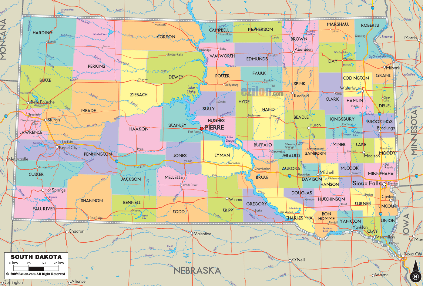
SOUTH DAKOTA MAP
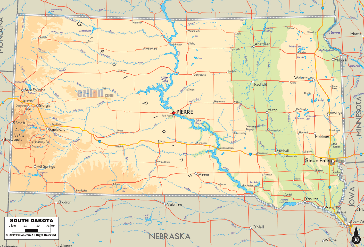
SOUTH DAKOTA PHYSICAL MAP
All South Dakota Cities Maps by Population
Sioux Falls Map -
(153,888)
Rapid City Map -
(67,956)
Aberdeen Map -
(26,091)
Brookings Map -
(22,056)
Watertown Map -
(21,482)
Mitchell Map -
(15,254)
Yankton Map -
(14,454)
Pierre Map -
(13,646)
Huron Map -
(12,592)
Vermillion Map -
(10,571)
Spearfish Map -
(10,494)
Brandon Map -
(8,785)
Rapid Valley Map -
(8,260)
Box Elder Map -
(7,800)
Sturgis Map -
(6,627)
Madison Map -
(6,474)
Belle Fourche Map -
(5,594)
Harrisburg Map -
(4,089)
Tea Map -
(3,806)
Hot Springs Map -
(3,711)
Dell Rapids Map -
(3,633)
Mobridge Map -
(3,465)
Milbank Map -
(3,353)
Pine Ridge Map -
(3,308)
Lead Map -
(3,124)
Canton Map -
(3,057)
Winner Map -
(2,897)
Blackhawk Map -
(2,892)
Dakota Dunes Map -
(2,540)
Hartford Map -
(2,534)
North Sioux City Map -
(2,530)
Colonial Pine Hills Map -
(2,493)
Sisseton Map -
(2,470)
Chamberlain Map -
(2,387)
Flandreau Map -
(2,341)
Redfield Map -
(2,333)
North Spearfish Map -
(2,221)
Lennox Map -
(2,111)
Fort Pierre Map -
(2,078)
Custer Map -
(2,067)
Beresford Map -
(2,005)
Springfield Map -
(1,989)
Elk Point Map -
(1,963)
North Eagle Butte Map -
(1,954)
Webster Map -
(1,886)
Summerset Map -
(1,814)
Volga Map -
(1,768)
Rosebud Map -
(1,587)
Wagner Map -
(1,566)
Parkston Map -
(1,508)
Miller Map -
(1,489)
Groton Map -
(1,458)
Salem Map -
(1,347)
Eagle Butte Map -
(1,318)
Freeman Map -
(1,306)
Gregory Map -
(1,295)
Oglala Map -
(1,290)
Fort Thompson Map -
(1,282)
Clear Lake Map -
(1,273)
Deadwood Map -
(1,270)
Crooks Map -
(1,269)
Britton Map -
(1,241)
Platte Map -
(1,230)
Lemmon Map -
(1,227)
Mission Map -
(1,182)
Garretson Map -
(1,166)
Gettysburg Map -
(1,162)
Clark Map -
(1,139)
Baltic Map -
(1,089)
De Smet Map -
(1,089)
Martin Map -
(1,071)
Tyndall Map -
(1,067)
Porcupine Map -
(1,062)
Parker Map -
(1,022)
Wessington Springs Map -
(956)
Ipswich Map -
(954)
Hill City Map -
(948)
Green Valley Map -
(928)
Whitewood Map -
(927)
Arlington Map -
(915)
Centerville Map -
(882)
Lake Andes Map -
(879)
Worthing Map -
(877)
Eureka Map -
(868)
Howard Map -
(858)
Kyle Map -
(846)
Scotland Map -
(841)
Antelope Map -
(826)
Alcester Map -
(807)
Highmore Map -
(795)
Marion Map -
(784)
Viborg Map -
(782)
Philip Map -
(779)
Edgemont Map -
(774)
Estelline Map -
(768)
Wall Map -
(766)
Valley Springs Map -
(759)
Ashland Heights Map -
(754)
Elkton Map -
(736)
Faulkton Map -
(736)
Wanblee Map -
(725)
St. Francis Map -
(709)
Plankinton Map -
(707)
Kimball Map -
(703)
Armour Map -
(699)
Colton Map -
(687)
Lake Madison Map -
(683)
McLaughlin Map -
(663)
New Underwood Map -
(660)
Johnson Siding Map -
(659)
Onida Map -
(658)
Canistota Map -
(656)
Woonsocket Map -
(655)
Kadoka Map -
(654)
Tripp Map -
(647)
Selby Map -
(642)
Castlewood Map -
(627)
Manderson White Horse Creek Map -
(626)
Alexandria Map -
(615)
Lower Brule Map -
(613)
Menno Map -
(608)
Burke Map -
(604)
Newell Map -
(603)
Lake Preston Map -
(599)
Colman Map -
(594)
Corsica Map -
(592)
Avon Map -
(590)
Humboldt Map -
(589)
Shindler Map -
(584)
White River Map -
(581)
Waubay Map -
(576)
Parmelee Map -
(562)
Jefferson Map -
(547)
Meadow View Addition Map -
(538)
Aurora Map -
(532)
Veblen Map -
(531)
Dupree Map -
(525)
Goodwill Map -
(513)
Bowdle Map -
(502)
Presho Map -
(497)
Lake Poinsett Map -
(493)
Wilmot Map -
(492)
Bridgewater Map -
(492)
Murdo Map -
(488)
White Map -
(485)
Montrose Map -
(472)
Big Stone City Map -
(467)
Lake Norden Map -
(467)
Mount Vernon Map -
(462)
Blucksberg Mountain Map -
(462)
Leola Map -
(457)
Warner Map -
(457)
Bryant Map -
(456)
Oacoma Map -
(451)
Emery Map -
(447)
Timber Lake Map -
(443)
Herreid Map -
(438)
Tabor Map -
(423)
Rosholt Map -
(423)
Faith Map -
(421)
Allen Map -
(420)
Irene Map -
(420)
Hurley Map -
(415)
Gayville Map -
(407)
Hoven Map -
(406)
Marty Map -
(402)
Hermosa Map -
(398)
Wounded Knee Map -
(382)
Hayti Map -
(381)
Wolsey Map -
(376)
Florence Map -
(374)
White Lake Map -
(372)
Anderson Map -
(371)
Blunt Map -
(354)
Bullhead Map -
(348)
Bristol Map -
(341)
Keystone Map -
(337)
Bison Map -
(333)
Ethan Map -
(331)
Buffalo Map -
(330)
Roscoe Map -
(329)
Wakonda Map -
(321)
Little Eagle Map -
(319)
Pine Lakes Addition Map -
(314)
Langford Map -
(313)
Renner Corner Map -
(305)
Colome Map -
(296)
Hudson Map -
(296)
Summit Map -
(288)
Alpena Map -
(286)
Pukwana Map -
(285)
Stickney Map -
(284)
Egan Map -
(278)
White Horse Map -
(276)
Bonesteel Map -
(275)
Okreek Map -
(269)
Spring Creek Map -
(268)
Henry Map -
(267)
Iroquois Map -
(266)
Chancellor Map -
(264)
Willow Lake Map -
(263)
Chester Map -
(261)
New Effington Map -
(256)
Pollock Map -
(241)
Kennebec Map -
(240)
Delmont Map -
(234)
Trent Map -
(232)
Nisland Map -
(232)
Gary Map -
(227)
Hecla Map -
(227)
Soldier Creek Map -
(227)
South Shore Map -
(225)
Piedmont Map -
(222)
Toronto Map -
(212)
Mellette Map -
(210)
Two Strike Map -
(209)
Geddes Map -
(208)
Hosmer Map -
(208)
Tulare Map -
(207)
Bruce Map -
(204)
Pickstown Map -
(201)
Frederick Map -
(199)
St. Lawrence Map -
(198)
Long Hollow Map -
(192)
St. Onge Map -
(191)
Reliance Map -
(191)
Roslyn Map -
(183)
Agency Village Map -
(181)
Doland Map -
(180)
Mission Hill Map -
(177)
Ramona Map -
(174)
Letcher Map -
(173)
McIntosh Map -
(173)
Kranzburg Map -
(172)
Bath Map -
(172)
La Plant Map -
(171)
Wentworth Map -
(171)
Wessington Map -
(170)
Peever Map -
(168)
Volin Map -
(161)
Monroe Map -
(160)
Brant Lake Map -
(159)
Spencer Map -
(154)
Norris Map -
(152)
Frankfort Map -
(149)
Goodwin Map -
(146)
Carthage Map -
(144)
Northville Map -
(143)
Whitehorse Map -
(141)
Conde Map -
(140)
Astoria Map -
(139)
Artesian Map -
(138)
Columbia Map -
(136)
Vale Map -
(136)
Pierpont Map -
(135)
Isabel Map -
(135)
Central City Map -
(134)
Oldham Map -
(133)
Westport Map -
(133)
Midland Map -
(129)
Java Map -
(129)
Lesterville Map -
(127)
Claremont Map -
(127)
Buffalo Gap Map -
(126)
Oelrichs Map -
(126)
Dimock Map -
(125)
Harrold Map -
(124)
Ashton Map -
(122)
Sinai Map -
(120)
Dallas Map -
(120)
Revillo Map -
(119)
Vivian Map -
(119)
Fairfax Map -
(115)
Cavour Map -
(114)
Pringle Map -
(112)
Corona Map -
(109)
Yale Map -
(108)
Batesland Map -
(108)
Stockholm Map -
(108)
Badger Map -
(107)
Brandt Map -
(107)
Glenham Map -
(105)
Herrick Map -
(105)
Canova Map -
(105)
Corn Creek Map -
(105)
Morningside Map -
(105)
Cresbard Map -
(104)
Interior Map -
(94)
Mansfield Map -
(93)
Andover Map -
(91)
Fulton Map -
(91)
Hitchcock Map -
(91)
Hazel Map -
(91)
Richland Map -
(89)
Eden Map -
(89)
Davis Map -
(85)
Wallace Map -
(85)
Fairburn Map -
(85)
Dante Map -
(84)
Draper Map -
(82)
Wasta Map -
(80)
New Witten Map -
(79)
Sherman Map -
(78)
Brentford Map -
(77)
Claire City Map -
(76)
New Holland Map -
(76)
Agar Map -
(76)
Olivet Map -
(74)
Forestburg Map -
(73)
Strandburg Map -
(72)
Bradley Map -
(72)
Stratford Map -
(72)
Mound City Map -
(71)
Twin Brooks Map -
(69)
La Bolt Map -
(68)
Morristown Map -
(67)
Ortley Map -
(65)
Utica Map -
(65)
Bushnell Map -
(65)
Fruitdale Map -
(64)
Orient Map -
(63)
Camp Crook Map -
(63)
Ree Heights Map -
(62)
Wood Map -
(62)
Ravinia Map -
(61)
Fairview Map -
(60)
Lane Map -
(59)
Kidder Map -
(57)
Grenville Map -
(54)
Quinn Map -
(54)
Garden City Map -
(53)
Winfred Map -
(52)
Harrison Map -
(52)
Lake City Map -
(51)
Raymond Map -
(50)
Bath Corner Map -
(49)
Belvidere Map -
(49)
Ward Map -
(48)
Turton Map -
(48)
Lebanon Map -
(47)
Kaylor Map -
(47)
Hetland Map -
(46)
Vienna Map -
(45)
Erwin Map -
(45)
Nunda Map -
(43)
Ferney Map -
(43)
Akaska Map -
(42)
Naples Map -
(41)
Seneca Map -
(38)
Fedora Map -
(37)
Waverly Map -
(37)
Dolton Map -
(37)
Tolstoy Map -
(36)
Okaton Map -
(36)
Running Water Map -
(36)
Green Grass Map -
(35)
Loomis Map -
(34)
Marvin Map -
(34)
Altamont Map -
(34)
Rockham Map -
(33)
Broadland Map -
(31)
Long Lake Map -
(31)
Cow Creek Map -
(30)
Chelsea Map -
(27)
Prairie City Map -
(23)
Vilas Map -
(20)
Crocker Map -
(19)
Bancroft Map -
(19)
Butler Map -
(17)
Albee Map -
(16)
Virgil Map -
(16)
Onaka Map -
(15)
Roswell Map -
(15)
Gann Valley Map -
(14)
Ola Map -
(13)
Aurora Center Map -
(12)
Hamill Map -
(11)
St. Charles Map -
(11)
Milltown Map -
(10)
Farmer Map -
(10)
Cottonwood Map -
(9)
Artas Map -
(9)
Wetonka Map -
(8)
Storla Map -
(6)
Bijou Hills Map -
(6)
Lowry Map -
(6)
Verdon Map -
(5)
Lily Map -
(4)
White Rock Map -
(3)
Hillsview Map -
(3)