With interactive Oklahoma Map, view regional highways maps, road situations, transportation, lodging guide, geographical map, physical maps and more information. On Oklahoma Map, you can view all states, regions, cities, towns, districts, avenues, streets and popular centers' satellite, sketch and terrain maps.
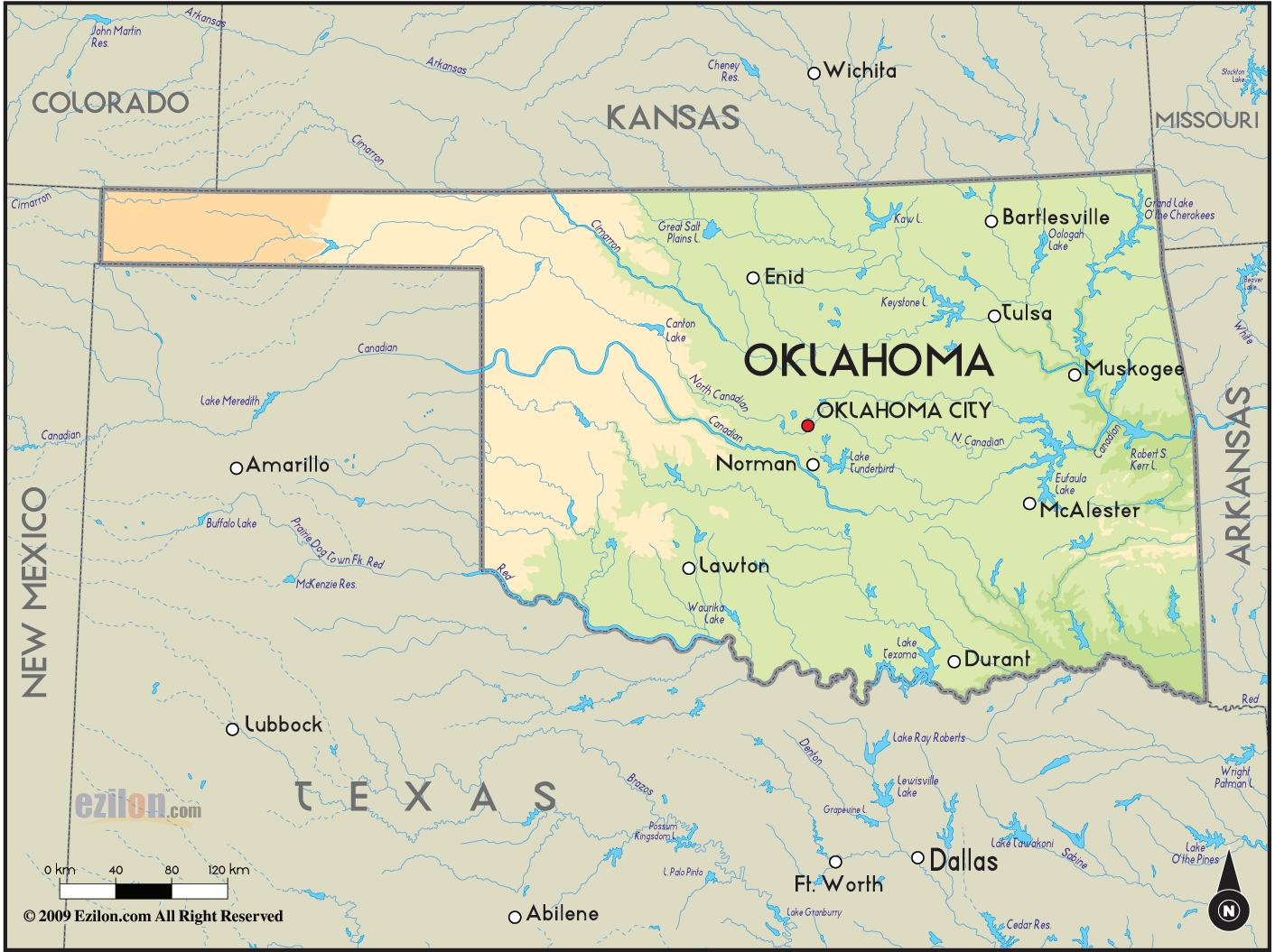
OKLAHOMA MAP
OKLAHOMA CITY MAP

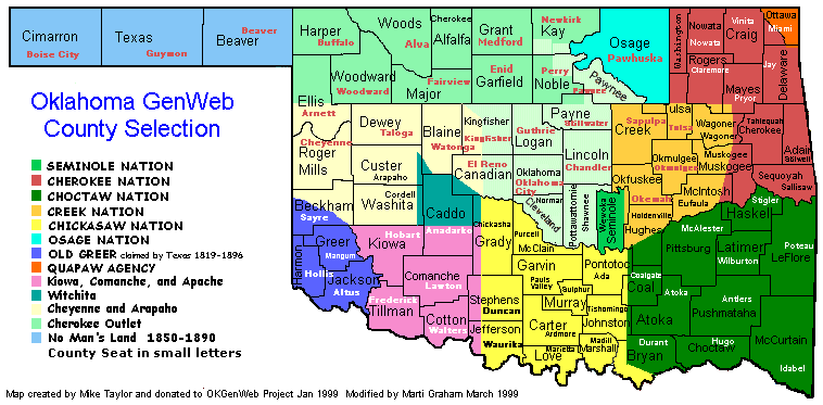
OKLAHOMA COUNTY SELECTION MAP
All Oklahoma Cities Maps by Population
Oklahoma City Map -
(579,999)
Tulsa Map -
(391,906)
Norman Map -
(110,925)
Broken Arrow Map -
(98,850)
Lawton Map -
(96,867)
Edmond Map -
(81,405)
Moore Map -
(55,081)
Midwest City Map -
(54,371)
Enid Map -
(49,379)
Stillwater Map -
(45,688)
Muskogee Map -
(39,223)
Bartlesville Map -
(35,750)
Shawnee Map -
(29,857)
Owasso Map -
(28,915)
Ponca City Map -
(25,387)
Ardmore Map -
(24,283)
Duncan Map -
(23,431)
Yukon Map -
(22,709)
Del City Map -
(21,332)
Bixby Map -
(20,884)
Sapulpa Map -
(20,544)
Altus Map -
(19,813)
Bethany Map -
(19,051)
Sand Springs Map -
(18,906)
Claremore Map -
(18,581)
McAlester Map -
(18,383)
Mustang Map -
(17,395)
Jenks Map -
(16,924)
Ada Map -
(16,810)
El Reno Map -
(16,749)
Chickasha Map -
(16,036)
Durant Map -
(15,856)
Tahlequah Map -
(15,753)
Miami Map -
(13,570)
Okmulgee Map -
(12,321)
Woodward Map -
(12,051)
Elk City Map -
(11,693)
Guymon Map -
(11,442)
Choctaw Map -
(11,146)
Weatherford Map -
(10,833)
Glenpool Map -
(10,808)
Guthrie Map -
(10,191)
Warr Acres Map -
(10,043)
Coweta Map -
(9,943)
Pryor Creek Map -
(9,539)
Clinton Map -
(9,033)
The Village Map -
(8,929)
Sallisaw Map -
(8,880)
Poteau Map -
(8,520)
Wagoner Map -
(8,323)
Cushing Map -
(7,826)
Newcastle Map -
(7,685)
Blanchard Map -
(7,670)
Seminole Map -
(7,488)
Skiatook Map -
(7,397)
Catoosa Map -
(7,151)
Blackwell Map -
(7,092)
Idabel Map -
(7,010)
Anadarko Map -
(6,762)
Grove Map -
(6,623)
Noble Map -
(6,481)
Tecumseh Map -
(6,457)
Pauls Valley Map -
(6,187)
Tuttle Map -
(6,019)
Henryetta Map -
(5,927)
Purcell Map -
(5,884)
Holdenville Map -
(5,771)
Vinita Map -
(5,743)
Piedmont Map -
(5,720)
Collinsville Map -
(5,606)
Hugo Map -
(5,310)
Perry Map -
(5,126)
Watonga Map -
(5,111)
Harrah Map -
(5,095)
Lone Grove Map -
(5,054)
Alva Map -
(4,945)
Sulphur Map -
(4,929)
Marlow Map -
(4,662)
Kingfisher Map -
(4,633)
Sayre Map -
(4,375)
Bristow Map -
(4,222)
Fort Gibson Map -
(4,154)
Slaughterville Map -
(4,137)
Broken Bow Map -
(4,120)
Pocola Map -
(4,056)
McLoud Map -
(4,044)
Verdigris Map -
(3,993)
Stilwell Map -
(3,949)
Frederick Map -
(3,940)
Spencer Map -
(3,912)
Park Hill Map -
(3,909)
Madill Map -
(3,770)
Hobart Map -
(3,756)
Nowata Map -
(3,731)
Nichols Hills Map -
(3,710)
Pawhuska Map -
(3,584)
Hominy Map -
(3,565)
Muldrow Map -
(3,466)
Dewey Map -
(3,432)
Wewoka Map -
(3,430)
Heavener Map -
(3,414)
Checotah Map -
(3,335)
Cleveland Map -
(3,251)
Okemah Map -
(3,223)
Tonkawa Map -
(3,216)
Hinton Map -
(3,196)
Roland Map -
(3,169)
Atoka Map -
(3,107)
Chandler Map -
(3,100)
Mannford Map -
(3,076)
Tishomingo Map -
(3,034)
Mangum Map -
(3,010)
New Cordell Map -
(2,915)
Drumright Map -
(2,907)
Bethel Acres Map -
(2,895)
Wilburton Map -
(2,843)
Lindsay Map -
(2,840)
Perkins Map -
(2,831)
Eufaula Map -
(2,813)
Cache Map -
(2,796)
Healdton Map -
(2,788)
Turley Map -
(2,756)
Longtown Map -
(2,739)
Jones Map -
(2,692)
Stroud Map -
(2,690)
Stigler Map -
(2,685)
Davis Map -
(2,683)
Marietta Map -
(2,626)
Fairview Map -
(2,579)
Walters Map -
(2,551)
Commerce Map -
(2,473)
Antlers Map -
(2,453)
Jay Map -
(2,448)
Nicoma Park Map -
(2,393)
Prague Map -
(2,386)
Newkirk Map -
(2,317)
Texanna Map -
(2,261)
Wynnewood Map -
(2,212)
Pawnee Map -
(2,196)
Oakhurst Map -
(2,185)
Calera Map -
(2,164)
Spiro Map -
(2,164)
Elgin Map -
(2,156)
Lexington Map -
(2,152)
Hennessey Map -
(2,131)
Hartshorne Map -
(2,125)
Chouteau Map -
(2,097)
Granite Map -
(2,065)
Waurika Map -
(2,064)
Hollis Map -
(2,060)
Pink Map -
(2,058)
Burns Flat Map -
(2,057)
Krebs Map -
(2,053)
Haskell Map -
(2,007)
Arkoma Map -
(1,989)
Coalgate Map -
(1,967)
Chelsea Map -
(1,964)
Hooker Map -
(1,918)
Goldsby Map -
(1,801)
Inola Map -
(1,788)
Wilson Map -
(1,724)
Langston Map -
(1,724)
Carnegie Map -
(1,723)
Kiefer Map -
(1,685)
Comanche Map -
(1,663)
Union City Map -
(1,645)
Warner Map -
(1,641)
Westville Map -
(1,639)
Minco Map -
(1,632)
Copeland Map -
(1,629)
Kingston Map -
(1,601)
Stratford Map -
(1,525)
Beaver Map -
(1,515)
Cherokee Map -
(1,498)
Meridian Map -
(1,493)
Morris Map -
(1,479)
Vian Map -
(1,466)
Cleora Map -
(1,463)
Apache Map -
(1,444)
McCord Map -
(1,440)
Locust Grove Map -
(1,423)
Panama Map -
(1,413)
Crescent Map -
(1,411)
Helena Map -
(1,403)
Salina Map -
(1,396)
Snyder Map -
(1,394)
Fairfax Map -
(1,380)
Shattuck Map -
(1,356)
Laverne Map -
(1,344)
Justice Map -
(1,324)
Beggs Map -
(1,321)
Bushyhead Map -
(1,314)
Buffalo Map -
(1,299)
Konawa Map -
(1,298)
Goodwell Map -
(1,293)
Waukomis Map -
(1,286)
Wetumka Map -
(1,282)
Geary Map -
(1,280)
Geronimo Map -
(1,268)
Boise City Map -
(1,266)
Barnsdall Map -
(1,243)
Maysville Map -
(1,232)
Rush Springs Map -
(1,231)
Yale Map -
(1,227)
Kenwood Map -
(1,224)
Luther Map -
(1,221)
Okarche Map -
(1,215)
Bray Map -
(1,209)
Dickson Map -
(1,207)
Sperry Map -
(1,206)
Okeene Map -
(1,204)
Central High Map -
(1,199)
Mooreland Map -
(1,190)
Boley Map -
(1,184)
Thomas Map -
(1,181)
Fletcher Map -
(1,177)
Byng Map -
(1,175)
Mounds Map -
(1,168)
Kellyville Map -
(1,150)
Oologah Map -
(1,146)
Meeker Map -
(1,144)
Colbert Map -
(1,140)
Talihina Map -
(1,114)
Wister Map -
(1,102)
Cyril Map -
(1,059)
Fairland Map -
(1,057)
Oakland Map -
(1,057)
Erick Map -
(1,052)
Quinton Map -
(1,051)
Afton Map -
(1,049)
Maud Map -
(1,048)
Grandfield Map -
(1,038)
Ringling Map -
(1,037)
Shady Point Map -
(1,026)
Oilton Map -
(1,013)
Ninnekah Map -
(1,002)
Temple Map -
(1,002)
Weleetka Map -
(998)
Forest Park Map -
(998)
Caddo Map -
(997)
Medford Map -
(996)
Gore Map -
(977)
Hydro Map -
(969)
Empire City Map -
(955)
Pettit Map -
(954)
Allen Map -
(932)
Waynoka Map -
(927)
Texhoma Map -
(926)
Quapaw Map -
(906)
Sentinel Map -
(901)
Brushy Map -
(900)
Dewar Map -
(888)
Cherry Tree Map -
(883)
Dibble Map -
(878)
Mannsville Map -
(863)
Seiling Map -
(860)
North Enid Map -
(860)
Pond Creek Map -
(856)
Tipton Map -
(847)
West Siloam Springs Map -
(846)
Woodall Map -
(823)
Garber Map -
(822)
Clayton Map -
(821)
Langley Map -
(819)
Blair Map -
(818)
Ryan Map -
(816)
Colcord Map -
(815)
Davenport Map -
(814)
Peggs Map -
(813)
Haileyville Map -
(813)
Cashion Map -
(802)
Howe Map -
(802)
Kansas Map -
(802)
Cheyenne Map -
(801)
Arapaho Map -
(796)
Mountain View Map -
(795)
Sterling Map -
(793)
Adair Map -
(790)
Wellston Map -
(788)
South Coffeyville Map -
(785)
Welling Map -
(771)
Lost City Map -
(770)
Valley Brook Map -
(765)
Wright City Map -
(762)
Tyrone Map -
(762)
Valliant Map -
(754)
Morrison Map -
(733)
Copan Map -
(733)
Flint Creek Map -
(732)
Kiowa Map -
(731)
Porum Map -
(727)
Roff Map -
(725)
Brent Map -
(716)
Boswell Map -
(709)
Springer Map -
(700)
Vici Map -
(699)
Sequoyah Map -
(698)
Elmore City Map -
(697)
Wayne Map -
(688)
Savanna Map -
(686)
Binger Map -
(672)
Carney Map -
(647)
Rock Island Map -
(646)
Fort Cobb Map -
(634)
Tenkiller Map -
(633)
Bokchito Map -
(632)
Limestone Map -
(629)
Earlsboro Map -
(628)
Canton Map -
(625)
Velma Map -
(620)
Okay Map -
(620)
Welch Map -
(619)
Washington Map -
(618)
Webbers Falls Map -
(616)
Lahoma Map -
(611)
Paoli Map -
(610)
Cartwright Map -
(609)
Olustee Map -
(607)
Carlisle Map -
(606)
Glencoe Map -
(601)
Hulbert Map -
(590)
Fairfield Map -
(584)
Hammon Map -
(568)
Porter Map -
(566)
Keys Map -
(565)
Keota Map -
(564)
Dill City Map -
(562)
Bernice Map -
(562)
Remy Map -
(562)
Shady Grove Map -
(556)
Cole Map -
(555)
Alex Map -
(550)
Red Oak Map -
(549)
Forgan Map -
(547)
Canute Map -
(541)
Bell Map -
(535)
Ramona Map -
(535)
Verden Map -
(530)
Ravia Map -
(528)
Eagletown Map -
(528)
Covington Map -
(527)
Arnett Map -
(524)
Fort Towson Map -
(519)
Winchester Map -
(516)
McCurtain Map -
(516)
Bokoshe Map -
(512)
Schulter Map -
(509)
Billings Map -
(509)
Calumet Map -
(507)
Corn Map -
(503)
Cement Map -
(501)
Ringwood Map -
(497)
Zeb Map -
(497)
Akins Map -
(493)
Achille Map -
(492)
Tryon Map -
(491)
Depew Map -
(476)
Stonewall Map -
(470)
Turpin Map -
(467)
Prue Map -
(465)
Redbird Smith Map -
(465)
Dover Map -
(464)
Chattanooga Map -
(461)
Paden Map -
(461)
Drummond Map -
(455)
Eldorado Map -
(446)
Thackerville Map -
(445)
Ketchum Map -
(442)
Gage Map -
(442)
Shidler Map -
(441)
Lone Wolf Map -
(438)
Randlett Map -
(438)
Wapanucka Map -
(438)
Wynona Map -
(437)
Spavinaw Map -
(437)
Leedey Map -
(435)
Crowder Map -
(430)
Ochelata Map -
(424)
East Duke Map -
(424)
Fort Coffee Map -
(424)
Peavine Map -
(423)
Pin Oak Acres Map -
(421)
Rocky Mountain Map -
(420)
Fanshawe Map -
(419)
Amber Map -
(419)
Delaware Map -
(417)
Lamont Map -
(417)
Lane Map -
(414)
Stringtown Map -
(410)
Mountain Park Map -
(409)
New Eucha Map -
(405)
Bowlegs Map -
(405)
Ripley Map -
(403)
Sand Hill Map -
(395)
Dustin Map -
(395)
Grandview Map -
(394)
Belfonte Map -
(394)
Asher Map -
(393)
Tribbey Map -
(391)
Whitefield Map -
(391)
Oktaha Map -
(390)
Medicine Park Map -
(382)
Terral Map -
(382)
Custer City Map -
(375)
Kaw City Map -
(375)
North Miami Map -
(374)
Notchietown Map -
(373)
Greasy Map -
(372)
Long Map -
(370)
Eldon Map -
(368)
Fargo Map -
(364)
Jennings Map -
(363)
Nicut Map -
(360)
Evening Shade Map -
(359)
Lehigh Map -
(356)
Titanic Map -
(356)
Optima Map -
(356)
Carmen Map -
(355)
Wanette Map -
(350)
Katie Map -
(348)
Wauhillau Map -
(345)
Indiahoma Map -
(344)
Wakita Map -
(344)
Foyil Map -
(344)
Bluejacket Map -
(339)
Agra Map -
(339)
Cleo Springs Map -
(338)
Eakly Map -
(338)
Bridge Creek Map -
(336)
Bennington Map -
(334)
Wyandotte Map -
(333)
Silo Map -
(331)
Fort Supply Map -
(330)
Ralston Map -
(330)
Tupelo Map -
(329)
Coyle Map -
(325)
Simms Map -
(325)
Keyes Map -
(324)
Watts Map -
(324)
Sportsmen Acres Map -
(322)
Sawyer Map -
(321)
Avant Map -
(320)
Millerton Map -
(320)
Mill Creek Map -
(319)
Gracemont Map -
(318)
Milburn Map -
(317)
Francis Map -
(315)
Davidson Map -
(315)
Old Green Map -
(315)
Gans Map -
(312)
Cedar Crest Map -
(312)
Tushka Map -
(312)
Disney Map -
(311)
Rattan Map -
(310)
Alderson Map -
(304)
Lebanon Map -
(303)
Briggs Map -
(303)
Cameron Map -
(302)
Taloga Map -
(299)
Westport Map -
(298)
Haworth Map -
(297)
Kinta Map -
(297)
Calvin Map -
(294)
Short Map -
(293)
Lenapah Map -
(293)
Freedom Map -
(289)
Grant Map -
(289)
Cedar Valley Map -
(288)
Lyons Switch Map -
(288)
Oaks Map -
(288)
Butler Map -
(287)
Cromwell Map -
(286)
Rose Map -
(285)
Red Rock Map -
(283)
Talala Map -
(273)
Marshall Map -
(272)
Arpelar Map -
(272)
Big Cabin Map -
(265)
Marble City Map -
(263)
White Oak Map -
(263)
Longdale Map -
(262)
Soper Map -
(261)
Braggs Map -
(259)
Snake Creek Map -
(257)
Carter Map -
(256)
Garvin Map -
(256)
Byars Map -
(255)
Kremlin Map -
(255)
Taft Map -
(250)
Whitesboro Map -
(250)
Goltry Map -
(249)
Roosevelt Map -
(248)
Boynton Map -
(248)
Arcadia Map -
(247)
Johnson Map -
(247)
Breckenridge Map -
(245)
Vera Map -
(241)
Ames Map -
(239)
Stoney Point Map -
(238)
Leach Map -
(237)
Meno Map -
(235)
Proctor Map -
(231)
Fitzhugh Map -
(230)
Dry Creek Map -
(227)
Gotebo Map -
(226)
Mulhall Map -
(225)
Marland Map -
(225)
Box Map -
(224)
Canadian Map -
(220)
Liberty Map -
(220)
Liberty Map -
(220)
Murphy Map -
(219)
Christie Map -
(218)
West Peavine Map -
(218)
Braman Map -
(217)
Dougherty Map -
(215)
Jet Map -
(213)
Hardesty Map -
(212)
Reydon Map -
(210)
Aline Map -
(207)
Pittsburg Map -
(207)
Steely Hollow Map -
(206)
Caney Map -
(205)
Nash Map -
(204)
Elm Grove Map -
(198)
Twin Oaks Map -
(198)
Kenefic Map -
(196)
Dennis Map -
(195)
Blue Map -
(195)
Shady Grove Map -
(194)
Scraper Map -
(191)
Le Flore Map -
(190)
Tiawah Map -
(189)
Dale Map -
(181)
Bessie Map -
(181)
Manitou Map -
(181)
Stuart Map -
(180)
Spaulding Map -
(178)
Camargo Map -
(178)
Sycamore Map -
(177)
Tamaha Map -
(176)
Ballou Map -
(176)
Pump Back Map -
(175)
Pinhook Corner Map -
(171)
Gregory Map -
(171)
Sparks Map -
(169)
Lookeba Map -
(166)
Wainwright Map -
(165)
Hunter Map -
(165)
Bromide Map -
(165)
Cornish Map -
(163)
Rocky Map -
(162)
Martha Map -
(162)
Indianola Map -
(162)
Foster Map -
(161)
Teresita Map -
(159)
Grayson Map -
(159)
St. Louis Map -
(158)
Council Hill Map -
(158)
Gene Autry Map -
(158)
Lamar Map -
(158)
Pocasset Map -
(156)
Osage Map -
(156)
Cowlington Map -
(155)
Drowning Creek Map -
(155)
River Bottom Map -
(154)
Woodlawn Park Map -
(153)
Burlington Map -
(152)
Tatums Map -
(151)
Tuskahoma Map -
(151)
Foss Map -
(151)
Devol Map -
(151)
Cimarron City Map -
(150)
Sasakwa Map -
(150)
Lawrence Creek Map -
(149)
Willow Map -
(149)
Orlando Map -
(148)
Warwick Map -
(148)
Norge Map -
(145)
Hastings Map -
(143)
Albany Map -
(143)
Burbank Map -
(141)
Gould Map -
(141)
Cayuga Map -
(140)
Bee Map -
(140)
Kendrick Map -
(139)
Summit Map -
(139)
Hanna Map -
(138)
Mulberry Map -
(138)
Redbird Map -
(137)
Sams Corner Map -
(137)
Colony Map -
(136)
Isabella Map -
(136)
Faxon Map -
(136)
Chewey Map -
(135)
Phillips Map -
(135)
Sharon Map -
(135)
Fairmont Map -
(134)
Kemp Map -
(133)
Bearden Map -
(133)
Peoria Map -
(132)
New Woodville Map -
(132)
Slick Map -
(131)
Flute Springs Map -
(130)
Bradley Map -
(130)
Deer Creek Map -
(130)
Moffett Map -
(128)
Rentiesville Map -
(128)
Hoffman Map -
(127)
Wann Map -
(125)
Pensacola Map -
(125)
Hallett Map -
(125)
Loco Map -
(122)
Mead Map -
(122)
Zena Map -
(122)
Hillsdale Map -
(121)
Hitchcock Map -
(121)
Cloud Creek Map -
(121)
Ratliff City Map -
(120)
Gerty Map -
(118)
Butler Map -
(117)
Chester Map -
(117)
Bridgeport Map -
(116)
Dodge Map -
(115)
Piney Map -
(115)
Duchess Landing Map -
(114)
Addington Map -
(114)
Smithville Map -
(113)
Salem Map -
(112)
Blackburn Map -
(108)
Dacoma Map -
(107)
Marietta Map -
(106)
Albion Map -
(106)
Castle Map -
(106)
Tullahassee Map -
(106)
Terlton Map -
(106)
Armstrong Map -
(105)
Fair Oaks Map -
(103)
Manchester Map -
(103)
Shamrock Map -
(101)
Dotyville Map -
(101)
Kildare Map -
(100)
Narcissa Map -
(99)
Centrahoma Map -
(97)
Horntown Map -
(97)
Elmer Map -
(96)
Headrick Map -
(94)
Gate Map -
(93)
Greenfield Map -
(93)
Felt Map -
(93)
Iron Post Map -
(92)
Etowah Map -
(92)
Leon Map -
(91)
Mazie Map -
(91)
Maramec Map -
(91)
New Alluwe Map -
(90)
Strang Map -
(89)
Hitchita Map -
(88)
Lake Aluma Map -
(88)
Lucien Map -
(88)
Sweetwater Map -
(87)
Erin Springs Map -
(87)
Carrier Map -
(85)
Paradise Hill Map -
(85)
White Water Map -
(80)
Hendrix Map -
(79)
Loyal Map -
(79)
Valley Park Map -
(77)
Badger Lee Map -
(76)
Wickliffe Map -
(75)
Yeager Map -
(75)
Atwood Map -
(74)
Grand Lake Towne Map -
(74)
Hickory Map -
(71)
Nescatunga Map -
(70)
Rosedale Map -
(68)
Bull Hollow Map -
(67)
Swink Map -
(66)
Smith Village Map -
(66)
Ashland Map -
(66)
Bison Map -
(65)
Oakwood Map -
(65)
Brooksville Map -
(63)
Webb City Map -
(62)
Mutual Map -
(61)
Rocky Ford Map -
(61)
Sour John Map -
(60)
Dwight Mission Map -
(55)
Lima Map -
(53)
Old Eucha Map -
(52)
Nardin Map -
(52)
Skedee Map -
(51)
IXL Map -
(51)
Blackgum Map -
(51)
Hollister Map -
(50)
Dripping Springs Map -
(50)
Gideon Map -
(49)
Indianola Map -
(48)
Clearview Map -
(48)
Strong City Map -
(47)
Deer Lick Map -
(46)
Sugden Map -
(43)
Zion Map -
(41)
May Map -
(39)
Meridian Map -
(38)
Amorita Map -
(37)
Texola Map -
(36)
Byron Map -
(35)
Brush Creek Map -
(35)
Macomb Map -
(32)
Douglas Map -
(32)
Grainola Map -
(31)
Rosston Map -
(31)
Putnam Map -
(29)
Fallis Map -
(27)
Friendship Map -
(24)
Capron Map -
(23)
Picher Map -
(20)
Foraker Map -
(19)
Stidham Map -
(18)
Oak Grove Map -
(18)
Kenton Map -
(17)
Cooperton Map -
(16)
Tagg Flats Map -
(13)
Loveland Map -
(13)
Jefferson Map -
(12)
Renfrow Map -
(12)
Knowles Map -
(11)
Lambert Map -
(6)
Hoot Owl Map -
(4)
Cardin Map -
(3)
Shady Grove Map -
(2)
Lotsee Map -
(2)