With interactive New Mexico Map, view regional highways maps, road situations, transportation, lodging guide, geographical map, physical maps and more information. On New Mexico Map, you can view all states, regions, cities, towns, districts, avenues, streets and popular centers' satellite, sketch and terrain maps.
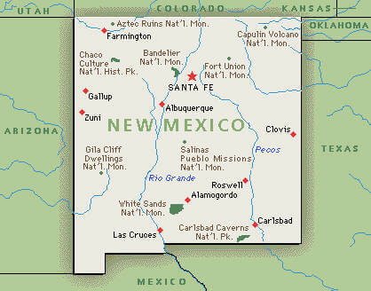
NEW MEXICO MAP
NEW MEXICO CITY MAP
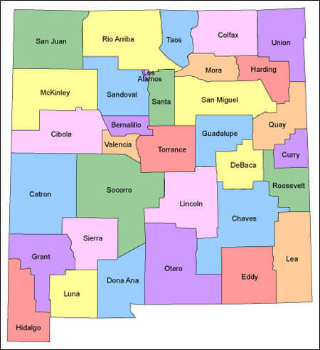
NEW MEXICO COUNTY MAP
Whispers of the Southwest: An Albuquerque Adventure
Please subscribe on "World Guide" channnel on Youtube at youtube.com/c/WorldGuide
The Earth, North America and Countries View from Space - Day Time and in the Night
All New Mexico Cities Maps by Population
Albuquerque Map -
(545,852)
Las Cruces Map -
(97,618)
Rio Rancho Map -
(87,521)
Santa Fe Map -
(67,947)
Roswell Map -
(48,366)
Farmington Map -
(45,877)
South Valley Map -
(40,976)
Clovis Map -
(37,775)
Hobbs Map -
(34,122)
Alamogordo Map -
(30,403)
Carlsbad Map -
(26,138)
Gallup Map -
(21,678)
Deming Map -
(14,855)
Los Lunas Map -
(14,835)
Chaparral Map -
(14,631)
Sunland Park Map -
(14,106)
Las Vegas Map -
(13,753)
Portales Map -
(12,280)
Los Alamos Map -
(12,019)
North Valley Map -
(11,333)
Artesia Map -
(11,301)
Lovington Map -
(11,009)
Silver City Map -
(10,315)
Espanola Map -
(10,224)
Anthony Map -
(9,360)
Grants Map -
(9,182)
Socorro Map -
(9,051)
Corrales Map -
(8,329)
Bernalillo Map -
(8,320)
Shiprock Map -
(8,295)
Bloomfield Map -
(8,112)
Ruidoso Map -
(8,029)
Kirtland Map -
(7,875)
Belen Map -
(7,269)
Raton Map -
(6,885)
Aztec Map -
(6,763)
Truth or Consequences Map -
(6,475)
Zuni Pueblo Map -
(6,302)
Eldorado at Santa Fe Map -
(6,130)
Los Ranchos de Albuquerque Map -
(6,024)
Lee Acres Map -
(5,858)
White Rock Map -
(5,725)
Taos Map -
(5,716)
Los Chaves Map -
(5,446)
North Hobbs Map -
(5,391)
Tucumcari Map -
(5,363)
Placitas Map -
(4,977)
Rio Communities Map -
(4,723)
Meadow Lake Map -
(4,708)
El Cerro Mission Map -
(4,657)
Santa Teresa Map -
(4,258)
Paradise Hills Map -
(4,256)
University Park Map -
(4,192)
Bosque Farms Map -
(3,904)
La Cienega Map -
(3,819)
Edgewood Map -
(3,735)
Peralta Map -
(3,660)
Milan Map -
(3,245)
Vado Map -
(3,194)
Sandia Heights Map -
(3,193)
Chimayo Map -
(3,177)
Holloman AFB Map -
(3,054)
Clayton Map -
(2,980)
El Cerro Map -
(2,953)
Eunice Map -
(2,922)
Santa Rosa Map -
(2,848)
Tularosa Map -
(2,842)
Ruidoso Downs Map -
(2,815)
Agua Fria Map -
(2,800)
Lordsburg Map -
(2,797)
West Hammond Map -
(2,790)
Dulce Map -
(2,743)
Ranchos de Taos Map -
(2,518)
Jarales Map -
(2,475)
Santo Domingo Pueblo Map -
(2,456)
San Felipe Pueblo Map -
(2,404)
Bayard Map -
(2,328)
Crownpoint Map -
(2,278)
Cannon AFB Map -
(2,245)
Mesilla Map -
(2,196)
Valencia Map -
(2,192)
Flora Vista Map -
(2,191)
San Ysidro Map -
(2,090)
Jal Map -
(2,047)
Moriarty Map -
(1,910)
Pojoaque Map -
(1,907)
Tome Map -
(1,867)
Thoreau Map -
(1,865)
Nambe Map -
(1,818)
Jemez Pueblo Map -
(1,788)
Arroyo Seco Map -
(1,785)
La Mesilla Map -
(1,772)
Questa Map -
(1,770)
Radium Springs Map -
(1,699)
La Luz Map -
(1,697)
Santa Clara Map -
(1,686)
Waterflow Map -
(1,670)
Columbus Map -
(1,664)
Upper Fruitland Map -
(1,662)
Estancia Map -
(1,655)
White Sands Map -
(1,651)
Hatch Map -
(1,648)
Navajo Map -
(1,645)
Boles Acres Map -
(1,638)
Las Maravillas Map -
(1,628)
Monterey Park Map -
(1,567)
Arenas Valley Map -
(1,522)
Capitan Map -
(1,489)
McIntosh Map -
(1,484)
Berino Map -
(1,441)
El Valle de Arroyo Seco Map -
(1,440)
Elephant Butte Map -
(1,431)
Loving Map -
(1,413)
Pecos Map -
(1,392)
Mescalero Map -
(1,338)
Black Rock Map -
(1,323)
Keeler Farm Map -
(1,305)
Hurley Map -
(1,297)
Dexter Map -
(1,266)
Spencerville Map -
(1,258)
Hagerman Map -
(1,257)
La Huerta Map -
(1,246)
Laguna Map -
(1,241)
Carnuel Map -
(1,232)
Skyline Ganipa Map -
(1,224)
Angel Fire Map -
(1,216)
Doña Ana Map -
(1,211)
Sandia Knolls Map -
(1,208)
El Rancho Map -
(1,199)
Ponderosa Pine Map -
(1,195)
La Puebla Map -
(1,186)
San Miguel Map -
(1,153)
Ohkay Owingeh Map -
(1,143)
Taos Pueblo Map -
(1,135)
Texico Map -
(1,130)
Church Rock Map -
(1,128)
Mesquite Map -
(1,112)
La Union Map -
(1,106)
Alamo Map -
(1,085)
Atoka Map -
(1,077)
Sausal Map -
(1,056)
Twin Lakes Map -
(1,052)
Springer Map -
(1,047)
Logan Map -
(1,042)
Fort Sumner Map -
(1,031)
Chama Map -
(1,022)
Cimarron Map -
(1,021)
Santa Clara Pueblo Map -
(1,018)
Carrizozo Map -
(996)
San Antonito Map -
(985)
Midway Map -
(971)
Cedar Crest Map -
(958)
La Villita Map -
(957)
Hernandez Map -
(946)
Salem Map -
(942)
Magdalena Map -
(938)
San Rafael Map -
(933)
Mountainair Map -
(928)
Dixon Map -
(926)
Tesuque Map -
(925)
Chamberino Map -
(919)
Los Luceros Map -
(906)
Indian Hills Map -
(892)
Chamita Map -
(870)
Cedar Hill Map -
(847)
High Rolls Map -
(834)
Fairacres Map -
(824)
Adelino Map -
(823)
Algodones Map -
(814)
Tohatchi Map -
(808)
El Rito Map -
(808)
San Pablo Map -
(806)
Mesita Map -
(804)
Sedillo Map -
(802)
Tatum Map -
(798)
Pueblitos Map -
(794)
Talpa Map -
(778)
Paraje Map -
(777)
Ojo Amarillo Map -
(766)
East Pecos Map -
(757)
Cedar Grove Map -
(747)
Zia Pueblo Map -
(737)
Cuba Map -
(731)
La Mesa Map -
(728)
Napi Headquarters Map -
(727)
La Hacienda Map -
(725)
Peña Blanca Map -
(709)
Madrone Map -
(707)
El Duende Map -
(707)
San Jose Map -
(695)
Nenahnezad Map -
(688)
Cloudcroft Map -
(674)
Mimbres Map -
(667)
Mora Map -
(656)
Chili Map -
(654)
Melrose Map -
(651)
Tyrone Map -
(637)
Bluewater Village Map -
(628)
Highland Meadows Map -
(624)
La Plata Map -
(612)
Santa Ana Pueblo Map -
(610)
Livingston Wheeler Map -
(609)
Yah ta hey Map -
(590)
Peñasco Map -
(589)
Pajarito Mesa Map -
(579)
Placitas Map -
(576)
Cochiti Lake Map -
(569)
Rock Springs Map -
(567)
Truchas Map -
(560)
Tijeras Map -
(541)
Cochiti Map -
(528)
San Ildefonso Pueblo Map -
(524)
Happy Valley Map -
(519)
Velarde Map -
(502)
Isleta Village Proper Map -
(491)
Cuyamungue Map -
(479)
Red River Map -
(477)
Arroyo Hondo Map -
(474)
Cuartelez Map -
(469)
Ventura Map -
(468)
Nakaibito Map -
(466)
Seama Map -
(465)
Williamsburg Map -
(449)
Vaughn Map -
(446)
Lake Arthur Map -
(436)
Cañada de los Alamos Map -
(434)
Glorieta Map -
(430)
Cedro Map -
(430)
Paguate Map -
(421)
Sunshine Map -
(420)
Acomita Lake Map -
(416)
Ribera Map -
(416)
Rowe Map -
(415)
North Light Plant Map -
(414)
Cordova Map -
(414)
Jacona Map -
(412)
Rosedale Map -
(394)
Rio Lucio Map -
(389)
Cotton City Map -
(388)
Rodey Map -
(388)
Blanco Map -
(388)
Ponderosa Map -
(387)
Tierra Amarilla Map -
(382)
Peak Place Map -
(377)
Nadine Map -
(376)
Sanostee Map -
(371)
Ramah Map -
(370)
Pueblo of Sandia Village Map -
(369)
Santa Cruz Map -
(368)
Morningside Map -
(367)
Chupadero Map -
(362)
Sombrillo Map -
(351)
Timberon Map -
(348)
Newcomb Map -
(339)
Jaconita Map -
(332)
Lemitar Map -
(330)
Cañon Map -
(327)
Torreon Map -
(326)
Organ Map -
(323)
Los Cerrillos Map -
(321)
Beclabito Map -
(317)
Wagon Mound Map -
(314)
Gila Map -
(314)
Crystal Map -
(311)
Chamisal Map -
(310)
North Acomita Village Map -
(303)
Naschitti Map -
(301)
North Hurley Map -
(300)
Tse Bonito Map -
(299)
Tecolote Map -
(298)
Cliff Map -
(293)
Eagle Nest Map -
(290)
Reserve Map -
(289)
Cubero Map -
(289)
Gallina Map -
(286)
Nageezi Map -
(286)
Alcalde Map -
(285)
Navajo Dam Map -
(281)
San Cristobal Map -
(273)
Casa Colorada Map -
(272)
Rincon Map -
(271)
Vadito Map -
(270)
Polvadera Map -
(269)
Canjilon Map -
(256)
Maxwell Map -
(254)
Galisteo Map -
(253)
Willard Map -
(253)
Jemez Springs Map -
(250)
Sheep Springs Map -
(245)
Lyden Map -
(245)
Sandia Park Map -
(237)
Torreon Map -
(237)
Animas Map -
(237)
Roy Map -
(234)
Tesuque Pueblo Map -
(233)
Arrey Map -
(232)
Tecolotito Map -
(232)
Veguita Map -
(232)
Abiquiu Map -
(231)
Villanueva Map -
(229)
Quemado Map -
(228)
Cuyamungue Grant Map -
(226)
Lamy Map -
(218)
San Jon Map -
(216)
Edith Endave Map -
(211)
Encinal Map -
(210)
Soham Map -
(210)
Glen Acres Map -
(208)
La Jara Map -
(207)
Monument Map -
(206)
Bluewater Acres Map -
(206)
Costilla Map -
(205)
Madrid Map -
(204)
Buckhorn Map -
(200)
Brimhall Nizhoni Map -
(199)
Pinos Altos Map -
(198)
Elida Map -
(197)
Twin Forks Map -
(196)
San Ysidro Map -
(193)
Pueblo Pintado Map -
(192)
Anton Chico Map -
(188)
Young Place Map -
(187)
Pie Town Map -
(186)
Conchas Dam Map -
(186)
San Pedro Map -
(184)
White Signal Map -
(181)
Seboyeta Map -
(179)
Las Palomas Map -
(173)
Corona Map -
(172)
La Cueva Map -
(168)
Hanover Map -
(167)
San Antonio Map -
(165)
San Mateo Map -
(161)
North San Ysidro Map -
(159)
Luna Map -
(158)
La Madera Map -
(154)
Virden Map -
(152)
Las Nutrias Map -
(149)
Oasis Map -
(149)
Malaga Map -
(147)
Des Moines Map -
(143)
Lake Sumner Map -
(143)
Glenwood Map -
(143)
Rio en Medio Map -
(143)
Rancho Grande Map -
(142)
Puerto de Luna Map -
(141)
Bibo Map -
(140)
San Fidel Map -
(138)
Garfield Map -
(137)
San Jose Map -
(137)
Chilili Map -
(137)
Manzano Springs Map -
(137)
Watrous Map -
(135)
Dora Map -
(133)
Floyd Map -
(133)
Tajique Map -
(130)
Sena Map -
(129)
Coyote Map -
(128)
Loco Hills Map -
(126)
Los Ojos Map -
(125)
Pueblo Map -
(125)
Hillsboro Map -
(124)
Mountain View Map -
(122)
Pulpotio Bareas Map -
(120)
Bent Map -
(119)
Escudilla Bonita Map -
(119)
Cañones Map -
(118)
Canova Map -
(118)
Llano del Medio Map -
(118)
Caballo Map -
(112)
Hot Springs Landing Map -
(110)
Chical Map -
(107)
Ensenada Map -
(107)
Grady Map -
(107)
Luis Lopez Map -
(107)
Pleasanton Map -
(106)
Regina Map -
(105)
South Acomita Village Map -
(105)
Hope Map -
(105)
Causey Map -
(104)
Alamillo Map -
(102)
Rodeo Map -
(101)
Chamizal Map -
(101)
San Lorenzo Map -
(97)
Nogal Map -
(96)
Nara Visa Map -
(95)
Aragon Map -
(94)
San Antonito Map -
(94)
Mosquero Map -
(93)
Pueblito Map -
(91)
Pinehill Map -
(88)
La Joya Map -
(82)
Encino Map -
(82)
Middle Frisco Map -
(77)
Mayhill Map -
(75)
Pecan Park Map -
(75)
Playas Map -
(74)
Lumberton Map -
(73)
Cruzville Map -
(72)
Cundiyo Map -
(72)
Ute Park Map -
(71)
Taos Ski Valley Map -
(69)
House Map -
(68)
Picuris Pueblo Map -
(68)
Apache Creek Map -
(67)
Capulin Map -
(66)
Lake Valley Map -
(64)
Weed Map -
(63)
Winston Map -
(61)
San Luis Map -
(59)
Sacramento Map -
(58)
Youngsville Map -
(56)
Folsom Map -
(56)
Abeytas Map -
(56)
Datil Map -
(54)
Anzac Village Map -
(54)
Lake Roberts Map -
(53)
Orogrande Map -
(52)
Hachita Map -
(49)
McCartys Village Map -
(48)
Escondida Map -
(47)
Homestead Map -
(47)
San Acacia Map -
(44)
Brazos Map -
(44)
Windmill Map -
(43)
Fence Lake Map -
(42)
Cobre Map -
(39)
Grenville Map -
(38)
Golden Map -
(37)
Moquino Map -
(37)
Duran Map -
(35)
Faywood Map -
(33)
Kingston Map -
(32)
Lake Roberts Heights Map -
(32)
Lower Frisco Map -
(31)
City of the Sun Map -
(31)
Manzano Map -
(29)
Rivers Map -
(28)
Pinon Map -
(25)
Pastura Map -
(23)
Trout Valley Map -
(16)
Newkirk Map -
(7)
Whites City Map -
(7)