With interactive Nebraska Map, view regional highways maps, road situations, transportation, lodging guide, geographical map, physical maps and more information. On Nebraska Map, you can view all states, regions, cities, towns, districts, avenues, streets and popular centers' satellite, sketch and terrain maps.
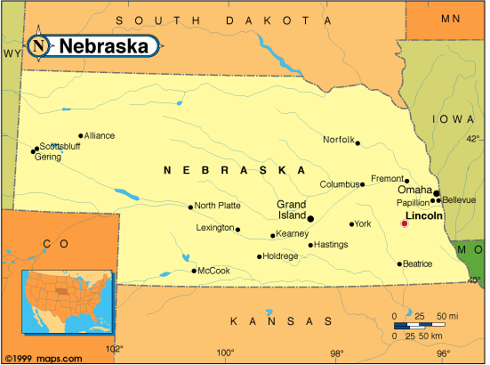
NEBRASKA MAP
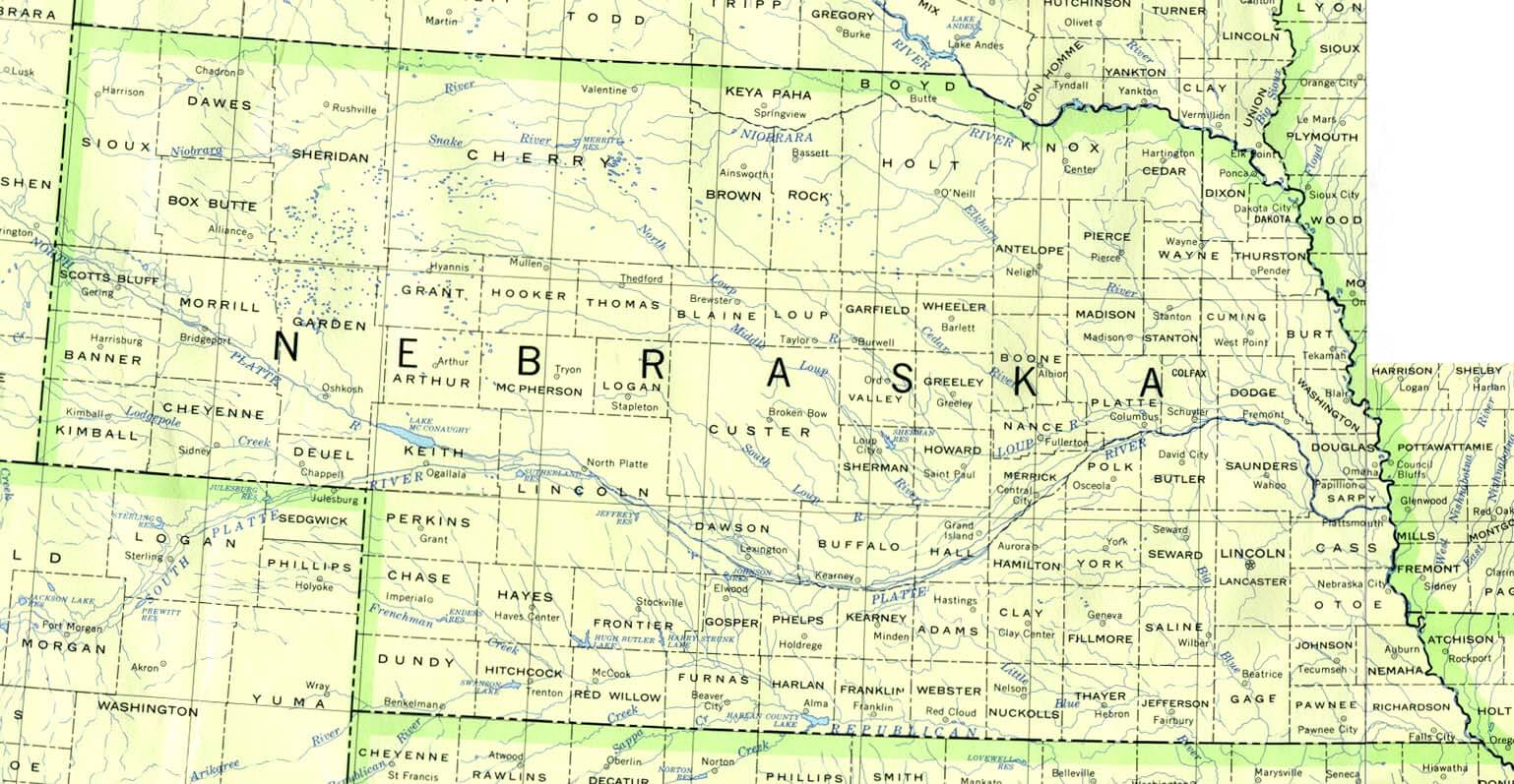
NEBRASKA COUNTIES MAP
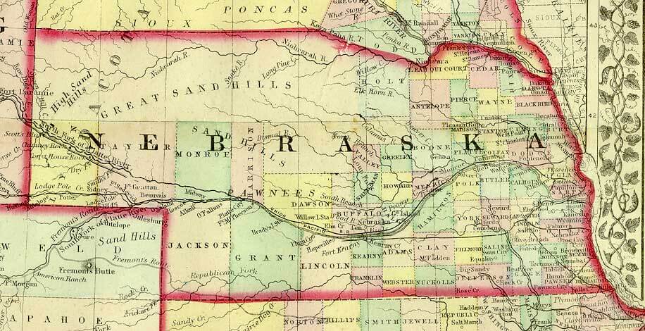
NEBRASKA HISTORICAL MAP
All Nebraska Cities Maps by Population
Omaha Map -
(408,958)
Lincoln Map -
(258,379)
Bellevue Map -
(50,137)
Grand Island Map -
(48,520)
Kearney Map -
(30,787)
Fremont Map -
(26,397)
Hastings Map -
(24,907)
North Platte Map -
(24,733)
Norfolk Map -
(24,210)
Columbus Map -
(22,111)
Papillion Map -
(18,894)
La Vista Map -
(15,758)
Scottsbluff Map -
(15,039)
South Sioux City Map -
(13,353)
Beatrice Map -
(12,459)
Chalco Map -
(10,994)
Lexington Map -
(10,230)
Gering Map -
(8,500)
Alliance Map -
(8,491)
Blair Map -
(7,990)
York Map -
(7,766)
McCook Map -
(7,698)
Nebraska City Map -
(7,289)
Seward Map -
(6,964)
Crete Map -
(6,960)
Sidney Map -
(6,757)
Plattsmouth Map -
(6,502)
Schuyler Map -
(6,211)
Ralston Map -
(5,943)
Chadron Map -
(5,851)
Wayne Map -
(5,660)
Holdrege Map -
(5,495)
Ogallala Map -
(4,737)
Offutt AFB Map -
(4,644)
Wahoo Map -
(4,508)
Aurora Map -
(4,479)
Gretna Map -
(4,441)
Falls City Map -
(4,325)
Cozad Map -
(3,977)
Fairbury Map -
(3,942)
O'Neill Map -
(3,705)
Gothenburg Map -
(3,574)
Broken Bow Map -
(3,559)
Auburn Map -
(3,460)
West Point Map -
(3,364)
Waverly Map -
(3,277)
Central City Map -
(2,934)
Minden Map -
(2,923)
David City Map -
(2,906)
Valentine Map -
(2,737)
Kimball Map -
(2,496)
Ashland Map -
(2,453)
Madison Map -
(2,438)
St. Paul Map -
(2,290)
Geneva Map -
(2,217)
Ord Map -
(2,112)
Milford Map -
(2,090)
Imperial Map -
(2,071)
Superior Map -
(1,957)
Syracuse Map -
(1,942)
Dakota City Map -
(1,919)
Valley Map -
(1,875)
Woodland Park Map -
(1,866)
Wilber Map -
(1,855)
Gibbon Map -
(1,833)
Pierce Map -
(1,767)
Tekamah Map -
(1,736)
Ainsworth Map -
(1,728)
Mitchell Map -
(1,702)
Tecumseh Map -
(1,677)
Hickman Map -
(1,657)
Albion Map -
(1,650)
Gordon Map -
(1,612)
Neligh Map -
(1,599)
Hebron Map -
(1,579)
Stanton Map -
(1,577)
Hartington Map -
(1,554)
Bridgeport Map -
(1,545)
Springfield Map -
(1,529)
Sutton Map -
(1,502)
Bennington Map -
(1,458)
Wymore Map -
(1,457)
Wakefield Map -
(1,451)
Ravenna Map -
(1,360)
Wood River Map -
(1,325)
Fullerton Map -
(1,307)
Sutherland Map -
(1,286)
Plainview Map -
(1,246)
Atkinson Map -
(1,245)
Oakland Map -
(1,244)
Arlington Map -
(1,243)
Burwell Map -
(1,210)
Bayard Map -
(1,209)
Battle Creek Map -
(1,207)
Terrytown Map -
(1,198)
North Bend Map -
(1,177)
Yutan Map -
(1,174)
Stromsburg Map -
(1,171)
Wisner Map -
(1,170)
Grant Map -
(1,165)
Creighton Map -
(1,154)
Alma Map -
(1,133)
Louisville Map -
(1,106)
Cambridge Map -
(1,063)
Shelton Map -
(1,059)
Weeping Water Map -
(1,050)
Loup City Map -
(1,029)
Bloomfield Map -
(1,028)
Friend Map -
(1,027)
Arapahoe Map -
(1,026)
Eagle Map -
(1,024)
Macy Map -
(1,023)
Red Cloud Map -
(1,020)
Harvard Map -
(1,013)
Genoa Map -
(1,003)
Pender Map -
(1,002)
Franklin Map -
(1,000)
Crawford Map -
(997)
Henderson Map -
(991)
Laurel Map -
(964)
Ponca Map -
(961)
Benkelman Map -
(953)
Tilden Map -
(953)
Randolph Map -
(944)
Curtis Map -
(939)
Blue Hill Map -
(936)
Chappell Map -
(929)
Morrill Map -
(921)
Fort Calhoun Map -
(908)
Elm Creek Map -
(901)
Rushville Map -
(890)
Ceresco Map -
(889)
Oshkosh Map -
(884)
Kenesaw Map -
(880)
Osceola Map -
(880)
Pawnee City Map -
(878)
Humboldt Map -
(877)
Peru Map -
(865)
Utica Map -
(861)
Scribner Map -
(857)
Lyons Map -
(851)
Waterloo Map -
(848)
Emerson Map -
(840)
Hooper Map -
(830)
Doniphan Map -
(829)
Minatare Map -
(816)
Hemingford Map -
(803)
Cairo Map -
(785)
Osmond Map -
(783)
Walthill Map -
(780)
Oxford Map -
(779)
Winnebago Map -
(774)
Humphrey Map -
(760)
Clay Center Map -
(760)
Juniata Map -
(755)
Bertrand Map -
(750)
Deshler Map -
(747)
Boys Town Map -
(745)
Axtell Map -
(726)
Crofton Map -
(726)
Newman Grove Map -
(721)
Bennet Map -
(719)
Shelby Map -
(714)
Elwood Map -
(707)
St. Edward Map -
(705)
Beemer Map -
(678)
Hershey Map -
(665)
Elgin Map -
(661)
Clarkson Map -
(658)
Alda Map -
(642)
Elmwood Map -
(634)
Wausa Map -
(634)
Bassett Map -
(619)
Dodge Map -
(612)
Cedar Bluffs Map -
(610)
Beaver City Map -
(609)
Arnold Map -
(597)
Culbertson Map -
(595)
Overton Map -
(594)
Exeter Map -
(591)
Firth Map -
(590)
Stuart Map -
(590)
Dorchester Map -
(586)
Indianola Map -
(584)
Wauneta Map -
(577)
Verdigre Map -
(575)
Adams Map -
(573)
Valparaiso Map -
(570)
Hay Springs Map -
(570)
Mead Map -
(569)
Greenwood Map -
(568)
Howells Map -
(561)
Trenton Map -
(560)
Fairmont Map -
(560)
Homer Map -
(549)
Palmyra Map -
(545)
Callaway Map -
(539)
Sargent Map -
(525)
Paxton Map -
(523)
De Witt Map -
(513)
Mullen Map -
(509)
Edgar Map -
(498)
Bancroft Map -
(495)
Nelson Map -
(488)
Spalding Map -
(487)
Cortland Map -
(482)
Decatur Map -
(481)
Sterling Map -
(476)
Coleridge Map -
(473)
Palmer Map -
(472)
Glenwood Map -
(466)
Greeley Center Map -
(466)
Murray Map -
(463)
Spencer Map -
(455)
Ansley Map -
(441)
Bellwood Map -
(435)
Brady Map -
(428)
Winside Map -
(427)
Hampton Map -
(423)
Clearwater Map -
(419)
McCool Junction Map -
(409)
Plymouth Map -
(409)
Leigh Map -
(405)
Beaver Crossing Map -
(403)
Eustis Map -
(401)
Big Springs Map -
(400)
Cedar Creek Map -
(390)
Ewing Map -
(387)
Fairfield Map -
(387)
Orleans Map -
(386)
Cedar Rapids Map -
(382)
Malcolm Map -
(382)
Loomis Map -
(382)
Orchard Map -
(379)
Hildreth Map -
(378)
Allen Map -
(377)
Rising City Map -
(374)
Niobrara Map -
(370)
Nickerson Map -
(369)
Clarks Map -
(369)
Wallace Map -
(366)
Merna Map -
(363)
Silver Creek Map -
(362)
Kennard Map -
(361)
Wilcox Map -
(358)
Giltner Map -
(352)
Pilger Map -
(352)
Palisade Map -
(351)
Duncan Map -
(351)
Campbell Map -
(347)
Santee Map -
(346)
Stratton Map -
(343)
Shickley Map -
(341)
Pleasanton Map -
(341)
Lyman Map -
(341)
Potter Map -
(337)
Platte Center Map -
(336)
Petersburg Map -
(333)
Blue Springs Map -
(331)
Brainard Map -
(330)
Johnson Map -
(328)
Butte Map -
(326)
Brule Map -
(326)
Newcastle Map -
(325)
Inglewood Map -
(325)
Weston Map -
(324)
Polk Map -
(322)
Oakdale Map -
(322)
Cook Map -
(321)
Lodgepole Map -
(318)
Scotia Map -
(318)
Lakeview Map -
(317)
Dalton Map -
(315)
Maxwell Map -
(312)
Unadilla Map -
(311)
Arcadia Map -
(311)
Glenvil Map -
(310)
Odell Map -
(307)
Walton Map -
(306)
Long Pine Map -
(305)
Stapleton Map -
(305)
Lawrence Map -
(304)
Dannebrog Map -
(303)
Prague Map -
(303)
Meadow Grove Map -
(301)
Snyder Map -
(300)
North Loup Map -
(297)
Davenport Map -
(294)
Hadar Map -
(293)
Yankee Hill Map -
(292)
Phillips Map -
(287)
Chapman Map -
(287)
Hoskins Map -
(285)
Milligan Map -
(285)
Monroe Map -
(284)
Bartley Map -
(283)
Wolbach Map -
(283)
King Lake Map -
(280)
Bruning Map -
(279)
Bradshaw Map -
(273)
Table Rock Map -
(269)
Herman Map -
(268)
Chambers Map -
(268)
St. Libory Map -
(264)
Litchfield Map -
(262)
Maywood Map -
(261)
Diller Map -
(260)
Panama Map -
(256)
Lindsay Map -
(255)
Dix Map -
(255)
Harrison Map -
(251)
Amherst Map -
(248)
Lynch Map -
(245)
Staplehurst Map -
(242)
Springview Map -
(242)
Avoca Map -
(242)
Bladen Map -
(237)
Murdock Map -
(236)
Waco Map -
(236)
Hubbard Map -
(236)
Sumner Map -
(236)
Roseland Map -
(235)
Western Map -
(235)
Benedict Map -
(234)
Talmage Map -
(233)
Union Map -
(233)
Chester Map -
(232)
Clatonia Map -
(231)
Madrid Map -
(231)
Uehling Map -
(230)
Carroll Map -
(229)
Marquette Map -
(229)
Guide Rock Map -
(225)
Lewellen Map -
(224)
Jackson Map -
(223)
Gresham Map -
(223)
Roca Map -
(220)
Garland Map -
(216)
Belmar Map -
(216)
Woodland Hills Map -
(215)
Elba Map -
(215)
Holstein Map -
(214)
Hayes Center Map -
(214)
Gurley Map -
(214)
Hallam Map -
(213)
Holbrook Map -
(207)
Pleasant Dale Map -
(205)
Trumbull Map -
(205)
Dwight Map -
(204)
Nehawka Map -
(204)
Creston Map -
(203)
Craig Map -
(199)
Pickrell Map -
(199)
Funk Map -
(194)
Ashton Map -
(194)
Bee Map -
(191)
Taylor Map -
(190)
Denton Map -
(190)
Howard City Map -
(189)
Thedford Map -
(188)
Dunbar Map -
(187)
Stamford Map -
(183)
Riverdale Map -
(182)
Hyannis Map -
(182)
Manley Map -
(178)
Alexandria Map -
(177)
Douglas Map -
(173)
Verdon Map -
(172)
Rulo Map -
(172)
Mason City Map -
(171)
Farnam Map -
(171)
Ulysses Map -
(171)
Otoe Map -
(171)
Raymond Map -
(167)
Daykin Map -
(166)
Concord Map -
(166)
Wynot Map -
(166)
Page Map -
(166)
Venango Map -
(164)
Rosalie Map -
(160)
Hardy Map -
(159)
Haigler Map -
(158)
Tryon Map -
(157)
Goehner Map -
(154)
Cody Map -
(154)
Davey Map -
(154)
Overland Map -
(153)
Stella Map -
(152)
Oconto Map -
(151)
Washington Map -
(150)
Shubert Map -
(150)
Republican City Map -
(150)
Nemaha Map -
(149)
Ithaca Map -
(148)
Du Bois Map -
(147)
Dawson Map -
(146)
Anselmo Map -
(145)
Hordville Map -
(144)
Upland Map -
(143)
Sprague Map -
(142)
Fordyce Map -
(139)
Brunswick Map -
(138)
Cordova Map -
(137)
Miller Map -
(136)
Morse Bluff Map -
(135)
Edison Map -
(133)
Filley Map -
(132)
Brownville Map -
(132)
Alvo Map -
(132)
Thurston Map -
(132)
Endicott Map -
(132)
Atlanta Map -
(131)
Odessa Map -
(130)
Inman Map -
(129)
Merriman Map -
(128)
Broadwater Map -
(128)
Octavia Map -
(127)
Grafton Map -
(126)
Belgrade Map -
(126)
Bushnell Map -
(124)
Ruskin Map -
(123)
Farwell Map -
(122)
Malmo Map -
(120)
Jansen Map -
(118)
Arthur Map -
(117)
Bartlett Map -
(117)
Inavale Map -
(117)
Bow Valley Map -
(116)
Barneston Map -
(116)
Ohiowa Map -
(115)
Belden Map -
(115)
Memphis Map -
(114)
La Platte Map -
(114)
Brock Map -
(112)
Aten Map -
(112)
Melbeta Map -
(112)
Salem Map -
(112)
Leshara Map -
(112)
Colon Map -
(110)
Naponee Map -
(106)
Tobias Map -
(106)
Elsie Map -
(106)
Rockville Map -
(106)
Henry Map -
(106)
McGrew Map -
(105)
Winslow Map -
(103)
Champion Map -
(103)
Bloomington Map -
(103)
Dunning Map -
(103)
Danbury Map -
(101)
Harrisburg Map -
(100)
South Bend Map -
(99)
Bruno Map -
(99)
Elk Creek Map -
(98)
Eddyville Map -
(97)
Newport Map -
(97)
St. Helena Map -
(96)
Rogers Map -
(95)
Swanton Map -
(94)
Center Map -
(94)
Ayr Map -
(94)
Martinsburg Map -
(94)
Wilsonville Map -
(93)
Comstock Map -
(93)
Ericson Map -
(92)
Martin Map -
(92)
Carleton Map -
(91)
Riverton Map -
(89)
Linwood Map -
(88)
Dixon Map -
(87)
Wann Map -
(86)
Naper Map -
(84)
Byron Map -
(83)
Berwyn Map -
(83)
Burchard Map -
(82)
Lemoyne Map -
(82)
Archer Map -
(81)
Lebanon Map -
(80)
Wellfleet Map -
(78)
Kilgore Map -
(77)
Whitney Map -
(77)
Halsey Map -
(76)
Maskell Map -
(76)
Liberty Map -
(76)
Steinauer Map -
(75)
Venice Map -
(75)
Sunol Map -
(73)
Richland Map -
(73)
Waterbury Map -
(73)
Heartwell Map -
(71)
Hazard Map -
(70)
Abie Map -
(69)
Reynolds Map -
(69)
Crookston Map -
(69)
Lewiston Map -
(68)
Winnetoon Map -
(68)
Hubbell Map -
(68)
Deweese Map -
(67)
Oak Map -
(66)
Prosser Map -
(66)
Bristow Map -
(65)
Johnstown Map -
(64)
Lisco Map -
(64)
Ong Map -
(63)
Wood Lake Map -
(63)
Roscoe Map -
(63)
Royal Map -
(63)
Thayer Map -
(62)
Inland Map -
(62)
Steele City Map -
(61)
Primrose Map -
(61)
Virginia Map -
(60)
Keystone Map -
(59)
Julian Map -
(59)
Lorenzo Map -
(58)
Tamora Map -
(58)
Burr Map -
(57)
Hamlet Map -
(57)
Max Map -
(57)
Magnet Map -
(57)
Smithfield Map -
(54)
Fontanelle Map -
(54)
Garrison Map -
(54)
Foster Map -
(51)
Elyria Map -
(51)
Holmesville Map -
(51)
Harbine Map -
(49)
Emmet Map -
(48)
Belvidere Map -
(48)
Saronville Map -
(47)
Cotesfield Map -
(46)
Tarnov Map -
(46)
Huntley Map -
(44)
Stockham Map -
(44)
Surprise Map -
(43)
Norman Map -
(43)
Richfield Map -
(43)
Enders Map -
(42)
Loretto Map -
(42)
Lorton Map -
(41)
Berea Map -
(41)
Clinton Map -
(41)
Westerville Map -
(39)
Gilead Map -
(39)
Ragan Map -
(38)
Crab Orchard Map -
(38)
Cornlea Map -
(36)
McLean Map -
(36)
Seneca Map -
(33)
Gandy Map -
(32)
Cushing Map -
(32)
Moorefield Map -
(32)
Sarben Map -
(31)
Lushton Map -
(30)
Cowles Map -
(30)
Verdel Map -
(30)
Strang Map -
(29)
Bazile Mills Map -
(29)
Preston Map -
(28)
Willow Island Map -
(26)
Stockville Map -
(25)
Hendley Map -
(24)
Barada Map -
(24)
Ames Map -
(24)
Obert Map -
(23)
Lamar Map -
(23)
Parks Map -
(23)
Raeville Map -
(22)
Sholes Map -
(21)
Nora Map -
(21)
Nenzel Map -
(20)
Poole Map -
(19)
Brewster Map -
(17)
Brownlee Map -
(15)
Lindy Map -
(13)
Burton Map -
(10)
White Clay Map -
(10)
Anoka Map -
(6)
Gross Map -
(2)
Monowi Map -
(1)