With interactive Montana Map, view regional highways maps, road situations, transportation, lodging guide, geographical map, physical maps and more information. On Montana Map, you can view all states, regions, cities, towns, districts, avenues, streets and popular centers' satellite, sketch and terrain maps.
MONTANA MAP

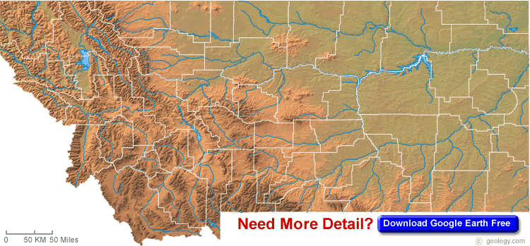
MONTANA BLANK PHYSICAL MAP
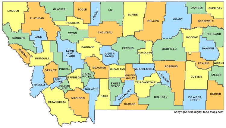
MONTANA COUNTY MAP
All Montana Cities Maps by Population
Billings Map -
(104,170)
Missoula Map -
(66,788)
Great Falls Map -
(58,505)
Bozeman Map -
(37,280)
Butte Silver Bow Map -
(33,525)
Helena Map -
(28,190)
Kalispell Map -
(19,927)
Havre Map -
(9,310)
Anaconda Deer Lodge Map -
(9,298)
Miles City Map -
(8,410)
Helena Valley Southeast Map -
(8,227)
Helena Valley West Central Map -
(7,883)
Evergreen Map -
(7,616)
Belgrade Map -
(7,389)
Livingston Map -
(7,044)
Lockwood Map -
(6,797)
Laurel Map -
(6,718)
Whitefish Map -
(6,357)
Lewistown Map -
(5,901)
Orchard Homes Map -
(5,197)
Sidney Map -
(5,191)
Glendive Map -
(4,935)
Columbia Falls Map -
(4,688)
Polson Map -
(4,488)
Hamilton Map -
(4,348)
Bigfork Map -
(4,270)
Dillon Map -
(4,134)
Lolo Map -
(3,892)
Hardin Map -
(3,505)
Helena Valley Northwest Map -
(3,482)
Malmstrom AFB Map -
(3,472)
Shelby Map -
(3,376)
Glasgow Map -
(3,250)
Four Corners Map -
(3,146)
Deer Lodge Map -
(3,111)
Helena Valley Northeast Map -
(2,995)
Cut Bank Map -
(2,869)
Montana City Map -
(2,715)
Lakeside Map -
(2,669)
Libby Map -
(2,628)
Wolf Point Map -
(2,621)
Conrad Map -
(2,570)
North Browning Map -
(2,408)
Big Sky Map -
(2,308)
Pablo Map -
(2,254)
Colstrip Map -
(2,214)
East Missoula Map -
(2,157)
Red Lodge Map -
(2,125)
Lame Deer Map -
(2,052)
Malta Map -
(1,997)
East Helena Map -
(1,984)
West Glendive Map -
(1,948)
Columbus Map -
(1,893)
Townsend Map -
(1,878)
Ronan Map -
(1,871)
Three Forks Map -
(1,869)
Frenchtown Map -
(1,825)
Stevensville Map -
(1,809)
Roundup Map -
(1,788)
South Browning Map -
(1,785)
Forsyth Map -
(1,777)
Baker Map -
(1,741)
Plentywood Map -
(1,734)
Choteau Map -
(1,684)
Bonner West Riverside Map -
(1,663)
Clancy Map -
(1,661)
Seeley Lake Map -
(1,659)
Big Timber Map -
(1,641)
Helena West Side Map -
(1,637)
Sun Prairie Map -
(1,630)
Crow Agency Map -
(1,616)
Manhattan Map -
(1,520)
Fort Benton Map -
(1,464)
Thompson Falls Map -
(1,313)
Fort Belknap Agency Map -
(1,293)
West Yellowstone Map -
(1,271)
Chinook Map -
(1,203)
Boulder Map -
(1,183)
Absarokee Map -
(1,150)
Somers Map -
(1,109)
Clinton Map -
(1,052)
Plains Map -
(1,048)
Helena Flats Map -
(1,043)
Whitehall Map -
(1,038)
Eureka Map -
(1,037)
Scobey Map -
(1,017)
Browning Map -
(1,016)
Lincoln Map -
(1,013)
Harlowton Map -
(997)
Park City Map -
(983)
Corvallis Map -
(976)
Pioneer Junction Map -
(959)
White Sulphur Springs Map -
(939)
Troy Map -
(938)
Pinesdale Map -
(917)
Black Eagle Map -
(904)
Churchill Map -
(902)
Rocky Boy West Map -
(890)
Marion Map -
(886)
Gardiner Map -
(875)
Gallatin Gateway Map -
(856)
Chester Map -
(847)
Hays Map -
(843)
St. Ignatius Map -
(842)
Fairview Map -
(840)
Ennis Map -
(838)
Hungry Horse Map -
(826)
Ashland Map -
(824)
Philipsburg Map -
(820)
Superior Map -
(812)
Poplar Map -
(810)
Harlem Map -
(808)
Florence Map -
(765)
Busby Map -
(745)
Victor Map -
(745)
Ulm Map -
(738)
King Arthur Park Map -
(738)
Darby Map -
(720)
Havre North Map -
(716)
Culbertson Map -
(714)
Fairfield Map -
(708)
Bridger Map -
(708)
Carlton Map -
(694)
Cascade Map -
(685)
Pray Map -
(681)
Walkerville Map -
(675)
Woods Bay Map -
(661)
Vaughn Map -
(658)
Sheridan Map -
(642)
Arlee Map -
(636)
Pryor Map -
(618)
Muddy Map -
(617)
Circle Map -
(615)
Terry Map -
(605)
Big Sandy Map -
(598)
Belt Map -
(597)
Joliet Map -
(595)
Wibaux Map -
(589)
Heart Butte Map -
(582)
Worden Map -
(577)
White Haven Map -
(577)
Wheatland Map -
(568)
Hot Springs Map -
(544)
Trego Map -
(541)
Coram Map -
(539)
South Hills Map -
(517)
Shepherd Map -
(516)
Wye Map -
(511)
Valier Map -
(509)
The Silos Map -
(506)
Martin City Map -
(500)
Emigrant Map -
(488)
Riverbend Map -
(484)
Finley Point Map -
(480)
Jefferson City Map -
(472)
Broadus Map -
(468)
Huntley Map -
(446)
Fromberg Map -
(438)
Lodge Grass Map -
(428)
Alberton Map -
(420)
Lewistown Heights Map -
(407)
Stanford Map -
(401)
Piltzville Map -
(395)
Midvale Map -
(393)
Kila Map -
(392)
Batavia Map -
(385)
Boneau Map -
(380)
Charlo Map -
(379)
Sunburst Map -
(375)
Twin Bridges Map -
(375)
West Kootenai Map -
(365)
East Glacier Park Village Map -
(363)
Rader Creek Map -
(363)
Frazer Map -
(362)
Roberts Map -
(361)
Spokane Creek Map -
(355)
Rocky Boy's Agency Map -
(355)
Simms Map -
(354)
St. Pierre Map -
(350)
Condon Map -
(343)
Jordan Map -
(343)
Parker School Map -
(340)
Ponderosa Pines Map -
(336)
Ekalaka Map -
(332)
Fortine Map -
(325)
Evaro Map -
(322)
Ballantine Map -
(320)
Knife River Map -
(320)
St. Regis Map -
(319)
Dutton Map -
(316)
West Havre Map -
(316)
Hysham Map -
(312)
Drummond Map -
(309)
Augusta Map -
(309)
Turah Map -
(306)
Sangrey Map -
(306)
Nashua Map -
(290)
Clyde Park Map -
(288)
Azure Map -
(286)
Kicking Horse Map -
(286)
South Glastonbury Map -
(284)
Lindisfarne Map -
(284)
Heron Map -
(282)
Fort Shaw Map -
(280)
Bear Dance Map -
(275)
Beaver Creek Map -
(271)
Lodge Pole Map -
(265)
St. Marie Map -
(264)
Geraldine Map -
(261)
Rudyard Map -
(258)
Wineglass Map -
(256)
Denton Map -
(255)
Brockton Map -
(255)
Jette Map -
(253)
Starr School Map -
(252)
Kerr Map -
(251)
Yaak Map -
(248)
Ryegate Map -
(245)
Trout Creek Map -
(242)
Fort Peck Map -
(233)
West Glacier Map -
(227)
Medicine Lake Map -
(225)
Lima Map -
(221)
Elliston Map -
(219)
Noxon Map -
(218)
Belfry Map -
(218)
Hinsdale Map -
(217)
Conner Map -
(216)
Wyola Map -
(215)
Hobson Map -
(215)
Basin Map -
(212)
Sand Coulee Map -
(212)
Willow Creek Map -
(210)
Huson Map -
(210)
Turtle Lake Map -
(209)
Rollins Map -
(209)
Winifred Map -
(208)
Bainville Map -
(208)
Little Browning Map -
(206)
Forest Hill Village Map -
(206)
Dixon Map -
(203)
Gibson Flats Map -
(199)
Saco Map -
(197)
Little Bitterroot Lake Map -
(194)
Reed Point Map -
(193)
Moore Map -
(193)
Broadview Map -
(192)
Olney Map -
(191)
Virginia City Map -
(190)
Lavina Map -
(187)
Froid Map -
(185)
Winnett Map -
(182)
Elmo Map -
(180)
Amsterdam Map -
(180)
Power Map -
(179)
Gildford Map -
(179)
Wilsall Map -
(178)
Big Arm Map -
(177)
Richey Map -
(177)
Highwood Map -
(176)
Babb Map -
(174)
Camp Three Map -
(173)
Stockett Map -
(169)
Klein Map -
(168)
Westby Map -
(168)
Fallon Map -
(164)
Happys Inn Map -
(164)
Paradise Map -
(163)
Lonepine Map -
(162)
Plevna Map -
(162)
Fort Smith Map -
(161)
Custer Map -
(159)
Belknap Map -
(158)
Fox Lake Map -
(158)
Joplin Map -
(157)
Kevin Map -
(154)
Kings Point Map -
(151)
Winston Map -
(147)
Brady Map -
(140)
Birney Map -
(137)
Harrison Map -
(137)
Maxville Map -
(130)
Springhill Map -
(130)
Saddle Butte Map -
(128)
Judith Gap Map -
(126)
Dodson Map -
(124)
Sun River Map -
(124)
Charlos Heights Map -
(120)
Pony Map -
(118)
Hingham Map -
(118)
Herron Map -
(116)
Edgar Map -
(114)
Swan Lake Map -
(113)
Santa Rita Map -
(113)
Greycliff Map -
(112)
Avon Map -
(111)
Rosebud Map -
(111)
Grass Range Map -
(110)
Corwin Springs Map -
(109)
Toston Map -
(108)
Roy Map -
(108)
Old Agency Map -
(107)
Rexford Map -
(105)
Alder Map -
(103)
Sylvanite Map -
(103)
Crane Map -
(102)
Logan Map -
(99)
Sedan Map -
(99)
Kremlin Map -
(98)
Wisdom Map -
(98)
Rocky Point Map -
(97)
Melstone Map -
(96)
Silesia Map -
(96)
Garrison Map -
(96)
Box Elder Map -
(87)
Geyser Map -
(87)
Dupuyer Map -
(86)
Opheim Map -
(85)
Loma Map -
(85)
Dayton Map -
(84)
Weeksville Map -
(83)
St. Xavier Map -
(83)
Ovando Map -
(81)
Marysville Map -
(80)
Bearcreek Map -
(79)
De Borgia Map -
(78)
Ravalli Map -
(76)
Cooke City Map -
(75)
Flaxville Map -
(71)
Hebgen Lake Estates Map -
(70)
Gallatin River Ranch Map -
(69)
Zortman Map -
(69)
Radersburg Map -
(66)
Lake Mary Ronan Map -
(65)
Whitewater Map -
(64)
Martinsdale Map -
(64)
Turner Map -
(61)
Musselshell Map -
(60)
Camas Map -
(58)
Sweet Grass Map -
(58)
Carter Map -
(58)
Jardine Map -
(57)
Inverness Map -
(55)
Neihart Map -
(51)
Antelope Map -
(51)
Cardwell Map -
(50)
Outlook Map -
(47)
Craig Map -
(43)
Shawmut Map -
(42)
Springdale Map -
(42)
Biddle Map -
(41)
Sula Map -
(37)
Boyd Map -
(35)
Bynum Map -
(31)
Indian Springs Map -
(31)
Bridger Map -
(30)
Alzada Map -
(29)
Niarada Map -
(27)
Stryker Map -
(26)
Reserve Map -
(23)
Silver Gate Map -
(20)
Ismay Map -
(19)
Roscoe Map -
(15)
Elkhorn Map -
(10)