With interactive Alabama Map, view regional highways maps, road situations, transportation, lodging guide, geographical map, physical maps and more information. On Alabama Map, you can view all states, regions, cities, towns, districts, avenues, streets and popular centers' satellite, sketch and terrain maps.
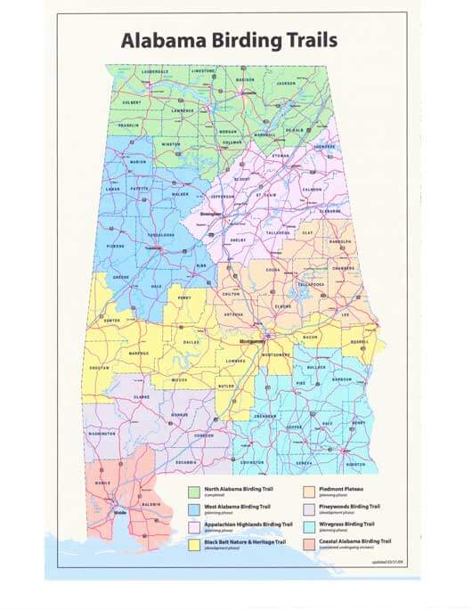
ALABAMA BIRDING TRAILS MAP
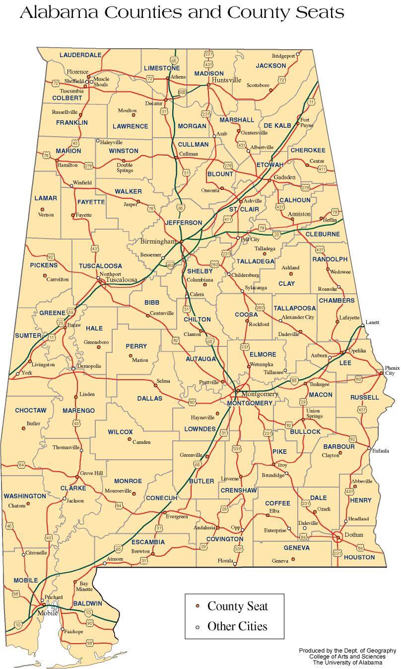
ALABAMA COUNTIES MAP
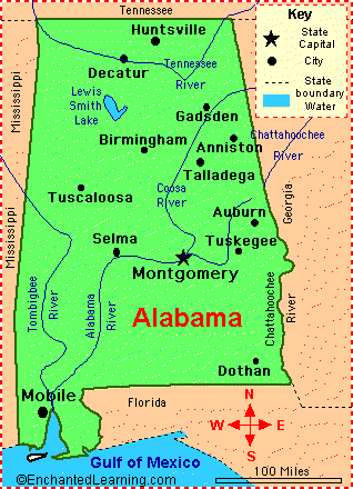
ALABAMA MAIN CITIES MAP
Embarking on a Southern Odyssey: The Enchanting Alabama Experience
Please subscribe on "World Guide" channnel on Youtube at youtube.com/c/WorldGuide
All Alabama Cities Maps by Population
Birmingham Map -
(212,237)
Montgomery Map -
(205,764)
Mobile Map -
(195,111)
Huntsville Map -
(180,105)
Tuscaloosa Map -
(90,468)
Hoover Map -
(81,619)
Dothan Map -
(65,496)
Decatur Map -
(55,683)
Auburn Map -
(53,380)
Madison Map -
(42,938)
Florence Map -
(39,319)
Gadsden Map -
(36,856)
Vestavia Hills Map -
(34,033)
Prattville Map -
(33,960)
Phenix City Map -
(32,822)
Alabaster Map -
(30,352)
Bessemer Map -
(27,456)
Enterprise Map -
(26,562)
Opelika Map -
(26,477)
Homewood Map -
(25,167)
Northport Map -
(23,330)
Anniston Map -
(23,106)
Prichard Map -
(22,659)
Athens Map -
(21,897)
Daphne Map -
(21,570)
Pelham Map -
(21,352)
Oxford Map -
(21,348)
Albertville Map -
(21,160)
Selma Map -
(20,756)
Mountain Brook Map -
(20,413)
Trussville Map -
(19,933)
Troy Map -
(18,033)
Tillmans Corner Map -
(17,398)
Center Point Map -
(16,921)
Helena Map -
(16,793)
Hueytown Map -
(16,105)
Talladega Map -
(15,676)
Fairhope Map -
(15,326)
Ozark Map -
(14,907)
Alexander City Map -
(14,875)
Cullman Map -
(14,775)
Scottsboro Map -
(14,770)
Millbrook Map -
(14,640)
Foley Map -
(14,618)
Jasper Map -
(14,352)
Hartselle Map -
(14,255)
Fort Payne Map -
(14,012)
Gardendale Map -
(13,893)
Saraland Map -
(13,405)
Muscle Shoals Map -
(13,146)
Eufaula Map -
(13,137)
Sylacauga Map -
(12,749)
Pell City Map -
(12,695)
Jacksonville Map -
(12,548)
Irondale Map -
(12,349)
Leeds Map -
(11,773)
Moody Map -
(11,726)
Calera Map -
(11,620)
Fairfield Map -
(11,117)
Saks Map -
(10,744)
Atmore Map -
(10,194)
Chelsea Map -
(10,183)
Forestdale Map -
(10,162)
Pleasant Grove Map -
(10,110)
Tuskegee Map -
(9,865)
Russellville Map -
(9,830)
Gulf Shores Map -
(9,741)
Clay Map -
(9,708)
Rainbow City Map -
(9,602)
Boaz Map -
(9,551)
Valley Map -
(9,524)
Sheffield Map -
(9,039)
Andalusia Map -
(9,015)
Meadowbrook Map -
(8,769)
Clanton Map -
(8,619)
Tuscumbia Map -
(8,423)
Southside Map -
(8,412)
Fultondale Map -
(8,380)
Guntersville Map -
(8,197)
Greenville Map -
(8,135)
Arab Map -
(8,050)
Bay Minette Map -
(8,044)
Demopolis Map -
(7,483)
Pinson Map -
(7,163)
Hamilton Map -
(6,885)
Spanish Fort Map -
(6,798)
Brook Highland Map -
(6,746)
Opp Map -
(6,659)
Oneonta Map -
(6,567)
Wetumpka Map -
(6,528)
Monroeville Map -
(6,519)
Lanett Map -
(6,468)
Tarrant Map -
(6,397)
Montevallo Map -
(6,323)
Lincoln Map -
(6,266)
Satsuma Map -
(6,168)
Theodore Map -
(6,130)
Chickasaw Map -
(6,106)
Roanoke Map -
(6,074)
Attalla Map -
(6,048)
Meridianville Map -
(6,021)
Grayson Valley Map -
(5,736)
Moores Mill Map -
(5,682)
Orange Beach Map -
(5,441)
Brewton Map -
(5,408)
Pike Road Map -
(5,406)
Midfield Map -
(5,365)
Daleville Map -
(5,295)
Harvest Map -
(5,281)
Robertsdale Map -
(5,276)
Jackson Map -
(5,228)
Childersburg Map -
(5,175)
Glencoe Map -
(5,160)
Rainsville Map -
(4,948)
Brent Map -
(4,947)
Smiths Station Map -
(4,926)
Piedmont Map -
(4,878)
Tallassee Map -
(4,819)
Winfield Map -
(4,717)
Fort Rucker Map -
(4,636)
Fayette Map -
(4,619)
Adamsville Map -
(4,522)
Headland Map -
(4,510)
Geneva Map -
(4,452)
Margaret Map -
(4,428)
Hokes Bluff Map -
(4,286)
Thomasville Map -
(4,209)
Columbiana Map -
(4,197)
Pine Level Map -
(4,183)
Haleyville Map -
(4,173)
Holtville Map -
(4,096)
Springville Map -
(4,080)
Mount Olive Map -
(4,079)
Argo Map -
(4,071)
Valley Grande Map -
(4,020)
Union Springs Map -
(3,980)
Evergreen Map -
(3,944)
Elba Map -
(3,940)
Highland Lakes Map -
(3,926)
Alexandria Map -
(3,917)
Citronelle Map -
(3,905)
Redland Map -
(3,736)
Marion Map -
(3,686)
Grand Bay Map -
(3,672)
Holt Map -
(3,638)
Hazel Green Map -
(3,630)
Odenville Map -
(3,585)
Centre Map -
(3,489)
Livingston Map -
(3,485)
Heflin Map -
(3,480)
Moulton Map -
(3,471)
West End Cobb Town Map -
(3,465)
Underwood Petersville Map -
(3,247)
Dadeville Map -
(3,230)
Warrior Map -
(3,176)
Red Bay Map -
(3,158)
Ladonia Map -
(3,142)
Weaver Map -
(3,038)
Clayton Map -
(3,008)
La Fayette Map -
(3,003)
Hanceville Map -
(2,982)
Brighton Map -
(2,945)
Eutaw Map -
(2,934)
New Hope Map -
(2,810)
Choccolocco Map -
(2,804)
Luverne Map -
(2,800)
Centreville Map -
(2,778)
Kimberly Map -
(2,711)
Abbeville Map -
(2,688)
Selmont West Selmont Map -
(2,671)
Priceville Map -
(2,658)
Hartford Map -
(2,624)
Jemison Map -
(2,585)
Emerald Mountain Map -
(2,561)
Bayou La Batre Map -
(2,558)
Huguley Map -
(2,540)
York Map -
(2,538)
Sumiton Map -
(2,520)
Greensboro Map -
(2,497)
Aliceville Map -
(2,486)
East Brewton Map -
(2,478)
Moundville Map -
(2,427)
Bridgeport Map -
(2,418)
Lineville Map -
(2,395)
Guin Map -
(2,376)
Taylor Map -
(2,375)
Indian Springs Village Map -
(2,363)
Henagar Map -
(2,344)
Midland City Map -
(2,344)
Good Hope Map -
(2,264)
Ashville Map -
(2,212)
Lipscomb Map -
(2,210)
Riverside Map -
(2,208)
Kinsey Map -
(2,198)
Graysville Map -
(2,165)
Ashford Map -
(2,148)
Whitesboro Map -
(2,138)
Carlisle Rockledge Map -
(2,137)
Point Clear Map -
(2,125)
Linden Map -
(2,123)
Trinity Map -
(2,095)
Cordova Map -
(2,095)
Level Plains Map -
(2,085)
Brundidge Map -
(2,076)
Stevenson Map -
(2,046)
Ashland Map -
(2,037)
Dora Map -
(2,025)
Carbon Hill Map -
(2,021)
Camden Map -
(2,020)
Vernon Map -
(2,000)
Vincent Map -
(1,988)
Collinsville Map -
(1,983)
Thorsby Map -
(1,980)
Florala Map -
(1,980)
Slocomb Map -
(1,980)
Redstone Arsenal Map -
(1,946)
Lake View Map -
(1,943)
Samson Map -
(1,940)
Sulligent Map -
(1,927)
Creola Map -
(1,926)
Butler Map -
(1,894)
Cowarts Map -
(1,871)
Crossville Map -
(1,862)
Morris Map -
(1,859)
Sylvania Map -
(1,837)
Concord Map -
(1,837)
Brookwood Map -
(1,828)
Wilsonville Map -
(1,827)
Smoke Rise Map -
(1,825)
Cedar Bluff Map -
(1,820)
Uniontown Map -
(1,775)
Stewartville Map -
(1,767)
Gordo Map -
(1,750)
Georgiana Map -
(1,738)
Sardis City Map -
(1,704)
Reform Map -
(1,702)
Blountsville Map -
(1,684)
Coaling Map -
(1,657)
Ragland Map -
(1,639)
Harpersville Map -
(1,637)
Loxley Map -
(1,632)
Lookout Mountain Map -
(1,621)
New Market Map -
(1,597)
Ballplay Map -
(1,580)
Mount Vernon Map -
(1,574)
Grove Hill Map -
(1,570)
Sylvan Springs Map -
(1,542)
Vance Map -
(1,529)
Owens Cross Roads Map -
(1,521)
Hackleburg Map -
(1,516)
Newton Map -
(1,511)
Elberta Map -
(1,498)
Goodwater Map -
(1,475)
Rock Creek Map -
(1,456)
Malvern Map -
(1,448)
Flomaton Map -
(1,440)
Webb Map -
(1,430)
Woodstock Map -
(1,428)
Marbury Map -
(1,418)
Shoal Creek Map -
(1,400)
Clio Map -
(1,399)
Coats Bend Map -
(1,394)
Brookside Map -
(1,363)
Fort Deposit Map -
(1,344)
Blue Ridge Map -
(1,341)
Frisco City Map -
(1,309)
Cleveland Map -
(1,303)
Rehobeth Map -
(1,297)
Munford Map -
(1,292)
Cottonwood Map -
(1,289)
Chatom Map -
(1,288)
Fayetteville Map -
(1,284)
Mignon Map -
(1,284)
Falkville Map -
(1,279)
Westover Map -
(1,275)
Elmore Map -
(1,262)
Rogersville Map -
(1,257)
Tidmore Bend Map -
(1,245)
West Blocton Map -
(1,240)
Dauphin Island Map -
(1,238)
Coosada Map -
(1,224)
Ardmore Map -
(1,194)
Locust Fork Map -
(1,186)
Ohatchee Map -
(1,170)
Deatsville Map -
(1,154)
Berry Map -
(1,148)
Phil Campbell Map -
(1,148)
New Brockton Map -
(1,146)
Vandiver Map -
(1,135)
Killen Map -
(1,108)
Town Creek Map -
(1,100)
Minor Map -
(1,094)
Double Springs Map -
(1,083)
Bear Creek Map -
(1,070)
Millport Map -
(1,049)
Cherokee Map -
(1,048)
Shelby Map -
(1,044)
Steele Map -
(1,043)
Mosses Map -
(1,029)
Leesburg Map -
(1,027)
Carrollton Map -
(1,019)
Fyffe Map -
(1,018)
Camp Hill Map -
(1,014)
Littleville Map -
(1,011)
Eclectic Map -
(1,001)
Hollywood Map -
(1,000)
Parrish Map -
(982)
Dunnavant Map -
(981)
Coker Map -
(979)
Pine Hill Map -
(975)
Notasulga Map -
(965)
New Union Map -
(955)
Powell Map -
(955)
Altoona Map -
(933)
Hayneville Map -
(932)
Egypt Map -
(932)
Leroy Map -
(911)
Brilliant Map -
(900)
Grant Map -
(896)
Geraldine Map -
(896)
Brantleyville Map -
(884)
Edgewater Map -
(883)
Ivalee Map -
(879)
Autaugaville Map -
(870)
Summerdale Map -
(862)
White Hall Map -
(858)
Gallant Map -
(855)
Skyline Map -
(851)
Mulga Map -
(836)
Snead Map -
(835)
Jacksons Gap Map -
(828)
Wedowee Map -
(823)
White Plains Map -
(811)
Brantley Map -
(809)
Gurley Map -
(801)
Holly Pond Map -
(798)
Oakman Map -
(789)
New Site Map -
(773)
Hobson City Map -
(771)
Section Map -
(770)
Reeltown Map -
(766)
Ariton Map -
(764)
Susan Moore Map -
(763)
Addison Map -
(758)
Axis Map -
(757)
Wadley Map -
(751)
South Vinemont Map -
(749)
Woodville Map -
(746)
Douglas Map -
(744)
Columbia Map -
(740)
Lexington Map -
(735)
Leighton Map -
(729)
Somerville Map -
(724)
Magnolia Springs Map -
(723)
Ider Map -
(723)
Excel Map -
(723)
Pisgah Map -
(722)
McDonald Chapel Map -
(717)
Sterrett Map -
(712)
Maplesville Map -
(708)
Silverhill Map -
(706)
Walnut Grove Map -
(698)
Wilton Map -
(687)
Bristow Cove Map -
(683)
Lynn Map -
(659)
Hissop Map -
(658)
Reece City Map -
(653)
Forkland Map -
(649)
Pinckard Map -
(647)
Trafford Map -
(646)
Our Town Map -
(641)
North Courtland Map -
(632)
Allgood Map -
(622)
Baileyton Map -
(610)
Courtland Map -
(609)
Pickensville Map -
(608)
Belle Fontaine Map -
(608)
Hollis Crossroads Map -
(608)
Babbie Map -
(603)
Rock Mills Map -
(600)
Dodge City Map -
(593)
Clayhatchee Map -
(589)
West Point Map -
(586)
Castleberry Map -
(583)
Perdido Beach Map -
(581)
Sand Rock Map -
(560)
Valley Head Map -
(558)
Grimes Map -
(558)
Hurtsboro Map -
(553)
Hillsboro Map -
(552)
Millry Map -
(546)
Hollins Map -
(545)
Avon Map -
(543)
Bellamy Map -
(543)
Kinston Map -
(540)
Newville Map -
(539)
Lisman Map -
(539)
McKenzie Map -
(530)
Oak Grove Map -
(528)
River Falls Map -
(526)
Louisville Map -
(519)
Eva Map -
(519)
Lockhart Map -
(516)
Glen Allen Map -
(510)
Joppa Map -
(501)
Midway Map -
(499)
Triana Map -
(496)
St. Stephens Map -
(495)
Garden City Map -
(492)
Hammondville Map -
(488)
Red Level Map -
(487)
Rockford Map -
(477)
Shorter Map -
(474)
Rutledge Map -
(467)
Silas Map -
(452)
Kennedy Map -
(447)
Fairview Map -
(446)
Hayden Map -
(444)
Ray Map -
(443)
Sipsey Map -
(437)
Elkmont Map -
(434)
Pleasant Groves Map -
(420)
Thomaston Map -
(417)
St. Florian Map -
(413)
Highland Lake Map -
(412)
Ranburne Map -
(409)
Nances Creek Map -
(407)
Twin Map -
(399)
Maytown Map -
(385)
Mount Olive Map -
(371)
Mentone Map -
(360)
Vina Map -
(358)
Arley Map -
(357)
Akron Map -
(356)
Hytop Map -
(354)
Napier Field Map -
(354)
Coffeeville Map -
(352)
Madrid Map -
(350)
Hackneyville Map -
(347)
Cuba Map -
(346)
Nectar Map -
(345)
West Jefferson Map -
(338)
Gordon Map -
(332)
Dozier Map -
(329)
Boligee Map -
(328)
Gordonville Map -
(326)
Rosa Map -
(316)
Dutton Map -
(315)
Vredenburgh Map -
(312)
Movico Map -
(305)
Beatrice Map -
(301)
Carolina Map -
(297)
Uriah Map -
(294)
Macedonia Map -
(292)
Hodges Map -
(288)
Fruithurst Map -
(284)
Waldo Map -
(283)
Pine Ridge Map -
(282)
Repton Map -
(282)
Weogufka Map -
(282)
Anderson Map -
(282)
Bakerhill Map -
(279)
Millerville Map -
(278)
Calvert Map -
(277)
Boykin Map -
(275)
Shiloh Map -
(274)
Fulton Map -
(272)
Langston Map -
(270)
Colony Map -
(268)
Goshen Map -
(266)
Hatton Map -
(261)
County Line Map -
(258)
Sweet Water Map -
(258)
Heath Map -
(254)
Eunola Map -
(243)
Sanford Map -
(241)
Spring Garden Map -
(238)
McIntosh Map -
(238)
Detroit Map -
(237)
Union Map -
(237)
Horn Hill Map -
(228)
Coffee Springs Map -
(228)
Kansas Map -
(226)
Providence Map -
(223)
Spruce Pine Map -
(222)
Gantt Map -
(222)
Nauvoo Map -
(221)
Pennington Map -
(221)
Morrison Crossroads Map -
(219)
Kellyton Map -
(217)
Belk Map -
(215)
Gilbertown Map -
(215)
Daviston Map -
(214)
Graham Map -
(211)
Chunchula Map -
(210)
Paint Rock Map -
(210)
Gainesville Map -
(208)
Black Map -
(207)
Orrville Map -
(204)
Waterloo Map -
(203)
Edwardsville Map -
(202)
Penton Map -
(201)
East Point Map -
(201)
Beaverton Map -
(201)
Fredonia Map -
(199)
Delta Map -
(197)
Putnam Map -
(193)
Vinegar Bend Map -
(192)
Epes Map -
(192)
Abanda Map -
(192)
Deer Park Map -
(188)
Yellow Bluff Map -
(188)
Glenwood Map -
(187)
Malcolm Map -
(187)
Newbern Map -
(186)
Fairford Map -
(186)
Fruitdale Map -
(185)
Onycha Map -
(184)
Woodland Map -
(184)
Riverview Map -
(184)
Broomtown Map -
(182)
Loachapoka Map -
(180)
Banks Map -
(179)
Gu Win Map -
(176)
Cullomburg Map -
(171)
Geiger Map -
(170)
Standing Rock Map -
(168)
Talladega Springs Map -
(166)
Gulfcrest Map -
(161)
Sims Chapel Map -
(153)
Whatley Map -
(150)
Franklin Map -
(149)
North Johns Map -
(145)
Waverly Map -
(145)
Panola Map -
(144)
Gaylesville Map -
(144)
Billingsley Map -
(144)
Lakeview Map -
(143)
Five Points Map -
(141)
Pollard Map -
(137)
Toxey Map -
(137)
Pine Apple Map -
(132)
Eldridge Map -
(130)
Myrtlewood Map -
(130)
Belgreen Map -
(129)
Hobson Map -
(126)
Cusseta Map -
(123)
Libertyville Map -
(117)
Bon Air Map -
(116)
Lowndesboro Map -
(115)
Ridgeville Map -
(112)
Lester Map -
(111)
Haleburg Map -
(103)
Faunsdale Map -
(98)
Blue Springs Map -
(96)
Nanafalia Map -
(94)
Needham Map -
(94)
Peterman Map -
(89)
Fitzpatrick Map -
(83)
Ethelsville Map -
(81)
Union Grove Map -
(77)
Carlton Map -
(65)
Megargel Map -
(62)
Petrey Map -
(58)
Goldville Map -
(55)
Cardiff USA Map -
(55)
Emelle Map -
(53)
Mooresville Map -
(53)
Dayton Map -
(52)
Benton Map -
(49)
Rockville Map -
(43)
Tibbie Map -
(41)
Natural Bridge Map -
(37)
Bucks Map -
(32)
Memphis Map -
(29)
Oak Hill Map -
(26)
Catherine Map -
(22)
McMullen Map -
(10)