New York Population Map
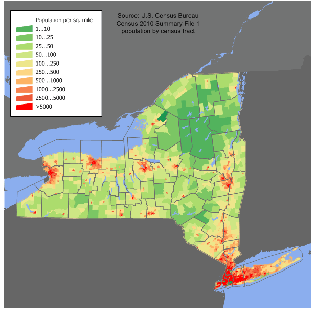
The distribution of change in population growth is uneven in New York State; the New York City metropolitan area is growing considerably, along with Saratoga County, while most of Western New York is nearly stagnant.
For New York Population Map Map, Direction, Location and Where Addresse
| Historical population | |||
|---|---|---|---|
| Census | Pop. | %± | |
| 1790 | 340,120 | — | |
| 1800 | 589,051 | 73.2% | |
| 1810 | 959,049 | 62.8% | |
| 1820 | 1,372,812 | 43.1% | |
| 1830 | 1,918,608 | 39.8% | |
| 1840 | 2,428,921 | 26.6% | |
| 1850 | 3,097,394 | 27.5% | |
| 1860 | 3,880,735 | 25.3% | |
| 1870 | 4,382,759 | 12.9% | |
| 1880 | 5,082,871 | 16.0% | |
| 1890 | 6,003,174 | 18.1% | |
| 1900 | 7,268,894 | 21.1% | |
| 1910 | 9,113,614 | 25.4% | |
| 1920 | 10,385,227 | 14.0% | |
| 1930 | 12,588,066 | 21.2% | |
| 1940 | 13,479,142 | 7.1% | |
| 1950 | 14,830,192 | 10.0% | |
| 1960 | 16,782,304 | 13.2% | |
| 1970 | 18,236,967 | 8.7% | |
| 1980 | 17,558,072 | -3.7% | |
| 1990 | 17,990,455 | 2.5% | |
| 2000 | 18,976,457 | 5.5% | |
| 2010 | 19,378,102 | 2.1% | |
| Est. 2014 | 19,746,227 | 1.9% | |
| Sources:
2014 Estimate |
|||
Largest Cities Map of New York and Population
- New York City Map - 8.175.133 - (40.714,-74.006)
- Brooklyn Map - 2.300.664 - (40.65,-73.95)
- Manhattan Map - 1.487.536 - (40.783,-73.966)
- Buffalo Map - 261.310 - (42.886,-78.878)
- Rochester Map - 210.565 - (43.155,-77.616)
- Yonkers Map - 195.976 - (40.931,-73.899)
- Syracuse Map - 145.170 - (43.048,-76.147)
- Albany Map - 97.856 - (42.653,-73.756)
- New Rochelle Map - 77.062 - (40.91148820000,-73.78235490000)
- Cheektowaga Map - 75.178 - (42.90261360000,-78.74457200000)
- Mount Vernon Map - 67.292 - (40.91259920000,-73.83707860000)
- Schenectady Map - 66.135 - (42.81424320000,-73.93956870000)
- Utica Map - 62.235 - (43.100903, -75.232664)
- Brentwood Map - 60.664 - (40.781209, -73.246227)
- Tonawanda Map - 58.144 - (42.981389, -78.855278)
- White Plains Map - 56.853 - (41.033986, -73.762910)
- Hempstead Map - 53.891 - (40.706213, -73.618740)
- Levittown Map - 51.881 - (40.725934, -73.514292)
- Irondequoit Map - 51.692 - (43.213395, -77.579723)
- Niagara Falls Map - 50.193 - (43.096214, -79.037739)
- Troy Map - 50.129 - (42.728412, -73.691785)
- Binghamton Map - 47.376 - (42.098687, -75.917974)
- West Seneca Map - 44.711 - (42.850059, -78.799755)
- West Babylon Map - 43.213 - (40.718155, -73.354287)
- Freeport Map - 42.860 - (40.657602, -73.583184)
- Hicksville Map - 41.547 - (40.768433, -73.525125)
- Coram Map - 39.113 - (40.868710, -73.001495)
- East Meadow Map - 38.132 - (40.713990, -73.559016)
- Valley Stream Map - 37.511 - (40.664270, -73.708465)
- Brighton Map - 36.609 - (43.118590, -77.584391)
Click for New York Population Map Direction »
Click for New York Population Map Street View »
Copyright Turkey Travel Guide - 2005 - 2026. All rights reserved. Privacy Policy | Disclaimer