Pennsylvania National Atlas USA
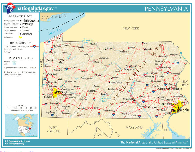
Map of Pennsylvania, showing major cities and roads. he Pennsylvania Department of Transportation, abbreviated as PennDOT, owns 39,861 miles (64,150 km) of the 121,770 miles (195,970 km) of roadway in the state, making it the fifth largest state highway system in the United States.
For Pennsylvania National Atlas USA Map, Direction, Location and Where Addresse
Largest Cities Map of Pennsylvania and Population
- Philadelphia Map - 1.526.006 - (39.952335, -75.163789)
- Pittsburgh Map - 305.704 - (40.441,-79.996)
- Allentown Map - 118.032 - (40.608,-75.49)
- Erie Map - 101.786 - (42.129,-80.085)
- Reading Map - 88.082 - (40.336,-75.927)
- Scranton Map - 76.089 - (41.409,-75.662)
- Bethlehem Map - 74.982 - (40.626,-75.37)
- Lancaster Map - 59.322 - (40.038,-76.306)
- Levittown Map - 52.983 - (40.155,-74.829)
- Harrisburg Map - 49.528 - (40.274,-76.884)
- Altoona Map - 46.320 - (40.518681, -78.394736)
- York Map - 43.718 - (39.962598, -76.727745)
- Penn Hills Township Map - 42.329 - (40.478781, -79.818468)
- State College Map - 42.034 - (40.793395, -77.860001)
- Wilkes Barre Map - 41.498 - (41.245915, -75.881308)
- Norristown Map - 34.324 - (40.121497, -75.339905)
- Chester Map - 33.972 - (39.849557, -75.355746)
- Mount Lebanon Township Map - 33.137 - (40.372771, -80.047904)
- Bethel Park Map - 32.313 - (40.327570, -80.039498)
- Radnor Township Map - 31.531 - (40.028344, -75.368307)
Click for Pennsylvania National Atlas USA Direction »
Click for Pennsylvania National Atlas USA Street View »
Copyright Turkey Travel Guide - 2005 - 2026. All rights reserved. Privacy Policy | Disclaimer