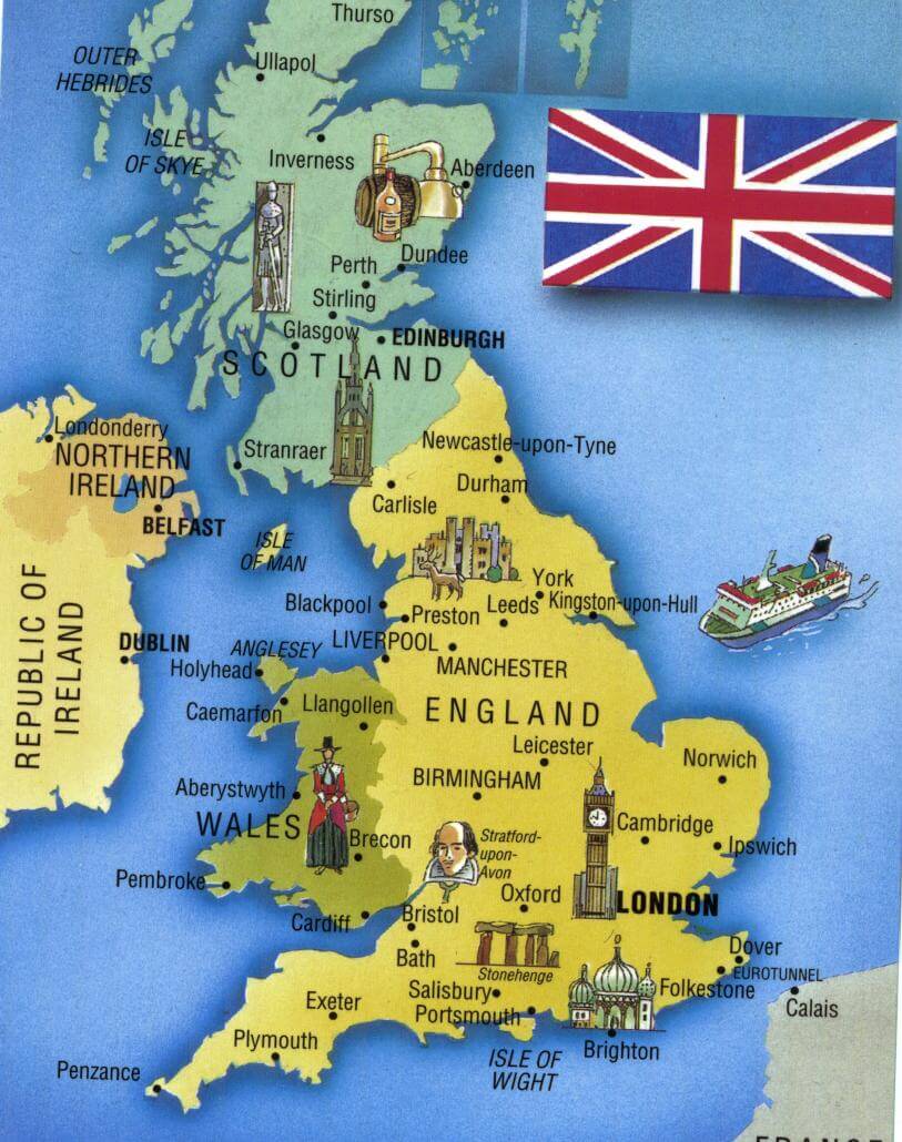
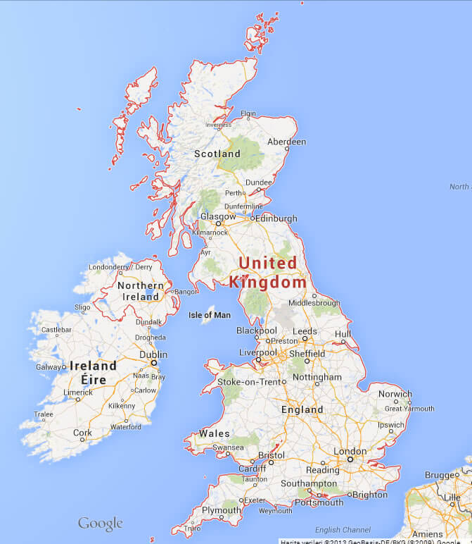
UK Map - United Kingdom Map
N avigate UK Map, United Kingdom countries map, satellite images of United Kingdom, UK largest cities maps, political map of United Kingdom, driving directions and traffic maps.

- Capital : London
- Population : 63,181,775
- GDP : $2.434 trillion (7th)
- Per Capita : $38,591
- Calling Code : +44
- Jobless Rate : 7.70%
- Time Zone : +0
United Kingdom Google Map, Street Views, Maps Directions, Satellite Images
Please Not : You can find local businesses, public places, tourist attractions via map view, satellite image, hybrid view, driving directions in UK Map. You'll also find a varity map of United Kingdom such as political, administrative, transportation, demographics maps following Google map.
Submit URL to UK :
United Kingdom Map & UK Satellite Images

Largest Cities Map of UK
- London Map
- Manchester Map
- Liverpool Map
- Aberdeen Map
- Belfast Map
- Birmingham Map
- Blackburn Map
- Bolton Map
- Bradford Map
- Bristol Map
- Cardiff Map
- Coventry Map
- Derby Map
- Edinburgh Map
- Glasgow Map
- Huddersfield Map
- Ipswich Map
- Kingston Upon Hull Map
- Leeds Map
- Leicester Map
- Middlesbrough Map
- Newcastle Map
- Northampton Map
- Norwich Map
- Oxford Map
- Peterborough Map
- Plymouth Map
- Portsmouth Map
- Reading Map
- Sheffield Map
- Southampton Map
- Stoke on Trent Map
- Sunderland Map
- Swansea Map
- Walsall Map
- Watford Map
- West Bromwich Map
- Wolverhampton Map
A collection of UK (United Kingdom - England, North Ireland, Scotland, Wales)
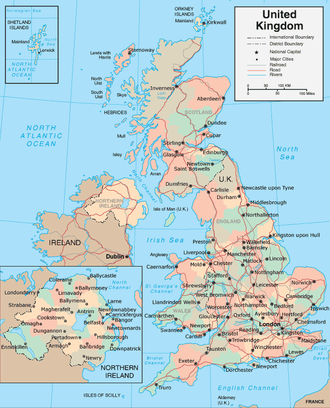


Alphabetically Cities Map of United Kingdom & Population of United Kingdom Cities
- London Map - 7,172,091
- Birmingham Map - 970,892
- Glasgow Map - 629,501
- Liverpool Map - 469,017
- Leeds Map - 443,247
- Sheffield Map - 439,866
- Edinburgh Map - 430,082
- Bristol Map - 420,556
- Manchester Map - 394,269
- Leicester Map - 330,574
- Coventry Map - 303,475
- Kingston Upon Hull Map - 301,416
- Bradford Map - 293,717
- Cardiff Map - 292,150
- Belfast Map - 276,459
- Stoke on Trent Map - 259,252
- Wolverhampton Map - 251,462
- Nottingham Map - 249,584
- Plymouth Map - 243,795
- Southampton Map - 234,224
- Reading Map - 232,662
- Derby Map - 229,407
- Dudley Map - 194,619
- Northampton Map - 189,474
- Portsmouth Map - 187,056
- Luton Map - 185,543
- Preston Map - 184,836
- Aberdeen Map - 184,788
- Milton Keynes Map - 184,506
- Sunderland Map - 177,739
- Norwich Map - 174,047
- Walsall Map - 170,994
- Bournemouth Map - 167,527
- Southend on Sea Map - 160,257
- Swindon Map - 155,432
- Dundee Map - 154,674
- Huddersfield Map - 146,234
- Poole Map - 144,800
- Oxford Map - 143,016
- Middlesbrough Map - 142,691
- Blackpool Map - 142,283
- Bolton Map - 139,403
- Ipswich Map - 138,718
- Telford Map - 138,241
- York Map - 137,505
- Peterborough Map - 136,292
- Stockport Map - 136,082
- Brighton Map - 134,293
- Slough Map - 126,276
- Gloucester Map - 123,205
- Rotherham Map - 117,262
- Newport Map - 116,143
- Cambridge Map - 113,442
- Exeter Map - 106,772
- Eastbourne Map - 106,562
- Sutton Coldfield Map - 105,452
- Blackburn Map - 105,085
- Colchester Map - 104,390
- Oldham Map - 103,544
- St Helens Map - 102,629
- Woking Map - 101,127
- Crawley Map - 100,547
- Chelmsford Map - 99,962
- Basildon Map - 99,876
- Cheltenham Map - 98,875
- Gillingham Map - 98,403
- Worthing Map - 96,964
- Rochdale Map - 95,796
- Solihull Map - 94,753
- Worcester Map - 94,100
- Derry Map - 93,512
- Southport Map - 91,404
- Basingstoke Map - 90,171
- Bath Map - 90,144
- Maidstone Map - 89,684
- Harlow Map - 88,296
- Grimsby Map - 87,574
- Darlington Map - 86,082
- Hartlepool Map - 86,075
- Lincoln Map - 85,963
- Hastings Map - 85,828
- Birkenhead Map - 83,729
- Halifax Map - 83,570
- Hemel Hempstead Map - 83,118
- South Shields Map - 82,854
- Bedford Map - 82,488
- St Albans Map - 82,429
- Stevenage Map - 81,482
- Wigan Map - 81,203
- Warrington Map - 80,661
- Chester Map - 80,121
- Stockton on Tees Map - 80,060
- Gateshead Map - 78,403
- Weston super Mare Map - 78,044
- High Wycombe Map - 77,178
- Wakefield Map - 76,886
- Redditch Map - 74,803
- Newcastle under Lyme Map - 74,427
- Newcastle Map - 74,427
- Paisley Map - 74,170
- East Kilbride Map - 73,796
- Chatham Map - 73,468
- Burnley Map - 73,021
- Salford Map - 72,750
- Scunthorpe Map - 72,514
- Hove Map - 72,335
- Carlisle Map - 71,773
- Tamworth Map - 71,650
- Barnsley Map - 71,599
- Harrogate Map - 71,594
- Lisburn Map - 71,465
- Bracknell Map - 70,795
- Nuneaton Map - 70,721
- Chesterfield Map - 70,260
- Mansfield Map - 69,987
- Guildford Map - 69,400
- Gosport Map - 69,348
- Aylesbury Map - 69,021
- Lowestoft Map - 68,340
- Doncaster Map - 67,977
- Crewe Map - 67,683
- Shrewsbury Map - 67,126
- Ellesmere Port Map - 66,265
- Cannock Map - 65,022
- Grays Map - 64,173
- Torquay Map - 63,998
- Stafford Map - 63,681
- Waterlooville Map - 63,558
- Kingswood Map - 62,679
- Bognor Regis Map - 62,141
- Newtownabbey Map - 62,056
- Rugby Map - 61,988
- Royal Leamington Spa Map - 61,595
- Bury Map - 60,718
- Royal Tunbridge Wells Map - 60,095
- Runcorn Map - 60,072
- Rhondda Map - 59,602
- Bootle Map - 59,123
- Ashford Map - 58,936
- Maidenhead Map - 58,848
- Wallasey Map - 58,710
- Margate Map - 58,465
- Bangor Map - 58,388
- Taunton Map - 58,241
- Aldershot Map - 58,170
- Great Yarmouth Map - 58,032
- Farnborough Map - 57,147
- Bebington Map - 57,066
- Dartford Map - 56,818
- Hereford Map - 56,373
- Fareham Map - 56,160
- Littlehampton Map - 55,716
- Widnes Map - 55,686
- Stourbridge Map - 55,480
- Kidderminster Map - 55,348
- Cheshunt Map - 55,275
- Halesowen Map - 55,273
- Loughborough Map - 55,258
- Sale Map - 55,234
- Dewsbury Map - 54,341
- Morley Map - 54,051
- Washington UK Map - 53,388
- Gravesend Map - 53,388
- Eastleigh Map - 52,894
- Crosby Map - 51,789
- Clacton on Sea Map - 51,284
- Kettering Map - 51,063
- Livingston Map - 50,826
- Dunstable Map - 50,775
- Macclesfield Map - 50,688
- Barry Map - 50,661
- Staines Map - 50,538
- Swansea Map - 16,988
- West Bromwich Map - 13,694
- Watford Map - 12,096
- Homeland Park Map - 6,296
- Homeland Map - 5,969
- Homeland Map - 910
- Homeland Map - 366
Copyright Turkey Travel Guide - 2005 - 2025. All rights reserved. Privacy Policy | Disclaimer