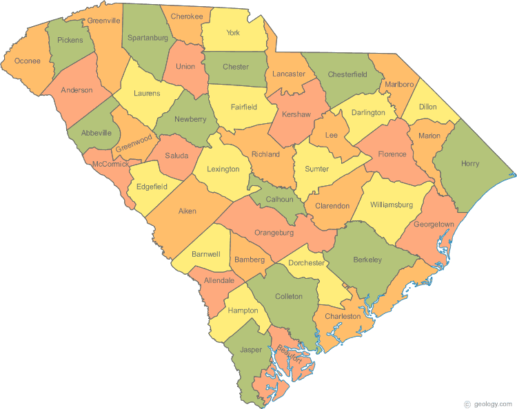
South Carolina Map
N avigate South Carolina Map, South Carolina states map, satellite images of the South Carolina, South Carolina largest cities maps, political map of South Carolina, driving directions and traffic maps.
All South Carolina Cities Maps by Population
- Columbia Map - (129,272)
- Charleston Map - (120,083)
- North Charleston Map - (97,471)
- Mount Pleasant Map - (67,843)
- Rock Hill Map - (66,154)
- Greenville Map - (58,409)
- Summerville Map - (43,392)
- Sumter Map - (40,524)
- Hilton Head Island Map - (37,099)
- Florence Map - (37,056)
- Spartanburg Map - (37,013)
- Goose Creek Map - (35,938)
- Aiken Map - (29,524)
- Myrtle Beach Map - (27,109)
- Anderson Map - (26,686)
- Greer Map - (25,515)
- Greenwood Map - (23,222)
- Mauldin Map - (22,889)
- Taylors Map - (21,617)
- North Augusta Map - (21,348)
- Wade Hampton Map - (20,622)
- St. Andrews Map - (20,493)
- Easley Map - (19,993)
- Socastee Map - (19,952)
- Simpsonville Map - (18,238)
- Hanahan Map - (17,997)
- Lexington Map - (17,870)
- Conway Map - (17,103)
- Seven Oaks Map - (15,144)
- West Columbia Map - (14,988)
- Berea Map - (14,295)
- Gantt Map - (14,229)
- Five Forks Map - (14,140)
- Dentsville Map - (14,062)
- Orangeburg Map - (13,964)
- Clemson Map - (13,905)
- Ladson Map - (13,790)
- North Myrtle Beach Map - (13,752)
- Red Hill Map - (13,223)
- Bluffton Map - (12,530)
- Cayce Map - (12,528)
- Gaffney Map - (12,414)
- Beaufort Map - (12,361)
- Parker Map - (11,431)
- Irmo Map - (11,097)
- Fort Mill Map - (10,811)
- Port Royal Map - (10,678)
- Forest Acres Map - (10,361)
- Oak Grove Map - (10,291)
- Newberry Map - (10,277)
- Red Bank Map - (9,617)
- Woodfield Map - (9,303)
- Garden City Map - (9,209)
- Georgetown Map - (9,163)
- Laurens Map - (9,139)
- Bennettsville Map - (9,069)
- Little River Map - (8,960)
- Lake Wylie Map - (8,841)
- Lancaster Map - (8,526)
- Clinton Map - (8,490)
- Union Map - (8,393)
- Sangaree Map - (8,220)
- Boiling Springs Map - (8,219)
- Seneca Map - (8,102)
- Moncks Corner Map - (7,885)
- Sans Souci Map - (7,869)
- Fountain Inn Map - (7,799)
- Hartsville Map - (7,764)
- York Map - (7,736)
- Tega Cay Map - (7,620)
- Powdersville Map - (7,618)
- Murrells Inlet Map - (7,547)
- Lugoff Map - (7,434)
- Burton Map - (6,976)
- Marion Map - (6,939)
- Camden Map - (6,838)
- Dillon Map - (6,788)
- Lake City Map - (6,675)
- Welcome Map - (6,668)
- Centerville Map - (6,586)
- Valley Falls Map - (6,299)
- Homeland Park Map - (6,296)
- Darlington Map - (6,289)
- Laurel Bay Map - (5,891)
- Cheraw Map - (5,851)
- Belvedere Map - (5,792)
- Chester Map - (5,607)
- Lake Murray of Richland Map - (5,484)
- Walterboro Map - (5,398)
- Batesburg Leesville Map - (5,362)
- Abbeville Map - (5,237)
- Central Map - (5,159)
- Piedmont Map - (5,103)
- Clover Map - (5,094)
- Brookdale Map - (4,873)
- Barnwell Map - (4,750)
- Edgefield Map - (4,750)
- Hollywood Map - (4,714)
- Mullins Map - (4,663)
- Forestbrook Map - (4,612)
- Travelers Rest Map - (4,576)
- Clearwater Map - (4,370)
- Walhalla Map - (4,263)
- Newport Map - (4,136)
- Belton Map - (4,134)
- Isle of Palms Map - (4,133)
- Manning Map - (4,108)
- Woodruff Map - (4,090)
- Ridgeland Map - (4,036)
- Williamston Map - (3,934)
- Surfside Beach Map - (3,837)
- Southern Shops Map - (3,767)
- Northlake Map - (3,745)
- Dunean Map - (3,671)
- Bamberg Map - (3,607)
- Honea Path Map - (3,597)
- Saluda Map - (3,565)
- Winnsboro Map - (3,550)
- Denmark Map - (3,538)
- Allendale Map - (3,482)
- Bishopville Map - (3,471)
- Saxon Map - (3,424)
- Kingstree Map - (3,328)
- India Hook Map - (3,328)
- Liberty Map - (3,269)
- North Hartsville Map - (3,251)
- Lyman Map - (3,243)
- Duncan Map - (3,181)
- Williston Map - (3,139)
- Pickens Map - (3,126)
- Lesslie Map - (3,112)
- East Gaffney Map - (3,085)
- Dalzell Map - (3,059)
- Lakewood Map - (3,032)
- Pendleton Map - (2,964)
- Hardeeville Map - (2,952)
- Hopkins Map - (2,882)
- Andrews Map - (2,861)
- Gloverville Map - (2,831)
- Hampton Map - (2,808)
- McCormick Map - (2,783)
- Pageland Map - (2,760)
- Burnettown Map - (2,673)
- Springdale Map - (2,636)
- Arcadia Map - (2,634)
- Folly Beach Map - (2,617)
- Graniteville Map - (2,614)
- Elgin Map - (2,607)
- Springdale Map - (2,574)
- Edisto Map - (2,559)
- Arial Map - (2,543)
- Cherryvale Map - (2,496)
- Wilkinson Heights Map - (2,493)
- Golden Grove Map - (2,467)
- Ravenel Map - (2,465)
- Westminster Map - (2,418)
- South Sumter Map - (2,411)
- Blackville Map - (2,406)
- Loris Map - (2,396)
- Wellford Map - (2,378)
- Landrum Map - (2,376)
- Johnston Map - (2,362)
- Privateer Map - (2,349)
- Shell Point Map - (2,336)
- Inman Map - (2,321)
- Timmonsville Map - (2,320)
- South Congaree Map - (2,306)
- Pacolet Map - (2,235)
- Roebuck Map - (2,200)
- Slater Marietta Map - (2,176)
- McColl Map - (2,174)
- Ware Shoals Map - (2,170)
- Cowpens Map - (2,162)
- Varnville Map - (2,162)
- St. George Map - (2,084)
- Pine Ridge Map - (2,064)
- New Ellenton Map - (2,052)
- Judson Map - (2,050)
- Estill Map - (2,040)
- Blythewood Map - (2,034)
- Fairfax Map - (2,025)
- St. Matthews Map - (2,021)
- Calhoun Falls Map - (2,004)
- Ninety Six Map - (1,998)
- Ridgeville Map - (1,979)
- Great Falls Map - (1,979)
- Bonneau Beach Map - (1,929)
- Winnsboro Mills Map - (1,898)
- Blacksburg Map - (1,848)
- Monarch Mill Map - (1,811)
- Kershaw Map - (1,803)
- Sullivan's Island Map - (1,791)
- Seabrook Island Map - (1,714)
- Jackson Map - (1,700)
- St. Stephen Map - (1,697)
- Fairforest Map - (1,693)
- Gaston Map - (1,645)
- Watts Mills Map - (1,635)
- Gadsden Map - (1,632)
- Kiawah Island Map - (1,626)
- Wedgefield Map - (1,615)
- Mayo Map - (1,592)
- Joanna Map - (1,539)
- Utica Map - (1,489)
- Johnsonville Map - (1,480)
- Eureka Mill Map - (1,476)
- Chesterfield Map - (1,472)
- Langley Map - (1,447)
- Chapin Map - (1,445)
- Whitmire Map - (1,441)
- Murphys Estates Map - (1,441)
- Irwin Map - (1,405)
- Stateburg Map - (1,380)
- Latta Map - (1,379)
- City View Map - (1,345)
- East Sumter Map - (1,343)
- Catawba Map - (1,343)
- Tigerville Map - (1,312)
- Elgin Map - (1,311)
- Awendaw Map - (1,294)
- Holly Hill Map - (1,277)
- Buffalo Map - (1,266)
- Due West Map - (1,247)
- Warrenville Map - (1,233)
- Oakland Map - (1,232)
- Pamplico Map - (1,226)
- Meggett Map - (1,226)
- Iva Map - (1,218)
- Prosperity Map - (1,180)
- Lincolnville Map - (1,139)
- Cane Savannah Map - (1,117)
- Lake Secession Map - (1,083)
- Inman Mills Map - (1,050)
- Yemassee Map - (1,027)
- Branchville Map - (1,024)
- Summerton Map - (1,000)
- Lamar Map - (989)
- Bowman Map - (968)
- Santee Map - (961)
- Pinopolis Map - (948)
- Scranton Map - (932)
- Quinby Map - (932)
- Gayle Mill Map - (913)
- Jonesville Map - (911)
- Fort Lawn Map - (895)
- Wallace Map - (892)
- West Pelzer Map - (880)
- Bucksport Map - (876)
- Chesnee Map - (868)
- McBee Map - (867)
- Arcadia Lakes Map - (861)
- Startex Map - (859)
- Swansea Map - (827)
- Norris Map - (813)
- Eastover Map - (813)
- Lake View Map - (807)
- Wagener Map - (797)
- Gray Court Map - (795)
- Heath Springs Map - (790)
- Turbeville Map - (766)
- Cottageville Map - (762)
- North Map - (754)
- Jefferson Map - (753)
- Coward Map - (752)
- Ridge Spring Map - (737)
- Mayesville Map - (731)
- Clio Map - (726)
- Elloree Map - (692)
- Fair Play Map - (687)
- Riverview Map - (681)
- Harleyville Map - (677)
- Six Mile Map - (675)
- Pelion Map - (674)
- Enoree Map - (665)
- Lydia Map - (642)
- Converse Map - (608)
- Reidville Map - (601)
- Gilbert Map - (565)
- Society Hill Map - (563)
- Olanta Map - (563)
- Aynor Map - (560)
- Brunson Map - (554)
- Ehrhardt Map - (545)
- Clifton Map - (541)
- Pinewood Map - (538)
- Mulberry Map - (529)
- Springfield Map - (524)
- Promised Land Map - (511)
- Lane Map - (508)
- Cross Hill Map - (507)
- Campobello Map - (502)
- McClellanville Map - (499)
- Sharon Map - (494)
- Lockhart Map - (488)
- Russellville Map - (488)
- Bonneau Map - (487)
- Jacksonboro Map - (478)
- Hemingway Map - (459)
- Briarcliffe Acres Map - (457)
- Hilda Map - (447)
- Hickory Grove Map - (440)
- Greeleyville Map - (438)
- Carlisle Map - (436)
- Alcolu Map - (429)
- Cameron Map - (424)
- Edisto Beach Map - (414)
- Summit Map - (402)
- Salley Map - (398)
- Clarks Hill Map - (381)
- Neeses Map - (374)
- Lynchburg Map - (373)
- Nichols Map - (368)
- Ruby Map - (360)
- Patrick Map - (351)
- Donalds Map - (348)
- Norway Map - (337)
- Atlantic Beach Map - (334)
- Bethune Map - (334)
- Ridgeway Map - (319)
- Eutawville Map - (315)
- Glendale Map - (307)
- Rembert Map - (306)
- Rowesville Map - (304)
- Little Mountain Map - (291)
- West Union Map - (291)
- Gifford Map - (288)
- Richburg Map - (275)
- Snelling Map - (274)
- Olar Map - (257)
- McConnells Map - (255)
- Stuckey Map - (245)
- Furman Map - (239)
- Monetta Map - (236)
- Perry Map - (233)
- Ware Place Map - (228)
- Sellers Map - (219)
- Modoc Map - (218)
- Mount Carmel Map - (216)
- Central Pacolet Map - (216)
- Scotia Map - (215)
- Cokesbury Map - (215)
- Shiloh Map - (214)
- Lowrys Map - (200)
- Kline Map - (197)
- Reevesville Map - (196)
- Trenton Map - (196)
- Mount Croghan Map - (195)
- Elko Map - (193)
- Coronaca Map - (191)
- Woodford Map - (185)
- Paxville Map - (185)
- Sycamore Map - (180)
- Pomaria Map - (179)
- Starr Map - (173)
- Newry Map - (172)
- Bradley Map - (170)
- Vance Map - (170)
- Cordova Map - (169)
- Waterloo Map - (166)
- Silverstreet Map - (162)
- Hodges Map - (155)
- Blenheim Map - (154)
- Willington Map - (142)
- Antreville Map - (140)
- Livingston Map - (136)
- Salem Map - (135)
- Fingerville Map - (134)
- Rockville Map - (134)
- Lowndesville Map - (128)
- Luray Map - (127)
- Cross Anchor Map - (126)
- Smoaks Map - (126)
- Windsor Map - (121)
- Lodge Map - (120)
- Parksville Map - (117)
- Williams Map - (117)
- Mountville Map - (108)
- Pawleys Island Map - (103)
- Boykin Map - (100)
- Troy Map - (93)
- Ward Map - (91)
- Pelzer Map - (89)
- Ulmer Map - (88)
- Gramling Map - (86)
- Oswego Map - (84)
- Plum Branch Map - (82)
- Cope Map - (77)
- Tatum Map - (75)
- Jamestown Map - (72)
- Islandton Map - (70)
- Govan Map - (65)
- Peak Map - (64)
- Princeton Map - (62)
- Jenkinsville Map - (46)
- Smyrna Map - (45)
Largest South Carolina cities map
South Carolina Google Map, Street Views, Maps Directions, Satellite Images
Please Not : You can find local businesses, public places, tourist attractions via map view, satellite image, hybrid view, driving directions in South Carolina Map. You'll also find a varity map of South Carolina such as political, administrative, transportation, demographics maps following Google map.
Submit URL to South Carolina :
Click for South Carolina Direction »
Click for South Carolina Street View »
Largest Cities Map of South Carolina and Population
Columbia Map - 129,272 Charleston Map - 120,083 North Charleston Map - 97,471 Mount Pleasant Map - 67,843 Rock Hill Map - 66,154 Greenville Map - 58,409 Summerville Map - 43,392 Sumter Map - 40,524 Hilton Head Island Map - 37,099 Florence Map - 37,056 Spartanburg Map - 37,013 Goose Creek Map - 35,938 Aiken Map - 29,524 Myrtle Beach Map - 27,109 Anderson Map - 26,686Copyright Turkey Travel Guide - 2006 - 2023. All rights reserved. Privacy Policy | Disclaimer