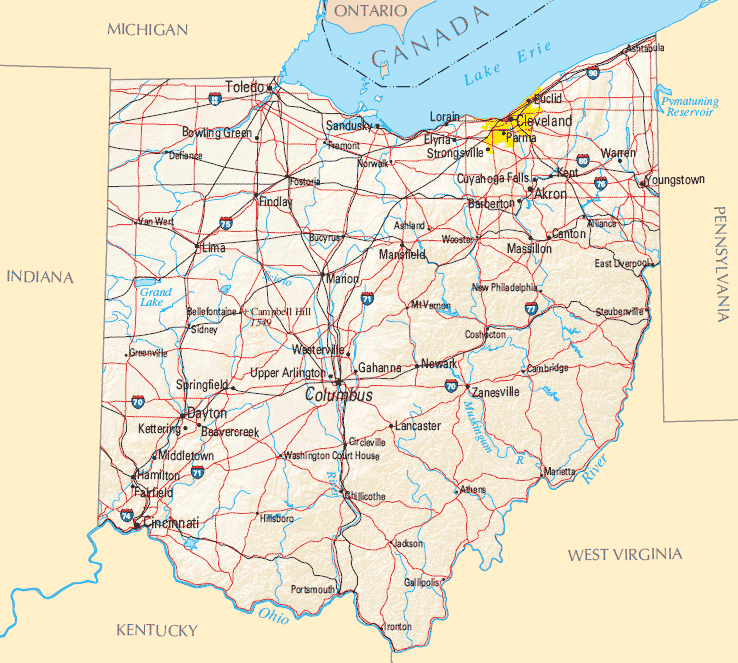
Ohio Map
N avigate Ohio Map, Ohio states map, satellite images of the Ohio, Ohio largest cities maps, political map of Ohio, driving directions and traffic maps.
All Ohio Cities Maps by Population
- Columbus Map - (787,033)
- Cleveland Map - (396,815)
- Cincinnati Map - (296,943)
- Toledo Map - (287,208)
- Akron Map - (199,110)
- Dayton Map - (141,527)
- Parma Map - (81,601)
- Canton Map - (73,007)
- Youngstown Map - (66,982)
- Lorain Map - (64,097)
- Hamilton Map - (62,477)
- Springfield Map - (60,608)
- Kettering Map - (56,163)
- Elyria Map - (54,533)
- Lakewood Map - (52,131)
- Cuyahoga Falls Map - (49,652)
- Euclid Map - (48,920)
- Middletown Map - (48,694)
- Mansfield Map - (47,821)
- Newark Map - (47,573)
- Mentor Map - (47,159)
- Cleveland Heights Map - (46,121)
- Beavercreek Map - (45,193)
- Strongsville Map - (44,750)
- Fairfield Map - (42,510)
- Dublin Map - (41,751)
- Warren Map - (41,557)
- Findlay Map - (41,202)
- Lancaster Map - (38,780)
- Lima Map - (38,771)
- Huber Heights Map - (38,101)
- Marion Map - (36,837)
- Westerville Map - (36,120)
- Reynoldsburg Map - (35,893)
- Grove City Map - (35,575)
- Boardman Map - (35,376)
- Stow Map - (34,837)
- Delaware Map - (34,753)
- Brunswick Map - (34,255)
- Upper Arlington Map - (33,771)
- Gahanna Map - (33,248)
- Westlake Map - (32,729)
- North Olmsted Map - (32,718)
- Fairborn Map - (32,352)
- Massillon Map - (32,149)
- Mason Map - (30,712)
- North Royalton Map - (30,444)
- Bowling Green Map - (30,028)
- Austintown Map - (29,677)
- North Ridgeville Map - (29,465)
- Kent Map - (28,904)
- Garfield Heights Map - (28,849)
- Shaker Heights Map - (28,448)
- Hilliard Map - (28,435)
- Medina Map - (26,678)
- Barberton Map - (26,550)
- Wooster Map - (26,119)
- Sandusky Map - (25,793)
- Xenia Map - (25,719)
- Green Map - (25,699)
- Zanesville Map - (25,487)
- Riverside Map - (25,201)
- Troy Map - (25,058)
- Trotwood Map - (24,431)
- Centerville Map - (23,999)
- Athens Map - (23,832)
- Solon Map - (23,348)
- Maple Heights Map - (23,138)
- Avon Lake Map - (22,581)
- Alliance Map - (22,322)
- South Euclid Map - (22,295)
- Willoughby Map - (22,268)
- Hudson Map - (22,262)
- Marysville Map - (22,094)
- Chillicothe Map - (21,901)
- Wadsworth Map - (21,567)
- Oxford Map - (21,371)
- Sidney Map - (21,229)
- Avon Map - (21,193)
- Parma Heights Map - (20,718)
- Perrysburg Map - (20,623)
- Piqua Map - (20,522)
- Ashland Map - (20,362)
- Oregon Map - (20,291)
- Portsmouth Map - (20,226)
- Rocky River Map - (20,213)
- Miamisburg Map - (20,181)
- Lebanon Map - (20,033)
- Painesville Map - (19,563)
- Broadview Heights Map - (19,400)
- Niles Map - (19,266)
- Brook Park Map - (19,212)
- Norwood Map - (19,207)
- White Oak Map - (19,167)
- Mayfield Heights Map - (19,155)
- Ashtabula Map - (19,124)
- Berea Map - (19,093)
- Sylvania Map - (18,965)
- Twinsburg Map - (18,795)
- Forest Park Map - (18,720)
- Steubenville Map - (18,659)
- Eastlake Map - (18,577)
- Pickerington Map - (18,291)
- Whitehall Map - (18,062)
- Tiffin Map - (17,963)
- East Cleveland Map - (17,843)
- Tallmadge Map - (17,537)
- North Canton Map - (17,488)
- Springboro Map - (17,409)
- New Philadelphia Map - (17,288)
- Norwalk Map - (17,012)
- Mount Vernon Map - (16,990)
- Fairview Park Map - (16,826)
- Fremont Map - (16,734)
- Defiance Map - (16,494)
- Streetsboro Map - (16,028)
- Middleburg Heights Map - (15,946)
- Bay Village Map - (15,651)
- Aurora Map - (15,548)
- Vandalia Map - (15,246)
- Pataskala Map - (14,962)
- Bridgetown Map - (14,407)
- Maumee Map - (14,286)
- New Franklin Map - (14,227)
- Washington Court House Map - (14,192)
- Willowick Map - (14,171)
- Marietta Map - (14,085)
- Lyndhurst Map - (14,001)
- Brecksville Map - (13,656)
- Worthington Map - (13,575)
- Sharonville Map - (13,560)
- Warrensville Heights Map - (13,542)
- University Heights Map - (13,539)
- Englewood Map - (13,465)
- Fostoria Map - (13,441)
- Bellefontaine Map - (13,370)
- Circleville Map - (13,314)
- Greenville Map - (13,227)
- Clayton Map - (13,209)
- West Carrollton Map - (13,143)
- Bedford Map - (13,074)
- Bexley Map - (13,057)
- Conneaut Map - (12,841)
- Dover Map - (12,826)
- Wickliffe Map - (12,750)
- Finneytown Map - (12,741)
- Wilmington Map - (12,520)
- Monroe Map - (12,442)
- Bucyrus Map - (12,362)
- Salem Map - (12,303)
- Blue Ash Map - (12,114)
- Norton Map - (12,085)
- Loveland Map - (12,081)
- Amherst Map - (12,021)
- Beachwood Map - (11,953)
- Monfort Heights Map - (11,948)
- Trenton Map - (11,869)
- Seven Hills Map - (11,804)
- Urbana Map - (11,793)
- Franklin Map - (11,771)
- Ravenna Map - (11,724)
- Mack Map - (11,585)
- Powell Map - (11,500)
- Springdale Map - (11,223)
- Coshocton Map - (11,216)
- East Liverpool Map - (11,195)
- Macedonia Map - (11,188)
- Brooklyn Map - (11,169)
- Ironton Map - (11,129)
- Van Wert Map - (10,846)
- Bedford Heights Map - (10,751)
- Struthers Map - (10,713)
- Northbrook Map - (10,668)
- Cambridge Map - (10,635)
- Vermilion Map - (10,594)
- Richmond Heights Map - (10,546)
- Forestville Map - (10,532)
- Galion Map - (10,512)
- Dent Map - (10,497)
- Celina Map - (10,400)
- Reading Map - (10,385)
- Heath Map - (10,310)
- Montgomery Map - (10,251)
- Girard Map - (9,958)
- London Map - (9,904)
- Harrison Map - (9,897)
- Wapakoneta Map - (9,867)
- Tipp City Map - (9,689)
- Willoughby Hills Map - (9,485)
- North College Hill Map - (9,397)
- Shelby Map - (9,317)
- Oakwood Map - (9,202)
- Beckett Ridge Map - (9,187)
- Louisville Map - (9,186)
- Sheffield Lake Map - (9,137)
- Lincoln Village Map - (9,032)
- Olmsted Falls Map - (9,024)
- Napoleon Map - (8,749)
- Madeira Map - (8,726)
- Blacklick Estates Map - (8,682)
- North Madison Map - (8,547)
- Bryan Map - (8,545)
- Perry Heights Map - (8,441)
- Wyoming Map - (8,428)
- Eaton Map - (8,407)
- Orrville Map - (8,380)
- Cheviot Map - (8,375)
- Highland Heights Map - (8,345)
- St. Marys Map - (8,332)
- Oberlin Map - (8,286)
- Kenton Map - (8,262)
- Campbell Map - (8,235)
- Bellevue Map - (8,202)
- Hubbard Map - (7,874)
- New Albany Map - (7,724)
- Northridge Map - (7,572)
- Canfield Map - (7,515)
- Mentor on the Lake Map - (7,443)
- Fairlawn Map - (7,437)
- Northgate Map - (7,377)
- Wauseon Map - (7,332)
- Dry Run Map - (7,281)
- Logan Map - (7,152)
- Huron Map - (7,149)
- Independence Map - (7,133)
- Cortland Map - (7,104)
- Delphos Map - (7,101)
- Canal Winchester Map - (7,101)
- Withamsville Map - (7,021)
- Kenwood Map - (6,981)
- Portage Lakes Map - (6,968)
- Bellbrook Map - (6,943)
- Martins Ferry Map - (6,915)
- Kirtland Map - (6,866)
- Groesbeck Map - (6,788)
- Landen Map - (6,782)
- Milford Map - (6,709)
- Grafton Map - (6,636)
- Hillsboro Map - (6,605)
- Upper Sandusky Map - (6,596)
- Grandview Heights Map - (6,536)
- Champion Heights Map - (6,498)
- Rittman Map - (6,491)
- Covedale Map - (6,447)
- Belpre Map - (6,441)
- Wheelersburg Map - (6,437)
- Union Map - (6,419)
- Jackson Map - (6,397)
- Columbiana Map - (6,384)
- Howland Center Map - (6,351)
- Clyde Map - (6,325)
- Moraine Map - (6,307)
- Rossford Map - (6,293)
- Willard Map - (6,236)
- Ontario Map - (6,225)
- Geneva Map - (6,215)
- Mount Healthy Map - (6,098)
- Port Clinton Map - (6,056)
- Pepper Pike Map - (5,979)
- Ada Map - (5,952)
- Brookville Map - (5,884)
- The Village of Indian Hill Map - (5,785)
- New Carlisle Map - (5,785)
- Deer Park Map - (5,736)
- Wellston Map - (5,663)
- Granville Map - (5,646)
- Germantown Map - (5,547)
- Waterville Map - (5,523)
- Canal Fulton Map - (5,479)
- Uhrichsville Map - (5,413)
- Nelsonville Map - (5,392)
- Groveport Map - (5,363)
- Northwood Map - (5,265)
- Delhi Hills Map - (5,259)
- St. Clairsville Map - (5,184)
- Montrose Ghent Map - (5,177)
- Chardon Map - (5,148)
- Turpin Hills Map - (5,099)
- Toronto Map - (5,091)
- Summerside Map - (5,083)
- New Burlington Map - (5,069)
- Apple Valley Map - (5,058)
- Munroe Falls Map - (5,012)
- Pleasant Run Map - (4,953)
- Carlisle Map - (4,915)
- Lexington Map - (4,822)
- Wellington Map - (4,802)
- Amelia Map - (4,801)
- Newton Falls Map - (4,795)
- Silverton Map - (4,788)
- Mount Carmel Map - (4,741)
- Miami Heights Map - (4,731)
- New Lexington Map - (4,731)
- East Palestine Map - (4,721)
- Mount Repose Map - (4,672)
- Pleasant Run Farm Map - (4,654)
- Greenfield Map - (4,639)
- Johnstown Map - (4,632)
- Crestline Map - (4,630)
- West Milton Map - (4,630)
- Huber Ridge Map - (4,604)
- Lake Darby Map - (4,592)
- Obetz Map - (4,532)
- Ottawa Hills Map - (4,517)
- Ottawa Map - (4,460)
- Edgewood Map - (4,432)
- Coldwater Map - (4,427)
- Sebring Map - (4,420)
- Waverly City Map - (4,408)
- Sunbury Map - (4,389)
- Cherry Grove Map - (4,378)
- St. Bernard Map - (4,368)
- Archbold Map - (4,346)
- Park Layne Map - (4,343)
- Georgetown Map - (4,331)
- Bellaire Map - (4,278)
- Blanchester Map - (4,243)
- Plain City Map - (4,225)
- West Jefferson Map - (4,222)
- Barnesville Map - (4,193)
- Whitehouse Map - (4,149)
- Bluffton Map - (4,125)
- South Lebanon Map - (4,115)
- Chagrin Falls Map - (4,113)
- Ashville Map - (4,097)
- Montpelier Map - (4,072)
- Cedarville Map - (4,019)
- New Lebanon Map - (3,995)
- Sheffield Map - (3,982)
- South Point Map - (3,958)
- Wintersville Map - (3,924)
- Mineral Ridge Map - (3,892)
- Mogadore Map - (3,853)
- Salem Heights Map - (3,839)
- Newcomerstown Map - (3,822)
- South Russell Map - (3,810)
- Greentown Map - (3,804)
- Shadyside Map - (3,785)
- Fruit Hill Map - (3,755)
- Calcutta Map - (3,742)
- Fort Shawnee Map - (3,726)
- Minerva Map - (3,720)
- Sherwood Map - (3,719)
- Swanton Map - (3,690)
- Northfield Map - (3,677)
- Carey Map - (3,674)
- Oakwood Map - (3,667)
- Mount Orab Map - (3,664)
- Mount Gilead Map - (3,660)
- Richfield Map - (3,648)
- Gallipolis Map - (3,641)
- Greenhills Map - (3,615)
- Golf Manor Map - (3,611)
- Paulding Map - (3,605)
- Amberley Map - (3,585)
- Hicksville Map - (3,581)
- Wellsville Map - (3,541)
- Yellow Springs Map - (3,487)
- Dillonvale Map - (3,474)
- Mayfield Map - (3,460)
- Mingo Junction Map - (3,454)
- Lockland Map - (3,449)
- North Baltimore Map - (3,432)
- Lordstown Map - (3,417)
- Ross Map - (3,417)
- Reminderville Map - (3,404)
- Mariemont Map - (3,403)
- Lake Lakengren Map - (3,383)
- Cadiz Map - (3,353)
- Brimfield Map - (3,343)
- Richville Map - (3,324)
- Orange Map - (3,323)
- Mulberry Map - (3,323)
- Moreland Hills Map - (3,320)
- Uniontown Map - (3,309)
- Woodlawn Map - (3,294)
- Lincoln Heights Map - (3,286)
- Bainbridge Map - (3,267)
- Mount Healthy Heights Map - (3,264)
- McDonald Map - (3,263)
- West Union Map - (3,241)
- Carrollton Map - (3,241)
- Cleves Map - (3,234)
- Madison Map - (3,184)
- Delshire Map - (3,180)
- West Portsmouth Map - (3,149)
- Jefferson Map - (3,120)
- Fairport Harbor Map - (3,109)
- Delta Map - (3,103)
- The Plains Map - (3,080)
- Lakemore Map - (3,068)
- Taylor Creek Map - (3,062)
- Doylestown Map - (3,051)
- Millersburg Map - (3,025)
- Beechwood Trails Map - (3,020)
- Walbridge Map - (3,019)
- New Bremen Map - (2,978)
- Ballville Map - (2,976)
- Baltimore Map - (2,966)
- Hartville Map - (2,944)
- Sixteen Mile Stand Map - (2,928)
- North Kingsville Map - (2,923)
- Four Bridges Map - (2,919)
- Waynesville Map - (2,834)
- Lisbon Map - (2,821)
- North Zanesville Map - (2,816)
- Minster Map - (2,805)
- Dry Ridge Map - (2,782)
- Evendale Map - (2,767)
- Oak Harbor Map - (2,759)
- Lucasville Map - (2,757)
- Buckeye Lake Map - (2,746)
- Lodi Map - (2,746)
- Bethel Map - (2,711)
- Middlefield Map - (2,694)
- Versailles Map - (2,687)
- Burlington Map - (2,676)
- Newtown Map - (2,672)
- Dennison Map - (2,655)
- Devola Map - (2,652)
- Loudonville Map - (2,641)
- Day Heights Map - (2,620)
- Strasburg Map - (2,608)
- Covington Map - (2,584)
- New Richmond Map - (2,582)
- Gibsonburg Map - (2,581)
- Sabina Map - (2,564)
- Poland Map - (2,555)
- Crooksville Map - (2,534)
- Middleport Map - (2,530)
- Chesterland Map - (2,521)
- Silver Lake Map - (2,519)
- Fredericktown Map - (2,493)
- New Concord Map - (2,491)
- Williamsburg Map - (2,490)
- New London Map - (2,461)
- Byesville Map - (2,438)
- St. Henry Map - (2,427)
- Enon Map - (2,415)
- Gambier Map - (2,391)
- Woodsfield Map - (2,384)
- Genoa Map - (2,336)
- Hebron Map - (2,336)
- Green Meadows Map - (2,327)
- Garrettsville Map - (2,325)
- West Lafayette Map - (2,321)
- Seville Map - (2,296)
- Walton Hills Map - (2,281)
- West Hill Map - (2,273)
- New Boston Map - (2,272)
- Wilberforce Map - (2,271)
- Gates Mills Map - (2,270)
- Terrace Park Map - (2,251)
- New Miami Map - (2,249)
- Rossmoyne Map - (2,230)
- Richwood Map - (2,229)
- Spencerville Map - (2,223)
- Sugarcreek Map - (2,220)
- Windham Map - (2,209)
- Elmwood Place Map - (2,188)
- Piketon Map - (2,181)
- Shawnee Hills Map - (2,171)
- Creston Map - (2,171)
- Newburgh Heights Map - (2,167)
- Coal Grove Map - (2,165)
- Glendale Map - (2,155)
- Churchill Map - (2,149)
- Columbus Grove Map - (2,137)
- Woodville Map - (2,135)
- Utica Map - (2,132)
- Arcanum Map - (2,129)
- Brewster Map - (2,112)
- Rosemount Map - (2,112)
- Lagrange Map - (2,103)
- Hunter Map - (2,100)
- Leipsic Map - (2,093)
- Bolindale Map - (2,089)
- St. Paris Map - (2,089)
- Drexel Map - (2,076)
- Masury Map - (2,064)
- Cardington Map - (2,047)
- Camden Map - (2,046)
- Valley View Map - (2,034)
- Manchester Map - (2,023)
- Edgerton Map - (2,012)
- Jamestown Map - (1,993)
- South Zanesville Map - (1,989)
- Glenmoor Map - (1,987)
- Leavittsburg Map - (1,973)
- Leetonia Map - (1,959)
- Navarre Map - (1,957)
- Bellville Map - (1,918)
- Elida Map - (1,905)
- Plymouth Map - (1,857)
- Cridersville Map - (1,852)
- Roseville Map - (1,852)
- Pomeroy Map - (1,852)
- Bradford Map - (1,842)
- Bridgeport Map - (1,831)
- Dalton Map - (1,830)
- Five Points Map - (1,824)
- Wright Patterson AFB Map - (1,821)
- Lewisburg Map - (1,820)
- West Liberty Map - (1,805)
- Deshler Map - (1,799)
- Glouster Map - (1,791)
- McConnelsville Map - (1,784)
- Mount Sterling Map - (1,782)
- Peebles Map - (1,782)
- Centerburg Map - (1,773)
- Holland Map - (1,764)
- Ripley Map - (1,750)
- Caldwell Map - (1,748)
- South Bloomfield Map - (1,744)
- Pleasant Grove Map - (1,742)
- Antwerp Map - (1,736)
- Dunlap Map - (1,719)
- Skyline Acres Map - (1,717)
- McArthur Map - (1,701)
- Fairfax Map - (1,699)
- South Charleston Map - (1,693)
- South Amherst Map - (1,688)
- West Unity Map - (1,671)
- Union City Map - (1,666)
- Perry Map - (1,663)
- Orwell Map - (1,660)
- Franklin Furnace Map - (1,660)
- Lake Mohawk Map - (1,652)
- McComb Map - (1,648)
- Mechanicsburg Map - (1,644)
- Aberdeen Map - (1,638)
- New Paris Map - (1,629)
- New Middletown Map - (1,621)
- Powhatan Point Map - (1,592)
- East Canton Map - (1,591)
- Weston Map - (1,590)
- Commercial Point Map - (1,582)
- Anna Map - (1,567)
- Oak Hill Map - (1,551)
- Choctaw Lake Map - (1,546)
- Brooklyn Heights Map - (1,543)
- Kalida Map - (1,542)
- Sawyerwood Map - (1,540)
- Dresden Map - (1,529)
- Curtice Map - (1,526)
- Loveland Park Map - (1,523)
- Shreve Map - (1,514)
- Holiday Valley Map - (1,510)
- Harbor Hills Map - (1,509)
- Batavia Map - (1,509)
- Roaming Shores Map - (1,508)
- Highpoint Map - (1,503)
- Lynchburg Map - (1,499)
- North Lewisburg Map - (1,490)
- Crystal Lakes Map - (1,483)
- Brilliant Map - (1,482)
- Somerset Map - (1,481)
- Fort Loramie Map - (1,478)
- Greenwich Map - (1,476)
- Grandview Map - (1,466)
- West Salem Map - (1,464)
- Jackson Center Map - (1,462)
- Forest Map - (1,461)
- Arlington Map - (1,455)
- Burton Map - (1,455)
- Fort Recovery Map - (1,430)
- Bremen Map - (1,425)
- New California Map - (1,411)
- Granville South Map - (1,410)
- Elmore Map - (1,410)
- Hiram Map - (1,406)
- Monroeville Map - (1,400)
- Pheasant Run Map - (1,397)
- Russells Point Map - (1,391)
- Pioneer Map - (1,380)
- Tiltonsville Map - (1,372)
- Pemberville Map - (1,371)
- Green Springs Map - (1,368)
- Milan Map - (1,367)
- West Alexandria Map - (1,340)
- Stryker Map - (1,335)
- Ashley Map - (1,330)
- Frazeysburg Map - (1,326)
- Kings Mills Map - (1,319)
- Leesburg Map - (1,314)
- Beverly Map - (1,313)
- Salineville Map - (1,311)
- Wetherington Map - (1,302)
- Boston Heights Map - (1,300)
- Reno Map - (1,293)
- Fairfield Beach Map - (1,292)
- Geneva on the Lake Map - (1,288)
- Gnadenhutten Map - (1,288)
- De Graff Map - (1,285)
- Stony Prairie Map - (1,284)
- Fayette Map - (1,283)
- Minerva Park Map - (1,272)
- Miamitown Map - (1,259)
- Bethesda Map - (1,256)
- Smithville Map - (1,252)
- Cinnamon Lake Map - (1,243)
- Wolfhurst Map - (1,239)
- New Waterford Map - (1,238)
- Morgandale Map - (1,224)
- New Vienna Map - (1,224)
- Eaton Estates Map - (1,222)
- Etna Map - (1,215)
- Clinton Map - (1,214)
- Brookfield Center Map - (1,207)
- Jeffersonville Map - (1,203)
- Pleasant Hill Map - (1,200)
- Millbury Map - (1,200)
- Bratenahl Map - (1,197)
- Payne Map - (1,194)
- Malvern Map - (1,189)
- Morrow Map - (1,188)
- Haskins Map - (1,188)
- Craig Beach Map - (1,180)
- Liberty Center Map - (1,180)
- Ansonia Map - (1,174)
- Coldstream Map - (1,173)
- Lake Waynoka Map - (1,173)
- Apple Creek Map - (1,173)
- Lake Lorelei Map - (1,170)
- Lowellville Map - (1,155)
- Botkins Map - (1,155)
- Pandora Map - (1,153)
- Continental Map - (1,153)
- Candlewood Lake Map - (1,147)
- Andover Map - (1,145)
- La Croft Map - (1,144)
- Highland Hills Map - (1,130)
- Rockford Map - (1,120)
- Logan Elm Village Map - (1,118)
- Westfield Center Map - (1,115)
- Prospect Map - (1,112)
- Holgate Map - (1,109)
- Lithopolis Map - (1,106)
- South Canal Map - (1,100)
- Convoy Map - (1,085)
- Sciotodale Map - (1,081)
- Yorkville Map - (1,079)
- Lakeview Map - (1,072)
- Frankfort Map - (1,064)
- McKinley Heights Map - (1,060)
- Tuscarawas Map - (1,056)
- Winchester Map - (1,051)
- Chauncey Map - (1,049)
- Wakeman Map - (1,047)
- Danville Map - (1,044)
- Millersport Map - (1,044)
- Mantua Map - (1,043)
- Beach City Map - (1,033)
- Kingston Map - (1,032)
- North Randall Map - (1,027)
- Williamsport Map - (1,023)
- Luckey Map - (1,012)
- Farmersville Map - (1,009)
- Thornport Map - (1,004)
- Newport Map - (1,003)
- Glandorf Map - (1,001)
- Bolivar Map - (994)
- Neffs Map - (993)
- Thornville Map - (991)
- Bradner Map - (985)
- Sardinia Map - (980)
- Magnolia Map - (978)
- Beloit Map - (978)
- Ottoville Map - (976)
- Maineville Map - (975)
- New Washington Map - (967)
- Grand Rapids Map - (965)
- Urbancrest Map - (960)
- Pleasantville Map - (960)
- Blue Jay Map - (959)
- Clarktown Map - (958)
- Bloomville Map - (956)
- Hopedale Map - (950)
- Seaman Map - (944)
- Kidron Map - (944)
- Bloomingburg Map - (938)
- Addyston Map - (938)
- Butler Map - (933)
- Twinsburg Heights Map - (925)
- Glenwillow Map - (923)
- Waynesburg Map - (923)
- Hanover Map - (921)
- Marblehead Map - (903)
- Attica Map - (899)
- Berlin Map - (898)
- Matamoras Map - (896)
- North Perry Map - (893)
- New Madison Map - (892)
- Chippewa Park Map - (891)
- Wayne Map - (887)
- Woodmere Map - (884)
- Pigeon Creek Map - (882)
- Gratis Map - (881)
- Duncan Falls Map - (880)
- New Knoxville Map - (879)
- Hamden Map - (879)
- Flushing Map - (879)
- Walnut Creek Map - (878)
- Dunkirk Map - (875)
- Smithfield Map - (869)
- South Webster Map - (866)
- Bentleyville Map - (864)
- Sycamore Map - (861)
- Alger Map - (860)
- Bainbridge Map - (860)
- North Bend Map - (857)
- Castalia Map - (852)
- Waynesfield Map - (847)
- Edon Map - (834)
- Rio Grande Map - (830)
- Albany Map - (828)
- Sherwood Map - (827)
- Syracuse Map - (826)
- East Sparta Map - (819)
- Junction City Map - (819)
- Felicity Map - (818)
- Killbuck Map - (817)
- Belle Center Map - (813)
- Washingtonville Map - (801)
- New Holland Map - (801)
- Baltic Map - (795)
- Hide A Way Hills Map - (794)
- Owensville Map - (794)
- Darbydale Map - (793)
- Milford Center Map - (792)
- Marne Map - (783)
- Andersonville Map - (779)
- Scio Map - (763)
- Maple Ridge Map - (761)
- Nevada Map - (760)
- Adena Map - (759)
- Atwater Map - (758)
- Marshallville Map - (756)
- Midvale Map - (754)
- Spencer Map - (753)
- Seven Mile Map - (751)
- Holiday Lakes Map - (749)
- La Rue Map - (747)
- Chesapeake Map - (745)
- Arlington Heights Map - (745)
- Amanda Map - (737)
- Perrysville Map - (735)
- Philo Map - (733)
- Mineral City Map - (727)
- McClure Map - (725)
- Shawnee Map - (724)
- New Straitsville Map - (722)
- Wayne Lakes Map - (718)
- Berlin Heights Map - (714)
- Chippewa Lake Map - (711)
- Millville Map - (708)
- Quincy Map - (706)
- Ohio City Map - (705)
- Hunting Valley Map - (705)
- Lakeside Map - (694)
- Minford Map - (693)
- Jewett Map - (692)
- Warsaw Map - (682)
- West Mansfield Map - (682)
- Shawnee Hills Map - (681)
- Bloomdale Map - (678)
- Racine Map - (675)
- Timberlake Map - (675)
- Malta Map - (671)
- Dillonvale Map - (665)
- Bergholz Map - (664)
- Concorde Hills Map - (663)
- Mendon Map - (662)
- New Baltimore Map - (661)
- Bettsville Map - (661)
- Shawnee Map - (655)
- Galena Map - (653)
- Vienna Center Map - (650)
- Shiloh Map - (649)
- Kirtland Hills Map - (646)
- Ostrander Map - (643)
- Russia Map - (640)
- Rocky Fork Point Map - (639)
- Cuyahoga Heights Map - (638)
- Lansing Map - (634)
- Brookside Map - (632)
- Bay View Map - (632)
- Collins Map - (631)
- Mount Victory Map - (627)
- Metamora Map - (627)
- Valleyview Map - (620)
- Kinsman Center Map - (616)
- Lucas Map - (615)
- Oakwood Map - (608)
- Pleasant Hills Map - (606)
- Risingsun Map - (606)
- Thurston Map - (604)
- Lake Buckhorn Map - (601)
- Cygnet Map - (597)
- Arcadia Map - (590)
- Corning Map - (583)
- New Haven Map - (583)
- Williamsdale Map - (581)
- Caledonia Map - (577)
- Hamler Map - (576)
- Middle Point Map - (576)
- Proctorville Map - (574)
- Marble Cliff Map - (573)
- Rawson Map - (570)
- Meyers Lake Map - (569)
- Port Washington Map - (569)
- Peninsula Map - (565)
- Jeromesville Map - (562)
- Lyons Map - (562)
- Russellville Map - (561)
- North Fairfield Map - (560)
- Stoutsville Map - (560)
- Sardis Map - (559)
- Buchtel Map - (558)
- Phillipsburg Map - (557)
- Highland Holiday Map - (550)
- Lowell Map - (549)
- Republic Map - (549)
- Clarksville Map - (548)
- Hamersville Map - (546)
- Harveysburg Map - (546)
- Riverlea Map - (545)
- Hooven Map - (534)
- Hilltop Map - (532)
- Rock Creek Map - (529)
- Laurelville Map - (527)
- Christiansburg Map - (526)
- Kirkersville Map - (525)
- Cairo Map - (524)
- Carroll Map - (524)
- Alexandria Map - (517)
- Rushsylvania Map - (516)
- Darrtown Map - (516)
- Austinburg Map - (516)
- New Bloomington Map - (515)
- Gettysburg Map - (513)
- Amsterdam Map - (511)
- Eldorado Map - (509)
- Stockport Map - (503)
- Quaker City Map - (502)
- McGuffey Map - (501)
- West Farmington Map - (499)
- Pettisville Map - (498)
- Coolville Map - (496)
- Verona Map - (494)
- Mount Blanchard Map - (492)
- Williston Map - (487)
- Fort Jennings Map - (485)
- Lake Tomahawk Map - (485)
- Richmond Map - (481)
- Jacksonville Map - (481)
- Homeworth Map - (481)
- Spring Valley Map - (479)
- Coalton Map - (479)
- North Hampton Map - (478)
- Mount Pleasant Map - (478)
- West Manchester Map - (474)
- Laura Map - (474)
- Fletcher Map - (473)
- Waite Hill Map - (471)
- Tuppers Plains Map - (465)
- Lake Seneca Map - (465)
- Brady Lake Map - (464)
- Martinsville Map - (463)
- Rudolph Map - (458)
- Sterling Map - (457)
- Senecaville Map - (457)
- Clarksburg Map - (455)
- Belmont Map - (453)
- Iberia Map - (452)
- Waterford Map - (450)
- Beaver Map - (449)
- Murray City Map - (449)
- Hayesville Map - (448)
- Pleasant City Map - (447)
- Lindsey Map - (446)
- Lafayette Map - (445)
- Damascus Map - (443)
- Portage Map - (438)
- Edison Map - (437)
- Ridgeville Corners Map - (435)
- McDermott Map - (434)
- Huntsville Map - (431)
- Jerry City Map - (427)
- Sugar Grove Map - (426)
- Gloria Glens Park Map - (425)
- Neapolis Map - (423)
- Fredericksburg Map - (423)
- Corwin Map - (421)
- Rocky Ridge Map - (417)
- Rayland Map - (417)
- Harrod Map - (417)
- Savannah Map - (413)
- Crown City Map - (413)
- Hannibal Map - (411)
- Stony Ridge Map - (411)
- Beallsville Map - (409)
- Hanoverton Map - (408)
- Derby Map - (408)
- College Corner Map - (407)
- Grover Hill Map - (402)
- Buffalo Map - (401)
- McCutchenville Map - (400)
- Morral Map - (399)
- New Haven Map - (399)
- Grand River Map - (399)
- Bowerston Map - (398)
- Hartford Map - (397)
- Willshire Map - (397)
- Barnhill Map - (396)
- Rutland Map - (393)
- Newtonsville Map - (392)
- Bascom Map - (390)
- Trimble Map - (390)
- Pitsburg Map - (388)
- New Pittsburg Map - (388)
- Irondale Map - (387)
- Clarington Map - (384)
- South Vienna Map - (384)
- Beaverdam Map - (382)
- Haydenville Map - (381)
- Adelphi Map - (380)
- Richmond Dale Map - (377)
- Whites Landing Map - (375)
- Camp Dennison Map - (375)
- Tremont City Map - (375)
- Green Camp Map - (374)
- St. Louisville Map - (373)
- Athalia Map - (373)
- Holmesville Map - (372)
- Bailey Lakes Map - (371)
- Port Jefferson Map - (371)
- Freeport Map - (369)
- Sandyville Map - (368)
- Tontogany Map - (367)
- Cumberland Map - (367)
- East Liberty Map - (366)
- Trinway Map - (365)
- Mowrystown Map - (360)
- Vanlue Map - (359)
- Wharton Map - (358)
- Dellroy Map - (356)
- South Solon Map - (355)
- Ney Map - (354)
- Buford Map - (352)
- Winesburg Map - (352)
- Friendship Map - (351)
- Elizabethtown Map - (350)
- Conesville Map - (347)
- Marengo Map - (342)
- Millfield Map - (341)
- Aquilla Map - (340)
- Vincent Map - (339)
- Holloway Map - (338)
- Waldo Map - (338)
- Ridgeway Map - (338)
- Polk Map - (336)
- East Fultonham Map - (335)
- Robertsville Map - (331)
- Fayetteville Map - (330)
- Remington Map - (328)
- Van Buren Map - (328)
- New Marshfield Map - (326)
- Lore City Map - (325)
- Midway Map - (322)
- Canal Lewisville Map - (320)
- New Athens Map - (320)
- Harrisburg Map - (320)
- Plumwood Map - (319)
- Dupont Map - (318)
- Midland Map - (315)
- Bowersville Map - (312)
- Kelleys Island Map - (312)
- Glencoe Map - (310)
- Woodstock Map - (305)
- Lafferty Map - (304)
- Wilmot Map - (304)
- Sherrodsville Map - (304)
- Donnelsville Map - (304)
- Hoytville Map - (303)
- Morristown Map - (303)
- Rushville Map - (302)
- Osgood Map - (302)
- Empire Map - (299)
- Benton Ridge Map - (299)
- Dundee Map - (297)
- Stratton Map - (294)
- Pottery Addition Map - (293)
- Chickasaw Map - (290)
- Chesterhill Map - (289)
- Potsdam Map - (288)
- Bentonville Map - (287)
- Scott Map - (286)
- Tarlton Map - (282)
- Negley Map - (281)
- Somerville Map - (281)
- Maplewood Park Map - (280)
- Tiro Map - (280)
- Old Washington Map - (279)
- Zaleski Map - (278)
- Clay Center Map - (276)
- Melrose Map - (275)
- Catawba Map - (272)
- New Alexandria Map - (272)
- Glenmont Map - (272)
- Orient Map - (270)
- Magnetic Springs Map - (268)
- North Lawrence Map - (268)
- Casstown Map - (267)
- Malinta Map - (265)
- Little Hocking Map - (263)
- Vaughnsville Map - (262)
- Fulton Map - (258)
- Raymond Map - (257)
- Rosewood Map - (257)
- Highland Map - (254)
- Summerfield Map - (254)
- Port William Map - (254)
- Fort Seneca Map - (254)
- Higginsport Map - (251)
- New Riegel Map - (249)
- Stewart Map - (247)
- Kunkle Map - (246)
- Brecon Map - (244)
- Burkettsville Map - (244)
- Kipton Map - (243)
- Miamiville Map - (242)
- Howard Map - (242)
- Mount Eaton Map - (241)
- Olde West Chester Map - (240)
- Berkey Map - (237)
- Lockbourne Map - (237)
- Martinsburg Map - (237)
- Rogers Map - (237)
- North Star Map - (236)
- Harrisville Map - (235)
- Good Hope Map - (234)
- Buckland Map - (233)
- Carbon Hill Map - (233)
- Flat Rock Map - (233)
- Unionville Center Map - (233)
- Florida Map - (232)
- East Rochester Map - (231)
- Chesterville Map - (228)
- Hollansburg Map - (227)
- Lakeline Map - (226)
- Helena Map - (224)
- Belle Valley Map - (223)
- Lewistown Map - (222)
- Darbyville Map - (222)
- Uniopolis Map - (222)
- Vinton Map - (222)
- Gratiot Map - (221)
- Jenera Map - (221)
- Hills and Dales Map - (221)
- Hanging Rock Map - (221)
- Brownsville Map - (220)
- Roswell Map - (219)
- Parral Map - (218)
- Alvordton Map - (217)
- Haviland Map - (215)
- Hessville Map - (214)
- Hockingport Map - (212)
- Gordon Map - (212)
- Valley Hi Map - (212)
- Bannock Map - (211)
- Celeryville Map - (210)
- Ludlow Falls Map - (208)
- Burbank Map - (207)
- West Leipsic Map - (206)
- North Robinson Map - (205)
- South Salem Map - (204)
- Mount Cory Map - (204)
- Harpster Map - (204)
- Lafayette Map - (202)
- Bloomingdale Map - (202)
- Radnor Map - (201)
- Rossburg Map - (201)
- Palestine Map - (200)
- Bourneville Map - (199)
- Newport Map - (198)
- Orangeville Map - (197)
- Zanesfield Map - (197)
- Nashville Map - (197)
- West Elkton Map - (197)
- Sulphur Springs Map - (194)
- Wren Map - (194)
- Latty Map - (193)
- Bladensburg Map - (191)
- Oceola Map - (190)
- Chatfield Map - (189)
- Cecil Map - (188)
- Macksburg Map - (186)
- Old Fort Map - (186)
- Moscow Map - (185)
- Congress Map - (185)
- St Johns Map - (185)
- Gilboa Map - (184)
- Rochester Map - (182)
- Rockbridge Map - (182)
- Kansas Map - (179)
- Custar Map - (179)
- Kettlersville Map - (179)
- Linndale Map - (179)
- Sugar Bush Knolls Map - (177)
- Stone Creek Map - (177)
- Fultonham Map - (176)
- Lewisville Map - (176)
- Crystal Rock Map - (176)
- Kanauga Map - (175)
- West Millgrove Map - (174)
- New Hampshire Map - (174)
- Glenford Map - (173)
- Tedrow Map - (173)
- Burgoon Map - (172)
- Zoar Map - (169)
- Cloverdale Map - (168)
- Sarahsville Map - (166)
- Montezuma Map - (165)
- Butlerville Map - (163)
- Jerusalem Map - (161)
- Sparta Map - (161)
- Rarden Map - (159)
- Leesville Map - (158)
- Plainfield Map - (157)
- Hemlock Map - (155)
- Cherry Fork Map - (155)
- Pleasant Plain Map - (154)
- Amesville Map - (154)
- Melmore Map - (153)
- Clifton Map - (152)
- Limaville Map - (151)
- Wilkesville Map - (149)
- Milton Center Map - (144)
- Kimbolton Map - (144)
- Belmore Map - (143)
- Lockington Map - (141)
- Dola Map - (140)
- Fresno Map - (140)
- Patterson Map - (139)
- Kilbourne Map - (139)
- Put in Bay Map - (138)
- Miller City Map - (137)
- Mifflin Map - (137)
- New Weston Map - (136)
- Ithaca Map - (136)
- Summitville Map - (135)
- Stockdale Map - (135)
- West Rushville Map - (134)
- Sinking Spring Map - (133)
- Pulaski Map - (132)
- Cheshire Map - (132)
- Nellie Map - (131)
- Castine Map - (130)
- Bairdstown Map - (130)
- Dexter City Map - (129)
- Salesville Map - (129)
- St. Martin Map - (129)
- Wilson Map - (125)
- Gann Map - (125)
- Venedocia Map - (124)
- Harbor View Map - (123)
- Vickery Map - (121)
- Tippecanoe Map - (121)
- Broughton Map - (120)
- Kirby Map - (118)
- Brice Map - (114)
- Adamsville Map - (114)
- Milledgeville Map - (112)
- Marseilles Map - (112)
- Mutual Map - (104)
- Centerville Map - (103)
- Norwich Map - (102)
- Neville Map - (100)
- New Bavaria Map - (99)
- Yorkshire Map - (96)
- Blakeslee Map - (96)
- Rome Map - (94)
- Pancoastburg Map - (87)
- Plainville Map - (87)
- Otway Map - (87)
- Antioch Map - (86)
- Lower Salem Map - (86)
- Fairview Map - (83)
- Stafford Map - (81)
- Deersville Map - (79)
- Yankee Lake Map - (79)
- Graysville Map - (76)
- Wightmans Grove Map - (72)
- Batesville Map - (71)
- Cynthiana Map - (68)
- Jacksonburg Map - (63)
- Chilo Map - (63)
- Octa Map - (59)
- Elgin Map - (57)
- Beulah Beach Map - (53)
- Holiday City Map - (52)
- Miltonsburg Map - (43)
- Rendville Map - (36)
Largest Ohio cities map
Ohio Google Map, Street Views, Maps Directions, Satellite Images
Please Not : You can find local businesses, public places, tourist attractions via map view, satellite image, hybrid view, driving directions in Ohio Map. You'll also find a varity map of Ohio such as political, administrative, transportation, demographics maps following Google map.
Submit URL to Ohio :
Click for Ohio Direction »
Click for Ohio Street View »
Largest Cities Map of Ohio and Population
Columbus Map - 787,033 Cleveland Map - 396,815 Cincinnati Map - 296,943 Toledo Map - 287,208 Akron Map - 199,110 Dayton Map - 141,527 Parma Map - 81,601 Canton Map - 73,007 Youngstown Map - 66,982 Lorain Map - 64,097 Hamilton Map - 62,477 Springfield Map - 60,608 Kettering Map - 56,163 Elyria Map - 54,533 Lakewood Map - 52,131 Cuyahoga Falls Map - 49,652 Euclid Map - 48,920 Middletown Map - 48,694 Mansfield Map - 47,821 Newark Map - 47,573Copyright Turkey Travel Guide - 2006 - 2023. All rights reserved. Privacy Policy | Disclaimer