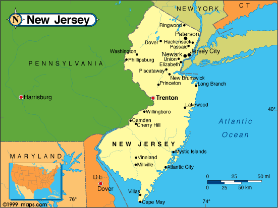
New Jersey Map
N avigate New Jersey Map, New Jersey states map, satellite images of the New Jersey, New Jersey largest cities maps, political map of New Jersey, driving directions and traffic maps.
All New Jersey Cities Maps by Population
- Newark Map - (277,140)
- Jersey City Map - (247,597)
- Paterson Map - (146,199)
- Elizabeth Map - (124,969)
- Edison Township Map - (99,967)
- Toms River Map - (88,791)
- Trenton Map - (84,913)
- Clifton Map - (84,136)
- Camden Map - (77,344)
- Passaic Map - (69,781)
- Union City Map - (66,455)
- East Orange Map - (64,270)
- Bayonne Map - (63,024)
- Vineland Map - (60,724)
- Union Township Map - (56,642)
- New Brunswick Map - (55,181)
- Wayne Township Map - (54,717)
- Irvington Township Map - (53,926)
- Lakewood Map - (53,805)
- Perth Amboy Map - (50,814)
- Hoboken Map - (50,005)
- Plainfield Map - (49,808)
- West New York Map - (49,708)
- East Brunswick Township Map - (47,512)
- Bloomfield Township Map - (47,315)
- West Orange Township Map - (46,207)
- Hackensack Map - (43,010)
- Sayreville Map - (42,704)
- North Brunswick Township Map - (40,742)
- Kearny Map - (40,684)
- Linden Map - (40,499)
- Teaneck Township Map - (39,776)
- Atlantic City Map - (39,558)
- Montclair Township Map - (37,669)
- Belleville Township Map - (35,926)
- Pennsauken Township Map - (35,885)
- Ewing Township Map - (35,790)
- Fort Lee Map - (35,345)
- Fair Lawn Map - (32,457)
- Long Branch Map - (30,719)
- Garfield Map - (30,487)
- Westfield Map - (30,316)
- City of Orange Township Map - (30,134)
- Livingston Township Map - (29,366)
- Millville Map - (28,400)
- Nutley Township Map - (28,370)
- Rahway Map - (27,346)
- Englewood Map - (27,147)
- Bergenfield Map - (26,764)
- Paramus Map - (26,342)
- West Milford Township Map - (25,850)
- Bridgeton Map - (25,349)
- Ridgewood Map - (24,958)
- Lodi Map - (24,136)
- Maplewood Township Map - (23,867)
- Old Bridge Map - (23,753)
- Cliffside Park Map - (23,594)
- Scotch Plains Township Map - (23,510)
- South Plainfield Map - (23,385)
- Carteret Map - (22,844)
- Cranford Township Map - (22,625)
- Somerset Map - (22,083)
- North Plainfield Map - (21,936)
- Summit Map - (21,457)
- Hillside Township Map - (21,404)
- Roselle Map - (21,085)
- Lyndhurst Township Map - (20,554)
- Pleasantville Map - (20,249)
- Millburn Township Map - (20,149)
- Palisades Park Map - (19,622)
- Elmwood Park Map - (19,403)
- Woodbridge Map - (19,265)
- Hawthorne Map - (18,791)
- Iselin Map - (18,695)
- Glassboro Map - (18,579)
- Morristown Map - (18,411)
- Point Pleasant Map - (18,392)
- Dover Map - (18,157)
- Rutherford Map - (18,061)
- Tinton Falls Map - (17,892)
- Colonia Map - (17,795)
- Lindenwold Map - (17,613)
- Dumont Map - (17,479)
- Avenel Map - (17,011)
- Wyckoff Township Map - (16,696)
- New Milford Map - (16,341)
- Secaucus Map - (16,264)
- South Orange Village Township Map - (16,198)
- Ocean Acres Map - (16,142)
- Asbury Park Map - (16,116)
- South River Map - (16,008)
- Madison Map - (15,845)
- Springfield Township Map - (15,817)
- Williamstown Map - (15,567)
- North Arlington Map - (15,392)
- Fords Map - (15,187)
- Hopatcong Map - (15,147)
- Phillipsburg Map - (14,950)
- Hammonton Map - (14,791)
- Clark Township Map - (14,756)
- Springdale Map - (14,518)
- Tenafly Map - (14,488)
- Ramsey Map - (14,473)
- Little Falls Township Map - (14,432)
- Moorestown Lenola Map - (14,217)
- Bradley Gardens Map - (14,206)
- Cherry Hill Mall Map - (14,171)
- Highland Park Map - (13,982)
- Collingswood Map - (13,926)
- Fairview Map - (13,835)
- Princeton Meadows Map - (13,834)
- Saddle Brook Township Map - (13,659)
- Middlesex Map - (13,635)
- Harrison Map - (13,620)
- West Freehold Map - (13,613)
- Metuchen Map - (13,574)
- Verona Township Map - (13,332)
- Roselle Park Map - (13,297)
- Franklin Park Map - (13,295)
- Mercerville Map - (13,230)
- Berkeley Heights Township Map - (13,183)
- Short Hills Map - (13,165)
- Holiday City Berkeley Map - (12,831)
- Hamilton Square Map - (12,784)
- Oakland Map - (12,754)
- Ridgefield Park Map - (12,729)
- Eatontown Map - (12,709)
- Cedar Grove Township Map - (12,411)
- Princeton Map - (12,307)
- Ringwood Map - (12,228)
- Red Bank Map - (12,206)
- New Providence Map - (12,171)
- Somerville Map - (12,098)
- Freehold Map - (12,052)
- Martinsville Map - (11,980)
- Pennsville Map - (11,888)
- Hasbrouck Heights Map - (11,842)
- Woodland Park Map - (11,819)
- Ocean City Map - (11,701)
- Florham Park Map - (11,696)
- Glen Rock Map - (11,601)
- Haddonfield Map - (11,593)
- Bellmawr Map - (11,583)
- Upper Montclair Map - (11,565)
- Edgewater Map - (11,513)
- Gloucester City Map - (11,456)
- Greentree Map - (11,367)
- River Edge Map - (11,340)
- Wallington Map - (11,335)
- Robertsville Map - (11,297)
- Browns Mills Map - (11,223)
- Guttenberg Map - (11,176)
- Wanaque Map - (11,116)
- Pompton Lakes Map - (11,097)
- Beachwood Map - (11,045)
- Ridgefield Map - (11,032)
- Westwood Map - (10,908)
- Totowa Map - (10,804)
- Somers Point Map - (10,795)
- West Caldwell Township Map - (10,759)
- Echelon Map - (10,743)
- Ventnor City Map - (10,650)
- Little Ferry Map - (10,626)
- Franklin Lakes Map - (10,590)
- Lincoln Park Map - (10,521)
- Bound Brook Map - (10,402)
- Manville Map - (10,344)
- Kinnelon Map - (10,248)
- Pine Hill Map - (10,233)
- Hillsdale Map - (10,219)
- Woodbury Map - (10,174)
- Marlton Map - (10,133)
- Keansburg Map - (10,105)
- Burlington Map - (9,920)
- Lake Mohawk Map - (9,916)
- Hackettstown Map - (9,724)
- River Vale Township Map - (9,659)
- Waldwick Map - (9,625)
- Maywood Map - (9,555)
- White Horse Map - (9,494)
- Villas Map - (9,483)
- Brigantine Map - (9,450)
- Kendall Park Map - (9,339)
- Brookdale Map - (9,239)
- Succasunna Map - (9,152)
- Washington Township Map - (9,102)
- Pitman Map - (9,011)
- Budd Lake Map - (8,968)
- Chatham Map - (8,962)
- Leonia Map - (8,937)
- East Rutherford Map - (8,913)
- White Meadow Lake Map - (8,836)
- Audubon Map - (8,819)
- Matawan Map - (8,810)
- Pine Lake Park Map - (8,707)
- East Franklin Map - (8,669)
- Park Ridge Map - (8,645)
- South Amboy Map - (8,631)
- Northfield Map - (8,624)
- Cresskill Map - (8,573)
- Mystic Island Map - (8,493)
- Runnemede Map - (8,468)
- North Haledon Map - (8,417)
- Absecon Map - (8,411)
- Closter Map - (8,373)
- Boonton Map - (8,347)
- Haledon Map - (8,318)
- Ashland Map - (8,302)
- Spotswood Map - (8,257)
- Upper Saddle River Map - (8,208)
- Bogota Map - (8,187)
- Clayton Map - (8,179)
- West Long Branch Map - (8,097)
- Newton Map - (7,997)
- Oradell Map - (7,978)
- Kenilworth Map - (7,914)
- Crestwood Village Map - (7,907)
- Montvale Map - (7,844)
- Caldwell Map - (7,822)
- Fort Dix Map - (7,716)
- Bernardsville Map - (7,707)
- Bloomingdale Map - (7,656)
- Wood Ridge Map - (7,626)
- Berlin Map - (7,588)
- Butler Map - (7,539)
- Glen Ridge Map - (7,527)
- Haddon Heights Map - (7,473)
- Fairfield Township Map - (7,466)
- Twin Rivers Map - (7,443)
- Emerson Map - (7,401)
- Palmyra Map - (7,398)
- Carneys Point Map - (7,382)
- Fanwood Map - (7,318)
- Strathmore Map - (7,258)
- Smithville Map - (7,242)
- Keyport Map - (7,240)
- Dunellen Map - (7,227)
- Yardville Map - (7,186)
- Madison Park Map - (7,144)
- Midland Park Map - (7,128)
- Pomona Map - (7,124)
- Rumson Map - (7,122)
- Linwood Map - (7,092)
- Dayton Map - (7,063)
- Stratford Map - (7,040)
- Barrington Map - (6,983)
- Milltown Map - (6,893)
- Raritan Map - (6,881)
- Mountainside Map - (6,685)
- Laurence Harbor Map - (6,536)
- Yorketown Map - (6,535)
- Wharton Map - (6,522)
- Allendale Map - (6,505)
- Washington Map - (6,461)
- Rockaway Map - (6,438)
- Margate City Map - (6,354)
- Union Beach Map - (6,245)
- Ramtown Map - (6,242)
- Green Knoll Map - (6,200)
- North Caldwell Map - (6,183)
- Lincroft Map - (6,135)
- Carlstadt Map - (6,127)
- Fair Haven Map - (6,121)
- Paulsboro Map - (6,097)
- Little Silver Map - (5,950)
- Jamesburg Map - (5,915)
- Ramblewood Map - (5,907)
- Manasquan Map - (5,897)
- Prospect Park Map - (5,865)
- Oceanport Map - (5,832)
- Heathcote Map - (5,821)
- Roseland Map - (5,819)
- Watchung Map - (5,801)
- Belmar Map - (5,794)
- Old Tappan Map - (5,750)
- Woodcliff Lake Map - (5,730)
- Norwood Map - (5,711)
- Kingston Estates Map - (5,685)
- Finderne Map - (5,600)
- Morris Plains Map - (5,532)
- Rochelle Park Township Map - (5,530)
- Hightstown Map - (5,494)
- Cape May Court House Map - (5,338)
- Wildwood Map - (5,325)
- Englewood Cliffs Map - (5,281)
- Forked River Map - (5,244)
- Somerdale Map - (5,151)
- Penns Grove Map - (5,147)
- Salem Map - (5,146)
- Mount Arlington Map - (5,050)
- Franklin Map - (5,045)
- Morganville Map - (5,040)
- Highlands Map - (5,005)
- Clementon Map - (5,000)
- Mendham Map - (4,981)
- Highland Lake Map - (4,933)
- East Freehold Map - (4,894)
- Demarest Map - (4,881)
- Neptune City Map - (4,869)
- Beckett Map - (4,847)
- Brielle Map - (4,774)
- Glendora Map - (4,750)
- Spring Lake Heights Map - (4,713)
- Mount Ephraim Map - (4,676)
- Point Pleasant Beach Map - (4,665)
- Harrington Park Map - (4,664)
- Northvale Map - (4,640)
- Buena Map - (4,603)
- Flemington Map - (4,581)
- South Bound Brook Map - (4,563)
- Beattystown Map - (4,554)
- Blackwood Map - (4,545)
- Wanamassa Map - (4,532)
- Franklin Center Map - (4,460)
- Barclay Map - (4,428)
- Florence Map - (4,426)
- Ellisburg Map - (4,413)
- Leisure Village Map - (4,400)
- Atlantic Highlands Map - (4,385)
- Magnolia Map - (4,341)
- Bradley Beach Map - (4,298)
- Westville Map - (4,288)
- Egg Harbor City Map - (4,243)
- Silver Lake Map - (4,243)
- Garwood Map - (4,226)
- Leisure Village East Map - (4,217)
- Mountain Lakes Map - (4,160)
- Medford Lakes Map - (4,146)
- Golden Triangle Map - (4,145)
- Ho Ho Kus Map - (4,078)
- North Wildwood Map - (4,041)
- Oaklyn Map - (4,038)
- Oakhurst Map - (3,995)
- Mullica Hill Map - (3,982)
- Country Lake Estates Map - (3,943)
- Bordentown Map - (3,924)
- Lambertville Map - (3,906)
- Beach Haven West Map - (3,896)
- Lawrenceville Map - (3,887)
- Society Hill Map - (3,829)
- Merchantville Map - (3,821)
- Port Monmouth Map - (3,818)
- Shrewsbury Map - (3,809)
- Fairview Map - (3,806)
- Turnersville Map - (3,742)
- Gibbstown Map - (3,739)
- Port Reading Map - (3,728)
- Roebling Map - (3,715)
- McGuire AFB Map - (3,710)
- Shark River Hills Map - (3,697)
- Holiday City South Map - (3,689)
- South Toms River Map - (3,684)
- High Bridge Map - (3,648)
- Singac Map - (3,618)
- Stanhope Map - (3,610)
- Cape May Map - (3,607)
- Leisuretowne Map - (3,582)
- Riverdale Map - (3,559)
- Woodstown Map - (3,505)
- Leisure Village West Map - (3,493)
- Oak Valley Map - (3,483)
- Richwood Map - (3,459)
- Haworth Map - (3,382)
- Tuckerton Map - (3,347)
- Ocean Grove Map - (3,342)
- Panther Valley Map - (3,327)
- North Middletown Map - (3,295)
- Monmouth Beach Map - (3,279)
- Hamburg Map - (3,277)
- Wildwood Crest Map - (3,270)
- Netcong Map - (3,232)
- North Cape May Map - (3,226)
- Cliffwood Beach Map - (3,194)
- Six Mile Run Map - (3,184)
- Saddle River Map - (3,152)
- Concordia Map - (3,092)
- Woodbury Heights Map - (3,055)
- Robbinsville Map - (3,041)
- National Park Map - (3,036)
- Kenvil Map - (3,009)
- Spring Lake Map - (2,993)
- Laurel Lake Map - (2,989)
- Woodlynne Map - (2,978)
- Groveville Map - (2,945)
- Lawnside Map - (2,945)
- Seaside Heights Map - (2,887)
- Monmouth Junction Map - (2,887)
- Barnegat Map - (2,817)
- Riverton Map - (2,779)
- Leonardo Map - (2,757)
- Sewaren Map - (2,756)
- Greenwich Map - (2,755)
- Clinton Map - (2,719)
- Plainsboro Center Map - (2,712)
- Moonachie Map - (2,708)
- Belvidere Map - (2,681)
- Rio Grande Map - (2,670)
- Clearbrook Park Map - (2,667)
- Rossmoor Map - (2,666)
- Lakehurst Map - (2,654)
- Pennington Map - (2,585)
- Swedesboro Map - (2,584)
- Peapack and Gladstone Map - (2,582)
- Beverly Map - (2,577)
- New Egypt Map - (2,512)
- West Belmar Map - (2,493)
- Leisure Knoll Map - (2,490)
- Whittingham Map - (2,476)
- Woodbine Map - (2,472)
- Princeton Junction Map - (2,465)
- Pemberton Heights Map - (2,423)
- Ogdensburg Map - (2,410)
- East Newark Map - (2,406)
- Brownville Map - (2,383)
- Pine Ridge at Crestwood Map - (2,369)
- Alpha Map - (2,369)
- Presidential Lakes Estates Map - (2,365)
- Middlebush Map - (2,326)
- Manahawkin Map - (2,303)
- Wenonah Map - (2,278)
- Gibbsboro Map - (2,274)
- North Beach Haven Map - (2,235)
- Whitesboro Map - (2,205)
- Cranbury Map - (2,181)
- Helmetta Map - (2,178)
- Mays Landing Map - (2,135)
- Erma Map - (2,134)
- Sussex Map - (2,130)
- Pine Beach Map - (2,127)
- Sea Isle City Map - (2,114)
- Essex Fells Map - (2,113)
- Victory Lakes Map - (2,111)
- Holiday Heights Map - (2,099)
- Vista Center Map - (2,095)
- White House Station Map - (2,089)
- Navesink Map - (2,020)
- Ocean Gate Map - (2,011)
- Ten Mile Run Map - (1,959)
- Brooklawn Map - (1,955)
- Hopewell Map - (1,922)
- Laurel Springs Map - (1,908)
- Avon by the Sea Map - (1,901)
- Folsom Map - (1,885)
- Long Valley Map - (1,879)
- Lavallette Map - (1,875)
- Alpine Map - (1,849)
- Englishtown Map - (1,847)
- Allentown Map - (1,828)
- Sea Girt Map - (1,828)
- Upper Pohatcong Map - (1,781)
- Belford Map - (1,768)
- Lake Como Map - (1,759)
- Estell Manor Map - (1,735)
- Vernon Center Map - (1,713)
- Collings Lakes Map - (1,706)
- Glen Gardner Map - (1,704)
- Annandale Map - (1,695)
- Island Heights Map - (1,673)
- Chester Map - (1,649)
- Chesilhurst Map - (1,634)
- Vernon Valley Map - (1,626)
- Seaside Park Map - (1,579)
- Waretown Map - (1,569)
- Brass Castle Map - (1,555)
- Newfield Map - (1,553)
- Victory Gardens Map - (1,520)
- Kingston Map - (1,493)
- Seabrook Farms Map - (1,484)
- Elwood Map - (1,437)
- Cedar Glen Lakes Map - (1,421)
- Sea Bright Map - (1,412)
- Pemberton Map - (1,409)
- Olivet Map - (1,408)
- Alloway Map - (1,402)
- Hampton Map - (1,401)
- Elmer Map - (1,395)
- Port Norris Map - (1,377)
- Frenchtown Map - (1,373)
- Lebanon Map - (1,358)
- Avalon Map - (1,334)
- Farmingdale Map - (1,329)
- Cedar Glen West Map - (1,267)
- Fairton Map - (1,264)
- Lake Telemark Map - (1,255)
- Dover Beaches North Map - (1,239)
- Weston Map - (1,235)
- Milford Map - (1,233)
- Dover Beaches South Map - (1,209)
- Surf City Map - (1,205)
- Crandon Lakes Map - (1,178)
- Beach Haven Map - (1,170)
- Ship Bottom Map - (1,156)
- Silver Ridge Map - (1,133)
- Port Republic Map - (1,115)
- Rosenhayn Map - (1,098)
- Oxford Map - (1,090)
- Califon Map - (1,076)
- West Cape May Map - (1,024)
- Audubon Park Map - (1,023)
- Vienna Map - (981)
- Voorhees Map - (976)
- Bay Head Map - (968)
- Allenwood Map - (925)
- Pleasant Plains Map - (922)
- Far Hills Map - (919)
- Longport Map - (895)
- Roosevelt Map - (882)
- Hi Nella Map - (870)
- Bloomsbury Map - (870)
- Stone Harbor Map - (866)
- Branchville Map - (841)
- Interlaken Map - (820)
- Griggstown Map - (819)
- Blackwells Mills Map - (803)
- Wrightstown Map - (802)
- Cedarville Map - (776)
- Deal Map - (750)
- Lopatcong Overlook Map - (734)
- Burleigh Map - (725)
- Delaware Park Map - (700)
- Rocky Hill Map - (682)
- Brookfield Map - (675)
- Andover Map - (606)
- West Wildwood Map - (603)
- Belleplain Map - (597)
- Quinton Map - (588)
- East Millstone Map - (579)
- Mountain Lake Map - (575)
- Barnegat Light Map - (574)
- Fieldsboro Map - (540)
- Stockton Map - (538)
- Rockleigh Map - (531)
- Pedricktown Map - (524)
- Shiloh Map - (516)
- Blairstown Map - (515)
- Allenhurst Map - (496)
- Corbin City Map - (492)
- East Rocky Hill Map - (469)
- Harmony Map - (441)
- Juliustown Map - (429)
- New Village Map - (421)
- Millstone Map - (418)
- Silver Lake Map - (368)
- Stewartsville Map - (349)
- Anderson Map - (342)
- Harvey Cedars Map - (337)
- Great Meadows Map - (303)
- Harlingen Map - (297)
- Mantoloking Map - (296)
- Cape May Point Map - (291)
- Blawenburg Map - (280)
- Asbury Map - (273)
- Hancocks Bridge Map - (254)
- Broadway Map - (244)
- Skillman Map - (242)
- Columbia Map - (229)
- Belle Mead Map - (216)
- Clyde Map - (213)
- Upper Stewartsville Map - (212)
- Brainards Map - (202)
- Hope Map - (195)
- Loch Arbour Map - (194)
- Finesville Map - (175)
- Strathmere Map - (158)
- Delaware Map - (150)
- Buttzville Map - (146)
- Mount Hermon Map - (141)
- Diamond Beach Map - (136)
- Hutchinson Map - (135)
- Port Murray Map - (129)
- Port Colden Map - (122)
- Bridgeville Map - (106)
- Johnsonburg Map - (101)
- Hainesburg Map - (91)
- Byram Center Map - (90)
- Marksboro Map - (82)
- Allamuchy Map - (78)
- Teterboro Map - (67)
- Zarephath Map - (37)
- Ross Corner Map - (13)
- Pine Valley Map - (12)
- Tavistock Map - (5)
Largest New Jersey cities map
New Jersey Google Map, Street Views, Maps Directions, Satellite Images
Please Not : You can find local businesses, public places, tourist attractions via map view, satellite image, hybrid view, driving directions in New Jersey Map. You'll also find a varity map of New Jersey such as political, administrative, transportation, demographics maps following Google map.
Submit URL to New Jersey :
Click for New Jersey Direction »
Click for New Jersey Street View »
Largest Cities Map of New Jersey and Population
Newark Map - 277,140 Jersey City Map - 247,597 Paterson Map - 146,199 Elizabeth Map - 124,969 Edison Township Map - 99,967 Toms River Map - 88,791 Trenton Map - 84,913 Clifton Map - 84,136 Camden Map - 77,344 Passaic Map - 69,781 Union City Map - 66,455 East Orange Map - 64,270 Bayonne Map - 63,024 Vineland Map - 60,724 Union Township Map - 56,642 New Brunswick Map - 55,181 Wayne Township Map - 54,717 Irvington Township Map - 53,926 Lakewood Map - 53,805 Perth Amboy Map - 50,814 Hoboken Map - 50,005Copyright Turkey Travel Guide - 2006 - 2023. All rights reserved. Privacy Policy | Disclaimer