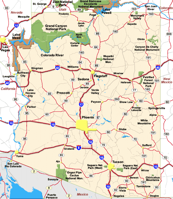
Arizona Map
N avigate Arizona Map, Arizona states map, satellite images of the Arizona, Arizona largest cities maps, political map of Arizona, driving directions and traffic maps.
All Arizona Cities Maps by Population
- Phoenix Map - (1,445,632)
- Tucson Map - (520,116)
- Mesa Map - (439,041)
- Chandler Map - (236,123)
- Glendale Map - (226,721)
- Scottsdale Map - (217,385)
- Gilbert Map - (208,453)
- Tempe Map - (161,719)
- Peoria Map - (154,065)
- Surprise Map - (117,517)
- Yuma Map - (93,064)
- San Tan Valley Map - (81,321)
- Avondale Map - (76,238)
- Casas Adobes Map - (66,795)
- Flagstaff Map - (65,870)
- Goodyear Map - (65,275)
- Lake Havasu City Map - (52,527)
- Buckeye Map - (50,876)
- Catalina Foothills Map - (50,796)
- Casa Grande Map - (48,571)
- Sierra Vista Map - (43,888)
- Maricopa Map - (43,482)
- Oro Valley Map - (41,011)
- Prescott Map - (39,843)
- Bullhead City Map - (39,540)
- Prescott Valley Map - (38,822)
- Sun City Map - (37,499)
- Apache Junction Map - (35,840)
- Marana Map - (34,961)
- El Mirage Map - (31,797)
- Kingman Map - (28,068)
- Drexel Heights Map - (27,749)
- Queen Creek Map - (26,361)
- Fortuna Foothills Map - (26,265)
- Florence Map - (25,536)
- San Luis Map - (25,505)
- Sahuarita Map - (25,259)
- Sun City West Map - (24,535)
- Fountain Hills Map - (22,489)
- Anthem Map - (21,700)
- Green Valley Map - (21,391)
- Nogales Map - (20,837)
- Rio Rico Map - (18,962)
- Douglas Map - (17,378)
- Tanque Verde Map - (16,901)
- Eloy Map - (16,631)
- Flowing Wells Map - (16,419)
- Payson Map - (15,301)
- New River Map - (14,952)
- Sierra Vista Southeast Map - (14,797)
- Fort Mohave Map - (14,364)
- Somerton Map - (14,287)
- Sun Lakes Map - (13,975)
- Paradise Valley Map - (12,820)
- Tucson Estates Map - (12,192)
- New Kingman Butler Map - (12,134)
- Coolidge Map - (11,825)
- Verde Village Map - (11,605)
- Cottonwood Map - (11,265)
- Camp Verde Map - (10,873)
- Chino Valley Map - (10,817)
- Show Low Map - (10,660)
- Arizona City Map - (10,475)
- Vail Map - (10,208)
- Gold Canyon Map - (10,159)
- Sedona Map - (10,031)
- Winslow Map - (9,655)
- Saddlebrooke Map - (9,614)
- Safford Map - (9,566)
- Picture Rocks Map - (9,563)
- Valencia West Map - (9,355)
- Tuba City Map - (8,611)
- Golden Valley Map - (8,370)
- Catalina Map - (7,569)
- Globe Map - (7,532)
- Page Map - (7,247)
- Tolleson Map - (6,545)
- Wickenburg Map - (6,363)
- Youngtown Map - (6,156)
- Village of Oak Creek (Big Park) Map - (6,147)
- Avra Valley Map - (6,050)
- Corona de Tucson Map - (5,675)
- South Tucson Map - (5,652)
- Snowflake Map - (5,590)
- Three Points Map - (5,581)
- Bisbee Map - (5,575)
- Guadalupe Map - (5,523)
- Litchfield Park Map - (5,476)
- Williamson Map - (5,438)
- Doney Park Map - (5,395)
- Summit Map - (5,372)
- Paulden Map - (5,231)
- Kayenta Map - (5,189)
- Rincon Valley Map - (5,139)
- Benson Map - (5,105)
- Holbrook Map - (5,053)
- Cave Creek Map - (5,015)
- Eagar Map - (4,885)
- Thatcher Map - (4,865)
- Colorado City Map - (4,821)
- Lake Montezuma Map - (4,706)
- Chinle Map - (4,518)
- Pinetop Lakeside Map - (4,282)
- Avenue B and C Map - (4,176)
- Taylor Map - (4,112)
- Whiteriver Map - (4,104)
- Clarkdale Map - (4,097)
- Lake of the Woods Map - (4,094)
- San Carlos Map - (4,038)
- Citrus Park Map - (4,028)
- Dewey Humboldt Map - (3,894)
- Willcox Map - (3,757)
- Oracle Map - (3,686)
- Quartzsite Map - (3,677)
- Fort Defiance Map - (3,624)
- San Manuel Map - (3,551)
- St. Johns Map - (3,480)
- Carefree Map - (3,363)
- Clifton Map - (3,311)
- Ajo Map - (3,304)
- Cornville Map - (3,280)
- Parker Map - (3,083)
- Williams Map - (3,023)
- Swift Trail Junction Map - (2,935)
- Wellton Map - (2,882)
- Black Canyon City Map - (2,837)
- Superior Map - (2,837)
- Heber Overgaard Map - (2,822)
- Window Rock Map - (2,712)
- Sacaton Map - (2,672)
- Cordes Lakes Map - (2,633)
- Kachina Village Map - (2,622)
- Whetstone Map - (2,617)
- Mohave Valley Map - (2,616)
- Linden Map - (2,597)
- Central Heights Midland City Map - (2,534)
- Sells Map - (2,495)
- Pima Map - (2,387)
- Star Valley Map - (2,310)
- Desert Hills Map - (2,245)
- White Mountain Lake Map - (2,205)
- Red Rock Map - (2,169)
- Golden Shores Map - (2,047)
- Dolan Springs Map - (2,033)
- Grand Canyon Village Map - (2,004)
- Congress Map - (1,975)
- Pine Map - (1,963)
- Bylas Map - (1,962)
- Beaver Dam Map - (1,962)
- Springerville Map - (1,961)
- Kearny Map - (1,950)
- Gila Bend Map - (1,922)
- Bagdad Map - (1,876)
- Huachuca City Map - (1,853)
- Miami Map - (1,837)
- Mescal Map - (1,812)
- Rio Verde Map - (1,811)
- Cienega Springs Map - (1,798)
- Pinetop Country Club Map - (1,794)
- Pirtleville Map - (1,744)
- Cibecue Map - (1,713)
- Lukachukai Map - (1,701)
- St. David Map - (1,699)
- Valle Vista Map - (1,659)
- Wagon Wheel Map - (1,652)
- Scenic Map - (1,643)
- First Mesa Map - (1,555)
- Claypool Map - (1,538)
- Salome Map - (1,530)
- Kaibito Map - (1,522)
- Cactus Flats Map - (1,518)
- Donovan Estates Map - (1,508)
- Mayer Map - (1,497)
- Morenci Map - (1,489)
- Ehrenberg Map - (1,470)
- St. Michaels Map - (1,443)
- Lechee Map - (1,443)
- Mammoth Map - (1,426)
- Tonto Basin Map - (1,424)
- North Fork Map - (1,417)
- Casa Blanca Map - (1,388)
- Joseph City Map - (1,386)
- Tombstone Map - (1,380)
- Peridot Map - (1,350)
- Many Farms Map - (1,348)
- Fredonia Map - (1,314)
- Centennial Park Map - (1,264)
- Meadview Map - (1,224)
- Ganado Map - (1,210)
- Canyon Day Map - (1,209)
- Tsaile Map - (1,205)
- Tubac Map - (1,191)
- Parks Map - (1,188)
- Dilkon Map - (1,184)
- Spring Valley Map - (1,148)
- Mountainaire Map - (1,119)
- Arivaca Junction Map - (1,090)
- Peach Springs Map - (1,090)
- Willow Valley Map - (1,062)
- Blackwater Map - (1,062)
- Naco Map - (1,046)
- Houck Map - (1,024)
- Six Shooter Canyon Map - (1,019)
- Bouse Map - (996)
- Rainbow City Map - (968)
- Moenkopi Map - (964)
- Second Mesa Map - (962)
- Strawberry Map - (961)
- Dudleyville Map - (959)
- Hotevilla Bacavi Map - (957)
- Leupp Map - (951)
- Arizona Village Map - (946)
- Patagonia Map - (913)
- Pinon Map - (904)
- Cameron Map - (885)
- Littletown Map - (873)
- Wilhoit Map - (868)
- Ak Chin Village Map - (862)
- Valle Map - (832)
- Shongopovi Map - (831)
- Komatke Map - (821)
- Sonoita Map - (818)
- Whitecone Map - (817)
- Hondah Map - (812)
- Martinez Lake Map - (798)
- Aguila Map - (798)
- Round Rock Map - (789)
- Queen Valley Map - (788)
- Wheatfields Map - (785)
- Fort Valley Map - (779)
- Mesa del Caballo Map - (765)
- Wittmann Map - (763)
- Low Mountain Map - (757)
- Sawmill Map - (748)
- Kykotsmovi Village Map - (746)
- Dennehotso Map - (746)
- Stanfield Map - (740)
- Teec Nos Pos Map - (730)
- Wenden Map - (728)
- Bluewater Map - (725)
- Maricopa Colony Map - (709)
- Seven Mile Map - (707)
- East Fork Map - (699)
- La Paz Valley Map - (699)
- Duncan Map - (696)
- Arivaca Map - (695)
- Pimaco Two Map - (682)
- Gadsden Map - (678)
- Icehouse Canyon Map - (677)
- Brenda Map - (676)
- Young Map - (666)
- Hayden Map - (662)
- Parker Strip Map - (662)
- Stotonic Village Map - (659)
- Yarnell Map - (649)
- Central Map - (645)
- Miracle Valley Map - (644)
- Rock Point Map - (642)
- Munds Park Map - (631)
- Sanders Map - (630)
- Santa Rosa Map - (628)
- Rancho Mesa Verde Map - (625)
- Gila Crossing Map - (621)
- Elephant Head Map - (612)
- Tacna Map - (602)
- Vicksburg Map - (597)
- Cactus Forest Map - (594)
- Orange Grove Mobile Manor Map - (594)
- Shonto Map - (591)
- Gisela Map - (570)
- Walnut Creek Map - (562)
- Tusayan Map - (558)
- York Map - (557)
- Tonalea Map - (549)
- Greasewood Map - (547)
- Sacaton Flats Village Map - (541)
- Burnside Map - (537)
- McNary Map - (528)
- San Jose Map - (506)
- Chilchinbito Map - (506)
- El Prado Estates Map - (504)
- Upper Santan Village Map - (495)
- Nazlini Map - (489)
- Round Valley Map - (487)
- Pinedale Map - (487)
- Red Mesa Map - (480)
- So Hi Map - (477)
- St. Johns Map - (476)
- Picacho Map - (471)
- Elfrida Map - (459)
- Goodyear Village Map - (457)
- Bitter Springs Map - (452)
- Bowie Map - (449)
- Tees Toh Map - (448)
- Cane Beds Map - (448)
- Seligman Map - (445)
- Jerome Map - (444)
- Pinal Map - (439)
- Winslow West Map - (438)
- Peeples Valley Map - (428)
- Lazy Y U Map - (428)
- Solomon Map - (426)
- Dateland Map - (416)
- Mesquite Creek Map - (416)
- Wall Lane Map - (415)
- Rough Rock Map - (414)
- Clay Springs Map - (401)
- Ash Fork Map - (396)
- Tumacacori Carmen Map - (393)
- Fort Thomas Map - (374)
- Lower Santan Village Map - (374)
- Winkelman Map - (353)
- Del Muerto Map - (329)
- White Hills Map - (323)
- Pisinemo Map - (321)
- Cedar Creek Map - (318)
- Sun Valley Map - (316)
- Littlefield Map - (308)
- Keams Canyon Map - (304)
- Topawa Map - (299)
- Amado Map - (295)
- Turkey Creek Map - (294)
- Jeddito Map - (293)
- Poston Map - (285)
- Steamboat Map - (284)
- Sunizona Map - (281)
- Tolani Lake Map - (280)
- Crystal Beach Map - (279)
- Drysdale Map - (272)
- Chloride Map - (271)
- Chuichu Map - (269)
- Nelson Map - (259)
- Wellton Hills Map - (258)
- Tonto Village Map - (256)
- Cornfields Map - (255)
- Indian Wells Map - (255)
- Cibola Map - (250)
- Klagetoh Map - (242)
- McNeal Map - (238)
- Dripping Springs Map - (235)
- Top of the World Map - (231)
- Beaver Valley Map - (231)
- Wet Camp Village Map - (229)
- Morristown Map - (227)
- East Globe Map - (226)
- Cottonwood Map - (226)
- Oxbow Estates Map - (217)
- Deer Creek Map - (216)
- Palominas Map - (212)
- Dragoon Map - (209)
- Supai Map - (208)
- San Miguel Map - (197)
- Arlington Map - (194)
- Woodruff Map - (191)
- Gu Oidak Map - (188)
- Pinion Pines Map - (186)
- Beyerville Map - (177)
- Wide Ruins Map - (176)
- Bryce Map - (175)
- Clacks Canyon Map - (173)
- Padre Ranchitos Map - (171)
- East Verde Estates Map - (170)
- Red Rock Map - (169)
- Sacate Village Map - (169)
- Why Map - (167)
- San Simon Map - (165)
- Elgin Map - (161)
- Ali Chuk Map - (161)
- Maish Vaya Map - (158)
- Theba Map - (158)
- Christopher Creek Map - (156)
- Oljato Monument Valley Map - (154)
- Buckshot Map - (153)
- Anegam Map - (151)
- Whispering Pines Map - (148)
- Alpine Map - (145)
- Fort Apache Map - (143)
- Kaka Map - (141)
- Pine Lake Map - (138)
- Wintersburg Map - (136)
- Kino Springs Map - (136)
- Seba Dalkai Map - (136)
- Cowlic Map - (135)
- Oatman Map - (135)
- Sehili Map - (135)
- Truxton Map - (134)
- Wikieup Map - (133)
- Ali Chukson Map - (132)
- Vaiva Vo Map - (128)
- Carrizo Map - (127)
- Utting Map - (126)
- Antares Map - (126)
- Yucca Map - (126)
- Kaibab Map - (124)
- Vernon Map - (122)
- Wahak Hotrontk Map - (114)
- South Komelik Map - (111)
- Copper Hill Map - (108)
- Katherine Map - (103)
- Rillito Map - (97)
- Haivana Nakya Map - (96)
- Hard Rock Map - (94)
- Franklin Map - (92)
- Moccasin Map - (89)
- Freedom Acres Map - (84)
- Sweet Water Village Map - (83)
- Chiawuli Tak Map - (78)
- Rye Map - (77)
- Jakes Corner Map - (76)
- Campo Bonito Map - (74)
- Cutter Map - (74)
- Ali Molina Map - (71)
- Washington Park Map - (70)
- McConnico Map - (70)
- Hackberry Map - (68)
- Oak Springs Map - (63)
- Geronimo Estates Map - (60)
- Tonopah Map - (60)
- Mojave Ranch Estates Map - (52)
- Charco Map - (52)
- Rock House Map - (50)
- Ventana Map - (49)
- Hunter Creek Map - (48)
- Aztec Map - (47)
- Ko Vaya Map - (46)
- Kohls Ranch Map - (46)
- Flowing Springs Map - (42)
- Greer Map - (41)
- Summerhaven Map - (40)
- Mead Ranch Map - (38)
- Valentine Map - (38)
- Concho Map - (38)
- Nolic Map - (37)
- El Capitan Map - (37)
- Santa Cruz Map - (37)
- Ak Chin Map - (30)
- Roosevelt Map - (28)
- Kohatk Map - (27)
- Nutrioso Map - (26)
- Alamo Lake Map - (25)
- Lupton Map - (25)
- Haigler Creek Map - (19)
- Bear Flat Map - (18)
- Sunwest Map - (15)
- Crozier Map - (14)
- Toyei Map - (13)
- Topock Map - (10)
- Tat Momoli Map - (10)
- Comobabi Map - (8)
- Grand Canyon West Map - (2)
- Willow Canyon Map - (1)
Largest Arizona cities map
Arizona Google Map, Street Views, Maps Directions, Satellite Images
Please Not : You can find local businesses, public places, tourist attractions via map view, satellite image, hybrid view, driving directions in Arizona Map. You'll also find a varity map of Arizona such as political, administrative, transportation, demographics maps following Google map.
Submit URL to Arizona :
Click for Arizona Direction »
Click for Arizona Street View »
Largest Cities Map of Arizona and Population
Phoenix Map - 1,445,632 Tucson Map - 520,116 Mesa Map - 439,041 Chandler Map - 236,123 Glendale Map - 226,721 Scottsdale Map - 217,385 Gilbert Map - 208,453 Tempe Map - 161,719 Peoria Map - 154,065 Surprise Map - 117,517 Yuma Map - 93,064 San Tan Valley Map - 81,321 Avondale Map - 76,238 Casas Adobes Map - 66,795 Flagstaff Map - 65,870 Goodyear Map - 65,275 Lake Havasu City Map - 52,527 Buckeye Map - 50,876 Catalina Foothills Map - 50,796Copyright Turkey Travel Guide - 2006 - 2023. All rights reserved. Privacy Policy | Disclaimer