Hawaii Map
N avigate Hawaii map, Hawaii country map, satellite images of Hawaii, Hawaii largest cities, towns maps, political map of Hawaii, driving directions, physical, atlas and traffic maps.
On upper left Map of Hawaii (+) beside zoom in and (-) sign to to zoom out via the links you can visit. Hawaii Map move the mouse over it via (left click) and clicking the image you can drag. Right upper Map, Satellite, Terrain icons via the map view, satellite, hybrid and terrain map can be switch between images.
map of hawaii

Discovering the Magic of Honolulu Top 10 Must-Visit Spots
Please subscribe on "World Guide" channnel on Youtube at youtube.com/c/WorldGuide
A Collection of Hawaii Maps and Hawaii Satellite Images
MAP OF HAWAII

HAWAII ISLANDS MAP
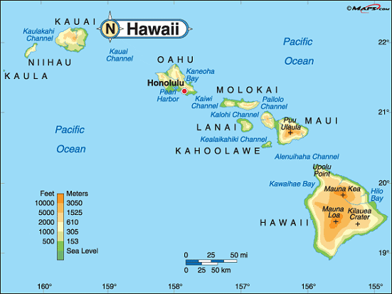

HAWAII MAP


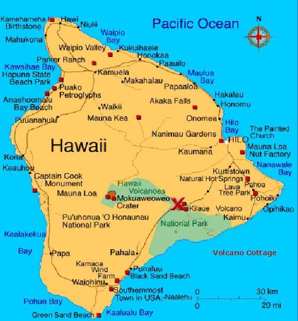
HAWAII BIG ISLAND MAP


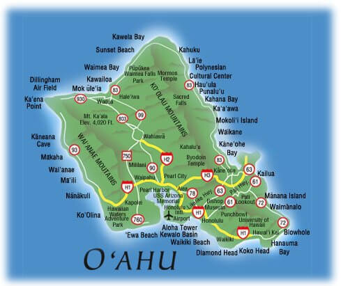
HAWAII CITIES MAP


HAWAII ISLANDS MAP


HAWAII ISLANDS MAP PASIFIC OCEAN


HAWAII MAP


HAWAII MAP ISLAND

HAWAII MAPS ISLANDS


HAWAII ROAD MAP


HAWAII TERRAIN MAP


MAP OF HAWAII


MAP OF HAWAII


MAP OF HAWAII BIG ISLAND


PRINCIPAL ISLANDS OF HAWAII MAP


THE ISLANDS OF HAWAII MAP


VOLCANO COTTAGE MAP OF HAWAII

Largest Cities Map of Hawaii and Population
Honolulu - 387,170 Pearl City - 47,698 Hilo - 43,263 Kailua - 38,635 Waipahu - 38,216 Kaneohe - 34,597 Mililani Town - 27,629 Kahului - 26,337 Ewa Gentry - 22,690 Mililani Mauka - 21,039 Kihei - 20,881 Makakilo - 18,248 Wahiawa - 17,821 Schofield Barracks - 16,370 Wailuku - 15,313For All Hawaii Cities Map
Cities Map of United States
New York City Map Los Angeles Map Chicago Map Brooklyn Map Houston Map Philadelphia Map Manhattan Map Phoenix Map San Antonio Map San Diego Map Dallas Map San Jose Map Jacksonville Map Indianapolis Map San Francisco Map Austin Map Columbus Map Fort Worth Map Charlotte Map Detroit MapCopyright Turkey Travel Guide - 2006 - 2023. All rights reserved. Privacy Policy | Disclaimer