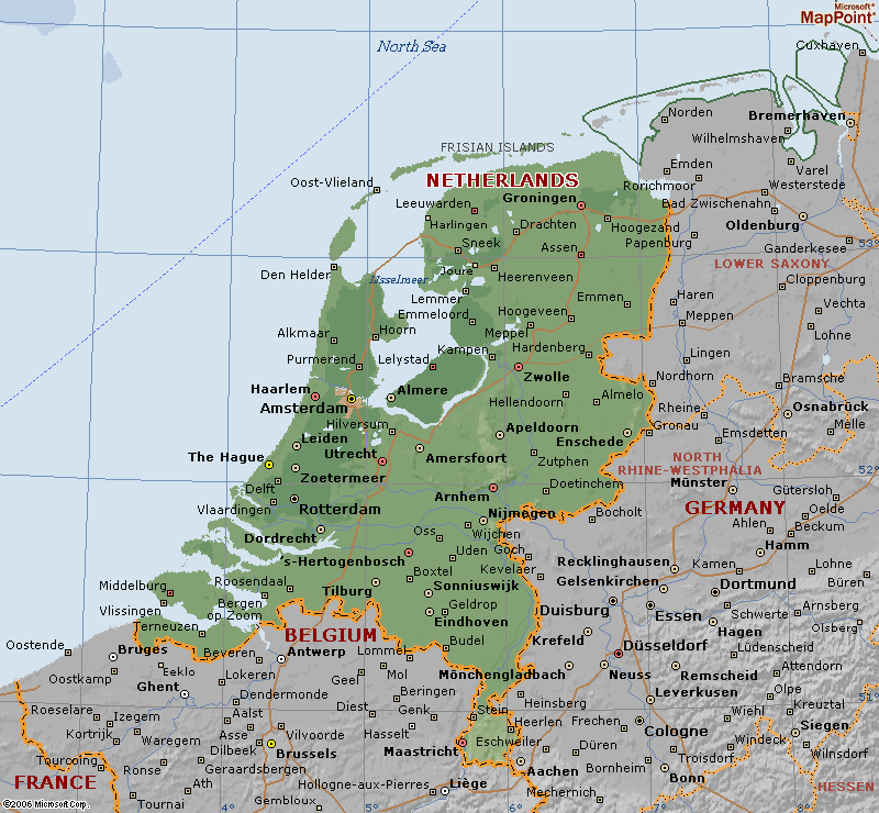
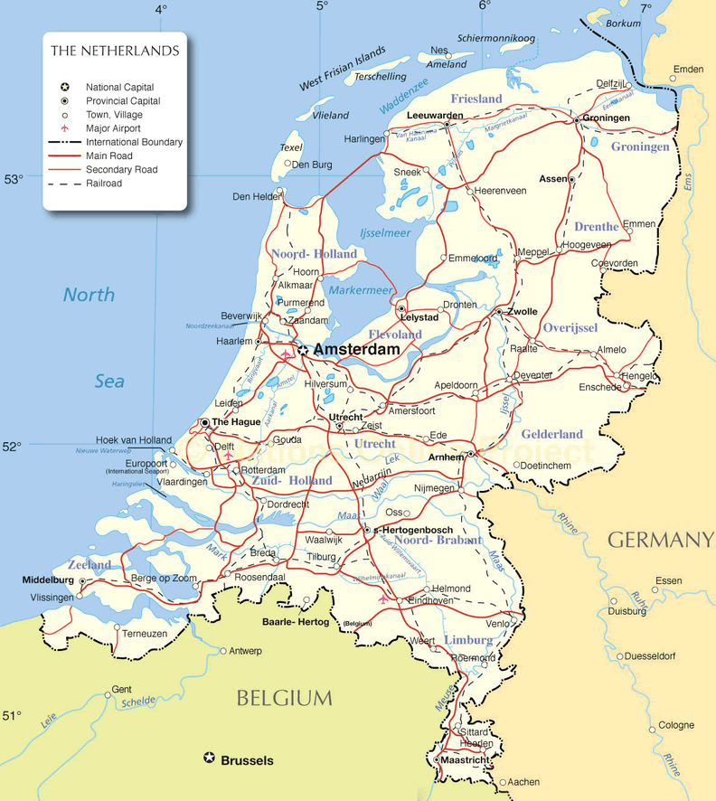
Netherlands Map
Navigate Netherlands Map, Netherlands countries map, satellite images of the Netherlands, Netherlands largest cities maps, political map of Netherlands, driving directions and traffic maps.

- Capital : Amsterdam
- Population : 16,751,323
- GDP : $840.433 billion
- Per Capita : $50,355
- Calling Code : +31
- Jobless Rate : 7.20%
- Time Zone : +1
Amsterdam's Magic: Canals, Culture, and Hidden Corners
Please subscribe on "World Guide" channnel on Youtube at youtube.com/c/WorldGuide
Getting the Best of Amsterdam: 10 Must-Do Activities in the Dutch Capital
With interactive Netherlands Map, view regional highways maps, road situations, transportation, lodging guide, geographical map, physical maps and more information. On Netherlands Map, you can view all states, regions, cities, towns, districts, avenues, streets and popular centers' satellite, sketch and terrain maps.
For more about Netherlands >>
Netherlands Map & Netherlands Satellite Images
Largest Cities Map of Netherlands
Enschede Map - Groningen Map - Haarlem Map - Haarlemmermeer Map - Heerlen Map - Helmond Map - Hengelo Map - Leeuwarden Map - Leiden Map - Maastricht Map - Nijmegen Map - Rotterdam Map - The Hague Map - Hertogenbosch Map - Sittard Geleen Map - Tilburg Map - Utrecht Map - Venlo Map - Zaanstad Map - Zoetermeer Map - Zwolle Map - Almere Map - Amersfoort Map - Amsterdam Map - Apeldoorn Map - Arnhem Map - Breda Map - Delft Map - Deventer Map - Dordrecht Map - Ede Map - Eindhoven Map - Emmen Map -A Collection of Netherlands Maps and Netherlands Satellite Images


Alphabetically Cities Map of Netherlands & Population of Netherlands Cities
Almere Map - Amersfoort Map - Amsterdam Map - Apeldoorn Map - Arnhem Map - Breda Map - Delft Map - Deventer Map - Dordrecht Map - Ede Map - Eindhoven Map - Emmen Map - Enschede Map - Groningen Map - Haarlem Map - Haarlemmermeer Map - Heerlen Map - Helmond Map - Hengelo Map - Leeuwarden Map - Leiden Map - Maastricht Map - Nijmegen Map - Rotterdam Map - The Hague Map - Hertogenbosch Map - Sittard Geleen Map - Tilburg Map - Utrecht Map - Venlo Map - Zaanstad Map - Zoetermeer Map - Zwolle Map -Netherlands Google Map, Street Views, Maps Directions, Satellite Images
Please Not : You can find local businesses, public places, tourist attractions via map view, satellite image, hybrid view, driving directions in Netherlands Map. You'll also find a varity map of Netherlands such as political, administrative, transportation, demographics maps following Google map.
Submit URL to Netherlands :
Please feel free share your comments and questions :
Please feel free share your comments and questions :
"Netherlands" related content to share on social media;


Copyright Turkey Travel Guide - 2006 - 2023. All rights reserved. Privacy Policy | Disclaimer